![]()
![]()
![]()

Trip 287 - July 31, 2023 (Monday)
Sowerby Creek FSR Hike
Near Hope, BC
Page 2 of 2
Liked: Several fine mountain views, colourful wild plants, a good creek view, no excessively steep sections.
Of Note: A rough FSR suitable for highly capable vehicles only (or hiking), numerous aggressive flies (mostly second half of the hike), limited shade, some parts of the FSR are getting overgrown, uneven ground, loose rocks, hiking poles and boots are highly recommended, as well as long pants, long-sleeve shirt and safety glasses.
Vancouver, Coast & Mountains Backroad Mapbook (2019 edition) Trailhead Coordinates: Page 5 (Chilliwack Lake) F1.
Other Trips in Hope BC Area: Thacker Mountain Trail, Flat Iron Peak Trail, Needle Peak Trail, Dog Mountain Trail, Jones Lake FSR Trip to Jones Lake, Yak Peak Trail, HBC Heritage Trail, Sowaqua Creek FSR, Zoa Peak Trail, Skagit River Trail, Skyline II Trail Hike, Silver Skagit Road, Mount Outram Trail, Othello Tunnels, Eaton Lake Trail, Mount Hope Lookout Trail, Town of Hope BC.
Other Forest Service Roads Trips: Chehalis (by Harrison Mills), Chilliwack Bench, Chilliwack Foley, Chilliwack Lake, Chuchinka-Colbourne (North of Prince George), Clear Creek (off Harrison East), Florence Lake (access to Stave Lake by Mission), Harrison East, Harrison East Second Trip, Harrison West, Lost Creek (by Mission), Lost Creek (by Mission), Mamquam River (by Squamish), Nahatlatch (near Boston Bar), Parsnip West (near Mackenzie), Scuzzy (by Boston Bar), Shovel Creek (off Harrison East), Sowaqua Creek (by Hope), Squamish River Main, Squamish River Ashlu, Squamish River E-Main, Squamish River FSR Washout, Windfall Creek (by Tumbler Ridge).
Follow @ihikebc TweetSowerby Creek Forest Service Road is located near Hope BC, by Highway 1 Exit 168 (Flood-Hope Road) and starts right at the gate of Silver Lake Provincial Park, which can be found in the vicinity of the 6.4 km mark of Silver Skagit Road. We were initially heading to Eaton Lake Trail further down Silver Skagit Road, but the road was closed until the Spring of 2024 (due to flooding damage) right at the spot where the right fork takes you across a bridge to Silver Lake Provincial Park, so we decided to hike Isolilllock Peak Trail instead, which is located off Sowerby Creek Forest Service Road.
As Sowerby Creek FSR is not suitable for anything but hiking or highly capable (at least one locker) short wheelbase narrow body 4x4s, we hiked to Isolilllock Peak trailhead from about the 800 meter mark of the FSR for 5.8 km, and realized that this unmarked route with 1,550 meters elevation gain would be way too much on a 30°C day. So, we hiked down Sowerby FSR a bit more, and made a 10.5 km (one way) hiking trip out of it all, counting from our parking spot at the 800 meter mark of the FSR. There were about 2-3 more kilometers left when we stopped, so there could be even more to see further down the road.
Sowerby Creek Forest Service Road has a decent hiking value, as the are no excessively steep stretches, no washouts or windfall, and the only three substantial challenges were a rather rough surface for much of the road, several sections of encroaching vegetation (skin and eyes scratching hazard), as well as dozens of aggressive flies in the second half of the FSR.
This hike has several very fine mountain views, numerous colourful wild plants, and one decent creek view as well.
* All hiking distances are based on a GPS odometer and are approximate.
28. At 2.98 km, there is a split. Go Right. The road on left ends in a few hundred meters.

Hike Sowerby FSR
29. Sowerby Creek Forest Service Road at 3.36 km from the start.

Sowerby Forest Service Road Near Hope British
Columbia Canada
30. There is limited tree cover on this road. Shade is not very plentiful. At 3.58 km.

Hike in Hope BC Area - Sowerby FSR
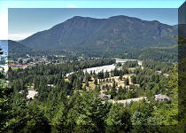
31. This fine mountain view can be observed at the 4.52 km mark of Sowerby Creek FSR.

Mountain View from Sowerby Forest Service Road
32. A zoomed view taken a bit earlier.

Mountain near Hope BC Canada
33. Some shade at the 5.58 km mark.

British Columbia Hiking - Sowerby FSR
34. At 6.62 km of Sowerby Creek FSR, we have reached Isolilllock Peak trailhead. Coordinates: N 49⁰16.946' W 121⁰28.045'. Elevation: 845 meters. There are no signs of any kind, but our GPS with Backroad Mapbook software has a trail ribbon which started a few hundred meters down the road on the right side. The trail description warned that the start of the trail has a lot of vegetation, and it sure is badly overgrown. Should you decide to hike this trail, note that it gains 1,550 meters in elevation, which was a non-starter for us on this hot day. You can avoid tackling all this vegetation by stepping into the forest on the right side after making the turn, as the forest is fairly open. There is no path or trail markers, so either have a GPS or employ your route finding skills to get going.

Sowerby FSR near Hope BC
35. This is what this trail looks like at the beginning. The forest just to the right doesn't look nearly as bad.

36. But we proceeded to the left at the split seen in photo #34, and, within 30 meters, there is this bridge.

Sowerby FSR Bridge
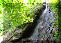
37. A fine creek view from the bridge.

Creek view from Sowerby Forest Service Road
38-39. And a neat mountain view looking back. Plain and zoomed.

Sowerby FSR Mountain View

BC Mountain
40. In hindsight, we should have stopped at the bridge and headed back. But the hope of new discoveries urged us forward. So, here is Sowerby Creek FSR at the 6.88 km mark.

Sowerby Creek FSR British Columbia
41. At 7.68 km, we are hiking arguably the best stretch of the road - quite smooth, with occasional shade and very little elevation change. The only issue were numerous aggressive flies, which increase in numbers the further you go.

Hiking on Sowerby Creek Forest Service Road
42. Things got tough soon thereafter. There was this multi-kilometer climbing section. Even though it wasn't too steep, the surface was strewn with loose stones, making for a tough go. The heat did not help. At 9.82km.

Sowerby Creek FSR rough stretch
43. Any very capable vehicle which would make it to the 10 km mark would likely be stopped by this road erosion.

Sowerby Creek FSR erosion
44. There was one more mountain view at 10.30 km of the hike.

Sowerby Creek FSR mountain view
45. But it was a tough stretch regardless. To add insult to injury, when we, exhausted, finally found a shady spot to sit down and chill, it turned out that we landed right on top of an ant colony, and dozens of unhappy ants quickly made their presence known. Boy, where did all our energy suddenly come from - we sure got going in a hurry!

Sowerby Creek Forest Service Road
46. "That's enough for today" moment came at the 11.30 km mark of Sowerby Creek Forest Service Road. Coordinates: N 49⁰16.413' W 121⁰27.697'. Elevation: 1,260 meters. We tied up two pieces of flagging tape to mark the spot, and headed back. There were at least a few more kilometers and a few more splits remaining, according to our GPS.

Hope BC Hiking on Sowerby Creek FSR
47. A good mountain view on the way back. The same mountain as in photo #31.

Sowerby Creek FSR mountain view
Aside from the flies, this is quite a decent hike, at least until the Isolilllock Peak trailhead. Recommended.


|
 |
Other Trips in Hope BC Area:
|
|
|
|
|
|
|
|
|
|
|
|
|
|
|
|
|
|
|
 |
|
|
|
|
|
Eaton
Peak Route
|
Skyline II West Trail
|
Eaton
Lake Hike 2
|
|
|


Other Trips:


![]()
![]()
![]()
ihikebc.com Trip 287 - Sowerby Creek FSR Hike (near Hope, BC) Page 2 of 2