![]()
![]()
![]()

Trip 192 - June 30, 2020 (Tuesday)
Hyland Pass Trail Hike
Babine Mountains Provincial Park
Near Smithers BC
Trailhead Location: At the end of Silver King Basin Trail in Babine Mountains Provincial Park, near the town of Smithers, which is approximately 370 kilometers West of Prince George via Highway 16.
Liked: Mountain views, no bugs.
Of Note: Easy-to-moderately steep trail with long stretches of loose stones and dirt – hiking poles and boots are highly recommended. Almost no tree cover – sun protection needed on sunny days.
Northern BC Backroad Mapbook (3rd edition) Trailhead Coordinates: Page 36 (Smithers) D4.
Related Website: Babine Mountains Provincial Park - BC Parks official website.
Other Trips in Babine Mountains Provincial Park: Harvey Mountain Trail Hike, Silver King Basin Trail Hike.
Hyland Pass Trail begins where Silver King Basin Trail ends, and serves as a connector trail between Silver King Basin and Cronin Creek Road trails. It's a short trail of just over 2 kilometers long, but good views come one after another. The trail is easy-to-moderately difficult, albeit with loose stones and dirt. A big plus was a lack of bugs, while all the other trails we have hiked so far this season were teeming with mosquitoes, with Silver King Basin Trail having a few as well.
It was an overcast day today, but, even with low-hanging clouds and no sunshine, the views were very impressive. Once the sun is out, this is going to be one spectacular hike.
To get to Hyland Pass Trail, either hike Silver King Basin Trail first (which we did earlier in the day), or, to get to Hyland Pass Trail from the other side, Cronin Creek Road Trail needs to be hiked, which we did not do, so no idea about the conditions. We did see a hiker coming from that direction, so it looks like it can be done. A big loop hike in Babine Mountains Provincial Park is possible as well - check out Silver King Basin trip report for details.
1. For directions on getting to the end of Silver King Basin Trail, check out our previous trip report. Here is the beginning of Hyland Pass Trail, just to the right of the information stand seen in photo #31 of that trip report. Coordinates: N 54⁰54.809’ W 126⁰53.007’. Elevation: 1,501 meters.

Hyland Pass Trailhead - Smithers Hiking
2. The first 200 meters or so are pretty smooth.

Hyland Pass Trail - Smithers Trail
3. Then, the trail becomes frequently strewn with loose stones and dirt.

Hyland Pass Trail - Smithers Hike
4. There are good views straight ahead, but also quite a view behind you. That's Joe L'Orsa cabin with its teal-coloured roof in the middle of the photo.

View from Hyland Pass Trail - Babine Mountains Provincial Park British
Columbia Canada
5. Despite being a high-altitude trail, Hyland Pass is not too hard.

Smithers Trail - Hyland Pass Trail
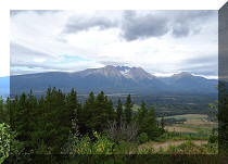
6. Closer to the 1 km mark of the trail, a most impressive sight slowly but steadily emerges in the front and to the right - a mountain surrounded by two smaller triangular mountains.

Babine Mountains Provincial Park
7-8. Quite a view. Approximate coordinates: N 54⁰54.631 W126⁰52.494’. Elevation: 1,695 meters.

View from Hyland Pass Trail - Hike in Smithers area

Babine Mountains Provincial Park British Columbia
9. A triangular mountain on the left.

View from Hyland Pass Trail - Hiking in Smithers Area
10. A triangular mountain on the right.

Babine Mountains Provincial Park near Smithers British Columbia Canada
Here is our video of the views from this location.
More ihikebc videos are on our YouTube Channel.
11. And the view behind gets better and better.

Trail in Smithers Area - Hyland Pass Trail
12-13. The path approaches the triangular mountain on the left...

British Columbia Hiking

Hyland Pass Trail
14...and then makes an almost 180⁰ turn while climbing up.

Hike in British Columbia
15. After that, Hyland Pass is right there. Coordinates: N 54⁰54.545’ W 126⁰52.020’. Elevation: 1,796 meters (295 meters elevation gain from the start of the trail).

Hyland Pass Trail in Babine Mountains Provincial Park
16. A few hundred meters later, we are in the open and start descending.

Babine Mountains Provincial Park - Hiking in British Columbia
17. The path disappears shortly, but Cronin Creek Road Trail is not too far ahead.

Hike in British Columbia
18. A neat mountain on the right.

Babine Mountains Provincial Park British Columbia Canada
We hiked for just over 2 kilometers, and stopped at coordinates N 54⁰54.573’ W 126⁰51.466’, elevation: 1,707 meters, before heading back. It was about 300 meters further to Cronin Creek Road Trail, according to our GPS. Hyland Pass Trail may not be easy to get to, but is rather easy to hike, and sure has a number of great views for such a short trail. Highly recommended.


|
 |
Other Trips in Smithers BC Area:
|
|
|
|
|
|
|
|
|
|
|
|
|
Fletcher-Gardiner Trail  |
Other Trips:


![]()
![]()
![]()
ihikebc.com Trip 192 - Hyland Pass Trail Hike (near Smithers BC)