![]()
![]()
![]()

Trip 314 - July 4, 2024 (Thursday)
Eaton Lake Trail Hike
Near Hope, BC
Liked: Eaton Lake, three fine waterfalls (the first one being the most impressive), shade in the forest, no bugs.
Vancouver, Coast & Mountains Backroad Mapbook (2019 edition) Trailhead Coordinates : Page 5 (Chilliwack Lake) G2.
103 Hikes in Southwestern British Columbia (2008 edition): hike #76.
Related Trip: 018 - Eaton Lake Trail Hike (partial).
>>> British Columbia Waterfalls Visits.
Follow @ihikebc TweetWe first hiked Eaton Lake Trail in April of 2010, and ran into deep snow. 14 years later, while hiking in July, the snow was gone. This moderately difficult trail takes 5.5 km to get to the lake, and it passes three waterfalls along the way. The first one, located just 700 meters from the trailhead, is by far the most impressive, and can make a good destination, if all you want is a short hike.
Going further, the second waterfall is not that special, and the third one is better than the second, but the viewing area is hazardous, so watch out! Moreover, past the first waterfall viewing area, which features a sturdy log bridge, there are two more Eaton Creek crossings, and they are fairly complicated. The next one after the first waterfall is a tilted log, with a broken rope support in the middle of the log, so be very careful not to lean on the rope too much. And the last creek crossing shortly before the lake is a bunch of semi-submerged slim trunks put together, though there is a rope to assist with crossing, That said, Spring runoffs may destroy these crossings, so prepare to wade.
To get to the trailhead, you need to take Silver Skagit Road to the 16.6 km mark. Unless you have a not-too-large 4x4, park on Silver Skagit Road and walk for 200 meters on the access road to the trailhead. Otherwise, it is possible to drive up to two camping spots at the Eaton Creek Recreation Site, which also features a pit toilet. Eaton Lake trailhead is located right there too.
*All trail distances are based on a GPS odometer and are approximate.
1. Here are Google Maps directions from Flood-Hope Road near Hope, BC to Eaton Lake Trail / Eaton Creek Recreation Site access road turnoff. It's 200 meters from there to the trailhead along a narrow 4x4 only road.
2. Here is the beginning of Silver Skagit Road in Hope, BC. Flood-Hope Road is just behind us. It's 16.6 km from here to the destination. The road surface soon turns into gravel and may have a lot of potholes, though it was being graded today.

Silver Skagit Road in Hope BC Canada
3-4. We are at the 16.6 km mark of Silver Skagit Road, with Eaton Creek Recreation Site / Eaton Lake Trail access road on the left side. Coordinates: N 49⁰14.873' W 121⁰23.517'. Elevation: 405 meters. Park here, unless you have a not-too-large 4x4.

Silver Skagit Road at Eaton Lake Trail access road

Start of Eaton Creek Recreation Site Access Road off Silver Skagit Road
near Hope BC
Here is our video of driving on Silver Skagit Road from Hope to this point.
5. Eaton Lake Trail access road 30 meters from Silver Skagit Road. It is steeper than it looks.

Eaton Lake Trail Access Road / Eaton Creek Recreation Site Access Road
6. At 140 meters, the access road continues on the left side, and access to one of the camping spots is on the right side.

Eaton Creek Recreation Site near Hope, British Columbia, Canada
7. At 205 meters, arriving to the end of the access road. Another camping spot is on the right side, and Eaton Lake trailhead is on the left.

Camping near Hope BC - Eaton Creek Recreation Site
8. Eaton Lake trailhead. Coordinates: N 49⁰14.777' W 121⁰23.475'. Elevation: 430 meters. Non-motorized trail. Foot traffic only.

Eaton Lake Trail trailhead
9. Eaton Lake Trail at the 70 meter mark. At 300 meters, Eaton Creek starts flowing along the trail. And, at 420 meters, the trail starts going up rather steeply.

Hiking in Hope BC Area - Eaton Lake Trail
10. At 650 meters from the trailhead.

Eaton Lake Trail
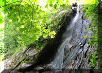
11. Just 50 meters later, arriving to the first (and the most impressive) Eaton Lake Trail waterfall.

British Columbia Hiking Eaton Lake Trail near Hope BC
12. The log bridge is very sturdy.

Log Bridge on Eaton Lake Trail
13-15. Eaton Creek Falls #1. If you want a closer look, it is much safer to approach on the left side (if facing the waterfall). Do watch out for slippery stones and logs.


Eaton Creek Falls #1
Here is our video of the first waterfall.
16. Eaton Lake Trail past the first waterfall, at 1.40 km from the trailhead. Aside from several upcoming creek crossings, it's not a complicated trail. Just steady elevation gain until almost by the lake.

Hike in British Columbia Canada - Eaton Lake Trail
17. The second waterfall at the 2.30 km mark. Coordinates: N 49⁰14.814' W 121⁰22.537'. Elevation: 790 meters.

Eaton Creek Falls #2
Here is our video of the second waterfall.
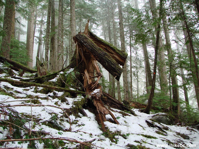
18-19. And, at 2.48 km of Eaton Lake Trail, we have reached this very distinctive broken tree.


Broken Tree on Eaton Lake Trail British Columbia Canada
20. The same tree in 2010.
21. More forest hiking. Shade, no bugs, good times. At 3.60 km.

Hope BC Area Trail - Eaton Lake Hike
22. The third waterfall arrives at the 4.10 km mark of Eaton Lake Trail. It is about 50 meters off the trail. Coordinates: N 49⁰14.808' W 121⁰21.804'. Elevation: 1,250 meters. Be careful, as it is a dangerous viewing area, quite slippery and steeply inclined.

Eaton Creek Falls #3
Here is our video of the third waterfall.
23. At 4.35 km, there this the first iffy creek crossing. The log is tilted, and the middle rope support is broken. You may want to avoid this log, if it is slippery.

Tilted log creek crossing on Eaton Lake Trail
24. Eaton Creek view from the log.

Eaton Creek British Columbia
25. Looking back. As you can see, the log is quite tilted, and there is NO support in the middle, as that wooden stake holding the rope is broken at the bottom.

Eaton Creek Log crossing
26. But wait, there is more! At 4.65 km, there is yet another iffy creek crossing. This time, there are just a bunch of semi-submerged rather slim trunks serving as a bridge.

Tree trunks Eaton Creek crossing
27. Having conquered that obstacle, turn left, and, at 4.85 km, there is a small boulder field. Nothing too complicated.

Eaton Lake Trail boulder field
28. Then, there is a bit more forest hiking. At 5.10 km here.

Eaton Lake Trail
29-33. And, at 5.50 km, we have arrived to Eaton Lake. Coordinates: N 49⁰15.024' W 121⁰21.396'. Elevation: 1,330 meters (900 meters elevation gain from the trailhead for an average grade of 16%). Left to right followed by a panorama.

Eaton Lake British Columbia

Eaton Lake near Hope NC

Eaton Lake

Eaton Lake Canada

Eaton Lake panorama
Here is our video of Eaton Lake.
More ihikebc videos are on our YouTube Channel.
34-35. Hey, grads of 1982, your sign is still here!


Grads 1982 "Time is on our side" tree sign at Eaton Lake
We then hiked Eaton Peak Trail, which starts here. As for Eaton Lake Trail, the lake looks fine (with a few flat areas for camping), the waterfalls are good to see, and the creek crossings can be complicated. Highly recommended.


|
 |
Other Trips in Hope BC Area:
|
|
|
|
|
|
|
|
|
|
|
|
|
|
|
|
|
|
|
 |
|
|
|
|
|
Eaton Peak
Route
|
Skyline II West Trail
|
Town of Hope
Visit
|
|
|


Other Trips:


![]()
![]()
![]()
ihikebc.com Trip 314 - Eaton Lake Trail Hike
(near Hope, BC)