![]()
![]()
![]()

Trip 177 - September 2, 2019 (Monday)
Mount Kobau Trails Hike
Near Osoyoos BC
Location: Southern British Columbia, off Highway 3, approximately 30 kilometers West of the town of Osoyoos.
Liked: Two short and rather easy trails to fine lookout points. Valley and rolling hills views. No bugs.
Of Note: Long (20 km) and rough trailhead access road (regular clearance 2WD vehicles ok). A few short steep sections. Hiking poles and boots are recommended. The trails are popular. Some cow dung present. Steep unbarricaded drop-offs at Mount Kobau Lookout.
Thompson Okanagan BC Backroad Mapbook (4th edition) Trailhead Location Coordinates: Page 3 (Keremeos) F5.
Mount Kobau has two trails which share the trailhead, but go in the opposite direction: a 3.5 km Chopaka Lookout Loop Trail, and 1.3 km (return distance) Mount Kobau Lookout Trail. The trails are quite popular, and we have met about 15 people on a stat holiday in the few hours we spent hiking the trails on Mount Kobau. Both trails feature lookouts where one can observe the town of Osoyoos, Osoyoos Lake, and the valley. Pleasant rolling hills surround you for much of Chopaka Lookout Loop Trail, while Mount Kobau Lookout Trail leads to very impressive views in just under 10 minutes of hiking.
The only substantial downside is a brutal forest service road, which begins at Highway 3, and goes to the trailhead. It's nearly 20 kilometers long, and, while there are few potholes and no cross-ditches, the surface is so rough, that going above 25 km/h is, for the most part, simply bone-jarring. Thus, it would take at least 45 minutes of driving to get to the trailhead from Highway 3, unless you do not mind a very rough ride, and would drive faster.
1. We are Eastbound on BC Highway 3, with Keremeos behind us, and Osoyoos further ahead.

BC Highway 3 Eastbound between Keremeos and Osoyoos
2. Getting ready to turn left from Highway 3 onto Kobau Lookout Forest Service Road. It's about 37 km West to Keremeos from here, and 11 km further East to Osoyoos.

BC Highway 3 Eastbound at Kobau Lookout FSR turnoff
3. The beginning of Kobau Lookout FSR. Coordinates: N 49⁰05.064' W 119⁰35.647'. Elevation: 712 meters.

Kobau Lookout Forest Service Road near Osoyoos British Columbia Canada
4. Kobau Lookout FSR is rough and long.

Kobau Lookout Forest Service Road
5. There is a good view at the 10.5 km mark of this forest service road.

View from Kobau Lookout FSR near Osoyoos BC
6. Approaching the parking lot.

Kobau Lookout FSR near Osoyoos British Columbia Canada
7. Arriving to Mount Kobau parking area. It took 19.7 km and 1,105 m in elevation gain to get here from Highway 3. Coordinates: N 49⁰06.794' W 119⁰40.415'. Elevation: 1,817 meters.

Mount Kobau parking lot
8. The trails start on the left side of the parking lot.

Mount Kobau British Columbia Canada
9. We first hiked Chopaka Lookout Loop Trail, which is 3.5 km long.

Osoyoos Hiking - Mount Kobau Trails
10. It's a pleasant hike through rolling hills, with little elevation change.

Hiking in Osoyoos - Chopaka Lookout loop trail on Mount Kobau
11. Approximately 390 meters from the start of the hike, there is this peculiar concrete pipe near the trail on the left side.

Osoyoos Trail - Chopaka Lookout Trail on Mount Kobau
12. Very interesting.

Hike in Osoyoos Area on Mount Kobau
13. What is this thing? Coordinates: N 49⁰06.577' W 119⁰40.428'. Elevation: 1,831 meters.

Mysterious Installation on Mount Kobau near Osoyoos BC
14. In addition to the mysterious concrete pipe, this spot features a neat view.

View from Mount Kobau by Osoyoos BC Canada
15. The town of Osoyoos as seen from this location with much zoom.

View of Osoyoos from Mount Kobau
16. Moving on, rolling hills surround us again.

Osoyoos Hike - Chopaka Lookout Trail on Mount Kobau
17. It really is a very pleasant hike.

Chopaka Lookout Trail - Hike in Osoyoos Area
18. Arriving to Chopaka Lookout, 1.7 km from the trail start.

BC Hiking - Chopaka Lookout Trail
19. A fine valley below.

Valley View from Chopaka Lookout on Mount Kobau - BC Hiking
20. With some zoom.

Hike in British Columbia - Mount Kobau near Osoyoos
Here is our video of the views from this location.
21. The trail then briefly goes through a stand of trees...

Hiking in British Columbia - Chopaka Lookout Trail near Osoyoos BC
22. ...and, at the 3 km mark, reaches a tower. Coordinates: N 49⁰06.886' W 119⁰40.537'. Elevation: 1,864 meters.

Mount Kobau near Osoyoos BC Canada
23. There is nothing to see here but the tower itself. It's a fine-looking tower, and it comes with two prominently displayed warnings: "your presence has been detected, you are being monitored", and "extreme hazard, tower unsafe, keep back 200 meters" (though the trail passes by much closer).

Communication Tower on Mount Kobau
24. Continue on the road for the next 500 meters.

Hiking on Mount Kobau near Osoyoos British Columbia
25. Make a right turn at this intersection, and you would complete the loop and arrive to the parking lot within a few minutes.

British Columbia Hiking - Chopaka Lookout Trail
26. Next is Mount Kobau Lookout Trail.

Mount Kobau Lookout Trailhead - Osoyoos Hiking
27. It's really short - took us less than ten minutes to get to the top, after tackling a moderately steep hill lined up with some burned trees further on.

Trail in Osoyoos Area - Mount Kobau Lookout Trail
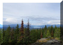
28. The views of Osoyoos Lake, the town of Osoyoos, the hills, and the valley from the lookout are very impressive. Just watch for steep unbarricaded drop-offs. The photos are left-to-right.


View from Mount Kobau Lookout near Osoyoos British Columbia Canada
Here is our video of the views from this location.
More ihikebc videos are on our YouTube Channel.
The Mount Kobau access road is long and rough, but the trails are easy, and the views are good. Recommended.


|
 |
Other Trips:


![]()


![]()
![]()
![]()
ihikebc.com Trip 177 - Mount Kobau Trail Hike (Near Osoyoos BC)