![]()
![]()
![]()

Trip 315 - July 4, 2024 (Thursday)
Eaton Peak Trail Hike (partial)
Near Hope, BC
Liked: Mountain views, Eaton Lake view, shade in the forest.
Vancouver, Coast & Mountains Backroad Mapbook (2019 edition) Trailhead Coordinates : Page 5 (Chilliwack Lake) G2.
Related Trip: Eaton Lake Trail Hike.
Follow @ihikebc TweetEaton Peak Trail starts at the end of much easier Eaton Lake Trail, and goes for about 2 kilometers to the base of Eaton Peak, which then requires non-technical climbing to reach the top. The snow was still present closer to Eaton Peak, so one likely have to wait until at least August for all the snow to be gone. In addition to the steepness of Eaton Peak Trail, another challenge is a fairly substantial boulder field which needs to be hiked up, and down. The higher you get the better the views of Mount Grant, Eaton Lake, and other mountains.
*All trail distances are based on a GPS odometer and are approximate.
1. Here are Google Maps location of Eaton Peak.
2. Eaton Peak Trail starts at Eaton Lake, which is at Coordinates: N 49⁰15.024' W 121⁰21.396'. Elevation: 1,330 meters. Check out the previous trip report for directions on how to get to Eaton Lake. The trailhead is not well-defined, and it would be very useful to have a GPS, preferably with this trail mapped. The trail is more or less flagged now all the way to the alpine, but flagging tape may not last long in this environment - snow, overgrowth, etc. Anyway, if you are facing Eaton Lake, the trail starts at the 2 o'clock position, about 50 meters from the lake. In the photo below, we are by the lake and are looking in the direction of the trailhead.

Eaton Peak Trailhead at Eaton Lake Hope BC Canada
3. Eaton Peak is a very steep trail, suitable for experienced well-equipped hikers only. At 70 meters of the hike.

Hiking in Hope BC Area - Eaton Peak Trail
4. At 110 meters of Eaton Peak Trail.

Eaton Peak Trail
5. Now at the 260 meter mark of Eaton Lake Trail. Coordinates: N 49⁰14.941' W 121⁰21.341'. Elevation: 1,400 meters.

Hiking in British Columbia - Eaton Peak Trail
6. At 450 meters of Eaton Peak Trail. Relentlessly steep. And there are some bugs.

Steep Eaton Peak Trail
7. At 660 meters.

Eaton Peak Trail Hike near Hope British Columbia Canada
8. At 800 meters, Eaton Peak Trail becomes easier for a short bit. Coordinates: N 49⁰14.818' W 121⁰21.282'. Elevation: 1,540 meters. 26% average trail grade up to this point.

Eaton Peak Trail
9. At 960 meters, still walking on a relatively flat stretch of Eaton Peak Trail. Coordinates: N 49⁰14.772' W 121⁰21.284'. Elevation: 1,550 meters.

Hike in Canada - Eaton Peak Trail near Hope BC
10. Looking at Mount Grant at the 1.06 km mark. Coordinates: N 49⁰15.024' W 121⁰21.396'. Elevation: 1,330 meters.

Mount Grant near Hope BC Canada
11. At 1.15 km, the easy part is over, and fairly dangerous (especially on the way down) boulder hopping is about to begin. Coordinates: N 49⁰14.724' W 121⁰21.247'. Elevation: 1,570 meters.

Eaton Peak Trail Boulder Field
12-13. At 1.23 km, looking to the right we see Eaton Peak. Plain and zoomed views.


Eaton Peak
14-15. At 1.32 km, looking back we see Mount Grant again (it can be hiked too, but is, apparently, much steeper and harder than Eaton Peak Trail). Plain and zoomed.


Mount Grant - British Columbia - Canada
16. Still climbing the boulder field at the 1.34 km mark.

Boulder Field - Eaton Peak Hike - Hope BC Area
17. Looking down.

Eaton Peak Hike near Hope BC Canada
18. Looking a bit to the right at Eaton Peak. Still lots of snow in early July.

Eaton Peak British Columbia Canada
19-24. At 1.43 km, we have reached the end of our today's hike. Coordinates: N 49⁰14.629' W 121⁰21.197'. Elevation: 1,650 meters (320 meters elevation gain from the trailhead for an average grade of 22%). It was possible to proceed further. Eaton Peak requires non-technical climbing to reach the top. Left to right.


Mount Grant and Eaton Lake


Eaton Peak
Here is our video of the views from this location.
More ihikebc videos are on our YouTube Channel.
Eaton Peak Trail is very steep and features a semi-dangerous boulder field. The fine views serve as a worthwhile compensation. Recommended.


|
 |
Other Trips in Hope BC Area:
|
|
|
|
|
|
|
|
|
|
|
|
|
|
|
|
|
|
|
 |
|
|
|
|
|
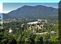
Town of Hope
Visit
|
Skyline II West Trail
|
Eaton Lake
Hike 2
|
|
|


Other Trips:


![]()
![]()
![]()
ihikebc.com Trip 315 - Eaton
Peak Trail Hike (near Hope, BC)