![]()
![]()
![]()

Trip 175 - August 13, 2019 (Tuesday)
Horsefly Lake Provincial Park Visit
Near Horsefly BC
Location: South-Central British Columbia, approximately 14 kilometers East of the settlement of Horsefly, which itself is located about 50 kilometers East of BC Highway 97 near 150 Mile House / Williams Lake.
Liked: Horsefly Lake views, a fine short trail to Horsefly Lake lookout.
Of Note: No lifeguards on duty in BC provincial parks, some noise from vehicles passing by on Horsefly Lake Road, some bugs on the hiking trail, a partially hidden ditch by the trailhead.
Cariboo Chilcotin Coast BC Backroad Mapbook (4th edition) Park Location Coordinates: Page 30 (Horsefly) C2.
Related Website: Horsefly Lake Provincial Park - BC Parks Official Website.
Horsefly Lake Provincial Park is located by Horsefly Lake Road. According to BC Parks website, it has 23 campsites. The park also has a small grassy/stony beach, a boat launch, and a short neat trail to the Horsefly Lake lookout. On the day of our visit, there were many available camping spots. Also, if the park is full, there are free campgrounds further down Horsefly Lake Road.
1. We are driving on Horsefly Lake Road, with Horsefly Lake Provincial Park entrance seen on the right side. Coordinates: N 52⁰23.097' W 121⁰17.374'. Elevation: 797 meters. Check out our Horsefly Lake Road Visit trip report for directions on getting up to this point from BC Highway 97 near 150 Mile House / Williams Lake. This is the same photo as photo #15 of that trip report.

Horsefly Lake Road at Horsefly Lake Provincial Park near Horsefly British
Columbia Canada
2. The entrance to Horsefly Lake Provincial Park.

Horsefly Lake Provincial Park Entrance
3. The rules board.

Horsefly Lake Provincial Park Rules
4-5. There is no cell service here, but a good old free landline phone is there for all your calling needs. An attached note indicates useful phone numbers, and promises free Wi-Fi Internet at the Horsefly library.

Telus Landline Phone at Horsefly Lake Provincial Park

Horsefly BC Useful Phone Numbers
6. The camping spots are located on both sides of the road.

Horsefly Lake Provincial Park British Columbia
7. A spot with a view.

Horsefly Lake Provincial Park Camping Spot
8. A better view of Horsefly Lake from the boat launch area.

Horsefly Lake seen from Horsefly Lake Provincial Park near Horsefly BC Canada
9. Here is the day use parking area.

Horsefly Lake Provincial Park Day Use Parking Area
10. A short path leads to the beach. There are no lifeguards on duty in BC provincial parks.

Beach at Horsefly Lake Provincial Park
11. Changerooms and picnic tables at the beach.

Horsefly Lake Provincial Park Change Rooms and Picnic Tables
12. Horsefly Lake seen from the beach.

Horsefly Lake
13. On the other side of the day use parking area, another short path leads to Horsefly Lake lookout trailhead.

Horsefly Lake Provincial Park British Columbia Canada
14. Here is the trailhead. Coordinates: N 52⁰23.022' W 121⁰17.418'. Elevation: 791 meters. A sign indicates approximately one hour round trip. It would probably take less than that.

Horsefly Lake Provincial Park Horsefly Lake Lookout Trailhead
15. Beware of a partially hidden mud-filled ditch by that sign, just about where we were standing to take the above photograph - we were backing up to take a better picture, stepped into the ditch, and had to deal with a muddy sock.

16-17. The trail is very short (less than 800 meters), and quite pleasant. There are some bugs present, and it does have a few steep sections. It took us 15 minutes to get to the top, and 10 minutes to get back.

Hike in Horsefly Lake Provincial Park

Horsefly Lake Lookout Trail - Horsefly Hiking
18. A pleasant scene at about the 450 meter mark.

Horsefly Lake Provincial Park near Horsefly BC Canada
19. There are two benches at the lookout. The first bench has no view, as the trees blocked it completely. The second bench does have a decent view of Horsefly Lake, as seen below.

Horsefly Lake Lookout
20. For a better view, go down a steep path for a hundred meters or so, and walk through some bushes on the left side. Watch out for unbarricaded drop-offs.

Trail in Horsefly Lake Provincial Park
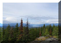
21. That's much better.

Horsefly Lake British Columbia Canada
Horsefly Lake Provincial Park is a pleasant place to camp, swim, fish, boat, and go for a short hike.


|
 |
Other Trips in Horsefly BC Area:
|
Horsefly Lake Road
|
|
Other Trips:


![]()


![]()
![]()
![]()
ihikebc.com Trip 175 - Horsefly Lake Provincial Park Visit (Near Horsefly BC)