![]()
![]()
![]()

Trip 106 - June 4, 2016 (Saturday)
Sikanni River Trail Hike
Between Fort St. John and Fort Nelson BC
Page 1 of 2
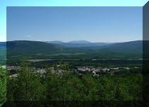
Location of the trailhead: Northeastern British Columbia,
24th kilometer of Mile 171 (Grassy) Road off Alaska
Highway, approximately midway between Fort St. John and Fort Nelson.
Liked: Several fine mountain and river views, lots of shade, decent trail condition, meeting free-roaming horses.
Of note: Remote wilderness area, the trail is not marked, several creek crossings required, lots of mud when wet, horse manure galore, the road from Alaska Highway to the 3-way split in photo #1 is much more rutted and potholed than last year.
Northern BC Backroad Mapbook (3rd edition) Trailhead Coordinates: Page 73 (Pink Mountain) B6.
Related Trip: Sikanni Chief Falls.
Sikanni River Trail goes into the depth of Muskwa-Kechika Management Area along the banks of Sikanni River. The trail is not marked, so we spent a considerable amount of time figuring out where to go next and getting a bit lost. However, the general direction is clear: the river is to the left, so, whenever possible, take a left turn. This is a very long trail (30+ kilometers one way), and our goal was at least to reach Trimble Lake, but we didn't get there before going back. However, there were still great views to be had. Here is how it all went down:
1. We start our coverage with a 3-way split, which is the same split as seen in photo #11 of Sikanni Chief Falls Visit trip report. Check out that trip report for directions up to this point. From here, you would go left to get to Sikanni Chief Falls trailhead in about 2 kilometers, and would go straight to get to Sikanni River trailhead in about 8 kilometers.

Mile 171 (Grassy) Road off Alaska Highway
2. Thus, we went straight, and, right at the beginning of the road in the middle, there is this sign indicating that Sikanni River Ranch is down there as well. The road conditions after the split are pretty good, but, from Alaska Highway all the way to the 3-way split, the road now is much more rutted than last year, and with a whole lot of deep potholes. You should still be able to easily make it in a high-clearance 2WD vehicle, though.

Mile 171 (Grassy) Road to Sikanni River Trail trailhead British Columbia
Canada
3. Nearly 8 kilometers after the split, the gate prevents further vehicular access. Coordinates: N 57⁰15.901' W 123⁰04.969'. Elevation: 1,000 meters. From here, it's either hiking (which is going to take forever), or, better, biking (which is what we did), or horse riding. The road continues for 0.5 km to the left of the gate and leads to an abandoned air strip with several rudimentary campsites on the sides, with even a few makeshift pit toilets. There are also piles of horse manure all over the place there, just like along the trail. The origin of the manure would become clear on the next page of our trip report.

Sikanni River Trail Trailhead off BC Highway 97
4. After spending a peaceful night by the airstrip, we started our biking trip the next morning. The road was in a pretty good shape after the gate. Up to the point pictured in the photo below, there was a steady gain in elevation, which made for a fast bike ride on the way back.

BC Hike -
Sikanni River Trail British Columbia Canada
5. The first split (of many) arrived soon - we stayed left (straight), as the river was somewhere to our left too, though not seen or heard at this point. Coordinates: N 57⁰15.610' W 123⁰08.934'. Elevation: 1,078 meters.

British Columbia Hiking - Sikanni River Trail
6. And, then, the second split. Another left path to take. Coordinates: N 57⁰15.362' W 123⁰10.247'. Elevation: 1,107 meters. It's remarkable because after we went left as per usual, there was a long descent, which was great since we had a bicycle, but then it took 15 minutes to push the bike up that hill on the way back.

Sikanni River Trail - Hike in British Columbia
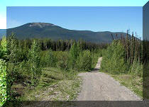
7. And after the steepest hill of the trail, there was the longest straight stretch. It was very serene to just pedal on a smooth road with trees on both sides.

Sikanni River Trail - Hiking in British Columbia Canada
8. The third split is at coordinates N 57⁰14.867' W 123⁰14.764'. Elevation: 1,111 meters. We should have turned to the right this time. But we didn't know any better, and that was not bad at all, since, after turning left at the split seen in the photo below, we ended up...

Sikanni River Trail off Alaska Highway BC Canada
9...we ended up...

10...at Sikanni River Ranch.

Sikanni River Ranch off BC Highway 97 via Mile 171 (Grassy) Road
11. We turned around at the gate (it was a short side trip), and went back to the split seen in photo #8. Took a right turn this time, and, for a moment, the vision of the gruelling Christina Falls Trail hike came to mind, with all the mud ahead of us.

Sikanni River Trail
12. Fortunately, it was a very short muddy stretch, and the road went back to its smooth self right after that. In the meanwhile, we have reached a short side trip to a pond. The left split is pictured below. Coordinates: N 57⁰14.740' W 123⁰15.405'. Elevation: 1,112 meters.

Sikanni River Trail turnoff to pond
13. Right after turning left.

Sikanni River Trail spur trail to a pond
14. Not bad, eh. Just watch out for boggy areas near the edge of the water.

Pond off Sikanni River Trail British Columbia Canada
15. Moving on. Another split. Coordinates: N 57⁰15.225' W 123⁰16.450'. Elevation: 1,092 meters. Stay left.

Sikanni River Trail Northeastern British Columbia Canada
16. And here is the first creek crossing. Coordinates: N 57⁰15.070' W 123⁰17.251'. This is where we have encountered several ATVs on the way back, as ATVs are allowed on Redfern Lake Trail (entrance further North off Alaska Highway), and there is a connector between Redfern Lake and Sikanni River trails.

Sikanni River Trail
17. Crossing could be an issue when the water is high. And, yes, take a left right after crossing the creek (going right would probably lead to Redfern Lake Trail, as that's where the ATVs went).

Sikanni River Trail first creek crossing
18. So, we turned left after crossing the creek, and, in no time, there was another split. We turned left again...

Sikanni River Trail Province of British Columbia Canada
19. ...and ended up at the back entrance to Sikanni River Ranch.

Back entrance to Sikanni River Ranch
20. Went back to the split seen in photo #18, and went to the right.

Sikanni River Trail BC Canada
21. Good views started to appear shortly thereafter...

Mountain View Sikanni River Trail British Columbia Canada
22. ...as well as the second creek crossing. But, before the crossing seen ahead in the photo below, there is a short path on the left - the turnoff is also seen in this photo.

Sikanni River Trail
23. The path after turning left.

BC Trail - Sikanni River Trail off Alaska Highway between Fort St. John
and Fort Nelson
24. And we are finally on the bank of Sikanni River, with a great view to boot.

Sikanni River and Mountain View off Sikanni River Trail Northeastern BC
Canada
Our Sikanni River Trail Hike Trip Report Continues on Page 2.


|
 |
Other Trips off Alaska Highway / BC Hwy 97:
|
|
|
|
|
|
|
Other Trips:


![]()


![]()
![]()
![]()
ihikebc.com Trip 106 - Sikanni River Trail Hike (Off Alaska Highway / BC Hwy 97) Page 1 of 2