![]()
![]()
![]()

Trip 159 - July 12, 2019 (Friday)
Crazy Creek Trail Hike
Off Highway 20 Near Tatla Lake BC
Liked: Excellent mountain views, shade in the forest.
Of Note: Remote wilderness area, numerous mosquitoes in the second half of the trail, a very long marshy area with high bushes in sub-alpine, loose rock and dirt in alpine. Hiking poles and boots are recommended (to sub-alpine) and are essential (in sub-alpine and alpine). GPS recommended.
Cariboo Chilcotin Coast BC Backroad Mapbook (4th edition) Trailhead Coordinates: Page 13 (Tatlayoko Lake) F3.
Related Trip Reports: Crazy Creek Trail Hike Second Trip, BC Highway 20 (Williams Lake to Bella Coola).
Crazy Creek Trail is located off Tatlayoko Lake Road, which, in turn, branches off BC Highway 20 near the settlement of Tatla Lake. It's a remote area, which means that you are likely to have it all to yourself, regardless of when you hike it. The mountain views are great. However, to see these views you would need to traverse a very large marshy area with knee-high bushes and hordes of mosquitoes, and then climb a steep mountain made of loose rocks and dirt. It's a very challenging trail beyond the forest, and would be suitable for experienced, well-equipped hikers only.
As for the trailhead access, Highway 20 is paved, Eagle Lake and Tatlayoko Lake roads are gravel with some potholes, and Snoring Horse Ranch access road is gravel and in a somewhat rough shape. High clearance vehicles (2WD ok) would easily make it to the trailhead parking. Low clearance vehicles may have to park on Tatlayoko Lake Road, so the hike would be extended by 2 km each way.
1. We are Westbound on BC Highway 20, heading towards Tatla Lake.

BC Highway 20
2. Approaching Eagle Lake Road - the sign indicates that Eagle Bear Lodge and Eagle Roost Guest Houses are located in that direction.

Highway 20 British Columbia near Tatla Lake
3. Approximately 210 kilometers West of Williams Lake, we are turning left onto Eagle Lake Road. Tatla Lake would be several kilometers ahead on Highway 20 - food and gas are usually available in Tatla Lake.

BC Highway 20 at Eagle Lake Road Turnoff near Tatla Lake
4. Eagle Lake Road immediately after turning from Highway 20. Coordinates: N 51⁰55.541' W 124⁰29.130'. Elevation: 965 meters.

Eagle Lake Road near Tatla Lake BC Canada
5. Driving on Eagle Lake Road. It is possible to maintain a speed of 50-60 km/h. Watch for cows.

Eagle Lake Road by Tatla Lake BC
6. 16 kilometers after turning from Highway 20, arrive to a T-junction with Tatlayoko Lake Road and turn left. Coordinates: N 51⁰47.976' W 124⁰27.968'. Elevation: 1,012 meters. Turning right would lead back to Highway 20, but closer to Tatla Lake. So, if you are driving East on Highway 20, make a right turn onto Tatlayoko Lake Road less than a kilometer past Tatla Lake, in order to get to Crazy Creek Trail.

Eagle Lake Road at Tatlayoko Lake Road Turnoff
7. Tatlayoko Lake Road has fewer potholes than Eagle Lake Road, and driving at 70-80 km/h is quite feasible.

Tatlayoko Lake Road
8-9. After driving on Tatlayoko Lake Road for 6.7 km, turn right onto Snoring Horse Ranch access road. Coordinates: N 51⁰44.611' W 124⁰26.758'. Elevation: 906 meters. You may need to leave your low-clearance vehicle on Tatlayoko Lake Road, and walk the final 2 km to the trailhead, as Snoring Horse Ranch access road is substantially rougher.

Tatlayoko Lake Road at Snoring Horse Ranch Access Road

Snoring Horse Ranch Access Road near Tatla Lake BC Canada
10. Drive on Snoring Horse Ranch access road for 2 km. Stay left at the split at 0.7 km (not pictured).

Snoring Horse Ranch Access Road
11. Arrive at the parking area on the left side. Coordinates: N 51⁰44.446' W 124⁰27.919'. Elevation: 1,028 meters. Driving further would lead to Snoring Horse Ranch gate within a minute or two. There are no signs pointing towards the trail or indicating the trailhead. We found it thanks to Backroad Mapbook software in our GPS.

Snoring Horse Ranch Access Road at Crazy Creek Trailhead Parking Area
12. There are actually two trails starting here. Crazy Creek Trail is on the very right, if facing from the road, as seen in the photo below. The trail on the left (not seen) is more narrow, and it is unclear where it leads.

Crazy Creek Trailhead - Hike in Tatla Lake Area
13. The first part of Crazy Creek Trail is fairly easy, when you are hiking in a forest.

Trail in Tatla Lake Area - Crazy Creek Trail
14. There are rocks and roots, and an occasional muddy stretch, but nothing too complicated - just a steady elevation gain.

Hiking in Tatla Lake Area - Crazy Creek Trail
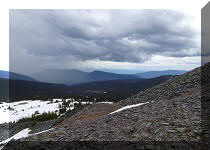
15. After eight kilometers of hiking, the forest ends, and you enter the sub-alpine. Coordinates: N 51⁰43.049' W 124⁰32.197'. Elevation: 1,900 meters (872 meters elevation gain from the start of the trail). It took us just over 2.5 hours to get here, at an average moving speed of 3.4 km/h. Here is where the easy stuff ends. First of all, there are no cairns or flagging tape of any kind. The path disappears shortly after the end of the forest. The vast marsh is about to begin. If you have no hiking boots and poles, and no GPS or good route finding skills, this is the right place to check out the view seen in the photo below, and head back.

Crazy Creek Trail - Chilcotin Hike
Here is Our Video of the Views After Reaching the Sub-Alpine:
More ihikebc videos are on our YouTube Channel.
16. We did not know where to go from here, but saw a climbable mountain straight ahead, and decided to give it a shot. Things got complicated in a hurry - the ground was marshy, so we had to hop from one dry elevated spot to another. There were numerous knee-high bushes, and our rain pants saved the day. And the mosquitoes jumped on us with reckless abandon, dying by the dozens yet never relenting in their ceaseless attacks. This was about just as bad as when we hiked Mount Murray near Barkerville. Is it possible to avoid the marsh? Hard to tell. Perhaps, going a bit to the left would have helped, but it's just a guess, as some areas were a total mini-swamp. And the trees are not an indicator of dry ground - marshy areas were all around the trees as well.

Chilcotin Hiking - Tatla Lake Hiking
17. The marsh lasted for two kilometers, and it took us one hour to get through. Here we are at the edge of the mountain seen in the photo above, and are looking back at what we have just crossed. Coordinates for this spot: N 51⁰42.411' W 124⁰33.076'. Elevation: 1,995 meters.

Tatla Lake Hike - Chilcotin Hike
18. We then started to climb the mountain. It was quite steep, made of loose rock and dirt, and the elevation was over 2,000 meters and increasing, so the oxygen was in short supply too, making for a slow go.

BC Hiking
19. Halfway through the climb, we realized that there was quite a view hiding to the left, so that's where we went.

Hike in British Columbia
Here is Our Video of the Views From Around This Area:
More ihikebc videos are on our YouTube Channel.
20. A great view indeed. Approximate coordinates for all this beauty: N 51⁰41.656' W 124⁰33.617'. Elevation: 2,194 meters.

Crazy Creek Hike near Tatla Lake British Columbia - Chilcotin Hiking
21. Looking to the right.

Hike in Chilcotin Area
22. A close-up of the most prominent peak.

Tatla Lake Hiking
23. Looking more to the right (no zoom).

Crazy Creek Hike - Chilcotin Hiking British Columbia Canada
24. And a bit more.

Tatla Lake Hiking - Crazy Creek Hike
25. Yet more to the right we see a ridge, which would have been nice to climb, if we had time.

Hike in British Columbia
26. Eventually, we returned to our original mountain, in order to cross the marsh the same way we did earlier today, in case the surrounding area would be even more complicated. A neat view on the way back.

BC Hiking
27. Finally, a look at the mountain we have to descend and the marsh beyond it. This is our highest and final point of the hike. Coordinates: N 51⁰42.114' W 124⁰33.896'. Elevation: 2,450 meters.

Chilcotin Hiking
It took us a total of six hours to get to the alpine and check all the views. Then, three hours to get back, at an average moving speed of 3.8 km/h (it's 10.7 km of hiking from the point seen in the photo above to the parking area). It is entirely possible to hike here for much longer. Provided you are properly equipped and experienced to tackle this sort of terrain, Crazy Creek hike would not disappoint. Highly recommended.
In 2020, we hiked Crazy Creek Trail one more time. Check out Crazy Creek Trail Hike Second Trip for more information and photographs.


|
 |
Other Trips in Tatla Lake BC Area:
|
|
|
|
Other Trips:


![]()


![]()
![]()
![]()
ihikebc.com Trip 159 - Crazy Creek Trail Hike (near Tatla Lake BC)