![]()
![]()
![]()

Trip 064 - July 10, 2014 (Thursday)
Slesse Memorial Trail Hike
Near Chilliwack BC Canada
Distance From Vancouver (Grandview Hwy Entrance to
Hwy 1 East):
About 130 km: 90.5 km from Vancouver (Grandview Hwy entrance to
Hwy 1 East) to Exit 119 (Yale Rd / Vedder Rd) in Chilliwack. Then 5.5 km
on Vedder Road to Chilliwack Lake Road. Then about 31 km on Chilliwack
Lake Road to Chilliwack South FSR, then less than a kilometer to
Nesakwatch FSR, then about three kilometers to the trailhead.
Liked: Picturesque river crossing, several impressive mountain views, the trail is well-marked.
Of note: Remote wilderness area. No cell phone signal. Several leg-breaking holes in the ground along the path. About 30% of the trail is badly overgrown. Hiking poles and boots are highly recommended. Long pants are recommended. The trail would be dangerous in wet conditions.
Vancouver, Coast & Mountains Backroad Mapbook (2010 edition) Coordinates: Page 5 (Chilliwack Lake) C6.
103 Hikes in Southwestern British Columbia (2008 edition): hike #70.
Other Trips in Chilliwack Area: Flora Lake Trail, Williams Ridge Trail, Mount Thom Lookout Loop Trail, Vedder Rotary Loop Trail, Teapot Hill Trail Hike, Chilliwack Dyke Trail, Greendrop Lake Trail, Mount Cheam Peak Trail, Ling Lake Trail Hike (off Chilliwack Foley FSR), Chilliwack Foley FSR, Chilliwack Bench FSR, Elk-Thurston Trail, Downtown Chilliwack BC Visit, Chilliwack Lake FSR, Radium Lake Trail, Chilliwack Lake Provincial Park, Minter Gardens, Town of Agassiz BC, Bridal Veil Falls Provincial Park.
Follow @ihikebc TweetThis was our first hike after several years, and it was a good one. Slesse Memorial Trail leads to a memorial to those who perished in 1956 in the crash of the Trans-Canada flight 810 between Vancouver and Calgary, when the aircraft smashed into Slesse Mountain. It truly is a mass grave in a very, very beautiful setting.
For detailed instructions on how to get to Chilliwack Lake Road, check out our Chilliwack Lake Provincial Park Trip Report . This time, though, you are not taking this road all the way to the Park, but, rather, look for Riverside Recreational Area on the right side about 31 kilometers after you turn onto Chilliwack Lake Road. Immediately past the Riverside Recreational Area (also on the right side) is Chilliwack South Forest Service Road (Coordinates N 49⁰04.975' W 121⁰35.167'). Take that road for a few minutes, and, after you cross several small bridges, turn right onto Nesakwatch Forest Service Road, which will take you to the Slesse Memorial Hike trailhead. It is possible to drive to the trailhead, but, unless you have high clearance, your vehicle might be damaged while crossing one of many cross ditches. Besides, there is a long steep climb right before the trailhead, so it might be a good idea to leave your vehicle on the side of Nesakwatch FSR shortly after you start driving on it, and then hike to the trailhead, which should take about an hour to an hour and a half.
1. Here we are hiking on Nesakwatch FSR shortly after 8 AM. It's much more preferable to do this hike in the first half of the day, as you would get the sun illuminating the mountains, as opposed to shining into your eyes.

Nesakwatch Forest Service Road
2. Nice mountain views on the right side of Nesakwatch FSR. Two waterfalls are there as well.

Mountain View from Nesakwatch FSR British Columbia Canada
3. A closer look at one of the mountains and a waterfall it generates.

Mountain View Seen from Nesakwatch FSR BC Canada
4. About an hour into the hike, after a long climb filled with loose stones, there is a road split. Take the road on the right, and the trailhead will be just a few minutes away.

Nesakwatch Forest Service Road British Columbia Canada
5. Ten minutes later, we are at the Slesse Memorial Hike trailhead. Coordinates: N 49⁰02.734' W 121⁰34.118'.

Slesse Memorial Trail Trailhead Nesakwatch FSR British Columbia Canada
6. At the beginning of the hike, the trail goes through a pleasant forest, and starts a gradual descent towards a river.

Chilliwack Hiking -
Slesse Memorial Trail British Columbia Canada
7. In ten minutes, there is a river crossing. This is a tricky part - the log is broken, and you would need to step on boulders too. If the river level is too high and/or the boulders and/or the log are wet, this could be a very dangerous situation.

River Crossing Slesse Memorial Trail BC Canada - Hiking in Chilliwack
Area
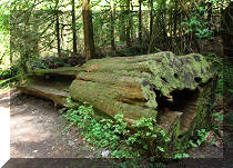
8. The broken log we used to cross the river.

Broken Log River Crossing Slesse Memorial Trail BC Canada
9. A fine view from the middle of the log.

Photo of River View Slesse Memorial Trail near Chilliwack BC Canada
10. Here we are looking back after crossing the river. This is actually another log, close to the one we used. This log can also be utilized by hikers, but it would require even more boulder hopping.

River View Slesse Memorial Trail British Columbia Canada
11. Shortly, you start hiking on an old logging road, and the trail is very badly overgrown in many parts. The good news is that the plants which cover the trail are not of the "scratching" variety, but, nonetheless, long pants and a long-sleeved shirt would be useful here, especially considering that mosquitoes would likely be a factor.

Picture of Slesse Memorial Trail British Columbia Canada
12. Sometimes, you get a break from the plants, and the trail looks like this.

Slesse Memorial Trail - BC Hiking
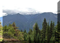
13. About an hour after crossing the river, this impressive mountain view is our first reward.

Mountain View Slesse Memorial Trail BC Canada - Hiking in British
Columbia
14. But beware - there are many leg-breaking holes along the path, and few of them are marked.

Hole in the Ground Slesse Memorial Trail British Columbia Canada
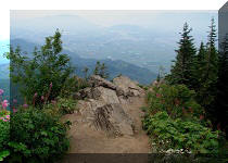
15. About twenty minutes after the first good mountain view, there is a small rockfall area, where the view gets even better.

Chilliwack Hiking - View from
Slesse Memorial Trail
16. Fifteen minutes after that, Mount Slesse Commemorative Site begins. It really felt like entering a cemetery.

Mount Slesse Commemorative Site Entrance
17. In ten minutes, we are at the memorial site, with a small monument to the victims of the crash and a plaque explaining what took place.

Mount Slesse Memorial Site
18. And, beyond the plaque, is what has to be one of the most beautiful cemeteries in the world. The airplane crashed into this mountain. The remains of 62 people have been left here - nothing had been removed after the crash due to its severity, and because of the avalanche danger. You can read about the crash on Wikipedia.

Slesse Memorial Site BC Canada
19. The monument would be a good destination for the hike, but, if you want to extend it by a few more hours, the path leads you further up.

Mount Slesse Memorial Site - Hike BC Canada
20. There are still some good mountain views, though not quite matching the ones we've already seen.

Mountain View Mount Slesse Memorial Trail British Columbia Canada
21. Here is a neat valley view, though.

Valley View Slesse Memorial Trail BC Canada
22. Zooming in.

Slesse Memorial Trail Mountain View
23. And then it's just up and up, and we got to see real snow in the middle of the Summer about an hour after the monument.

Snow Slesse Memorial Trail
23. Ten minutes later, the snow became too deep, and the trail markers were nowhere to be seen. There were likely good views above the tree line, but we did not have a chance to find out. Our final destination today was at 1,415 metres above the sea level, at coordinates N 49⁰01.761' W 121⁰34.834'.

Deep Snow Slesse Memorial Trail British Columbia Canada
It's been a good first hike of the season, with some fantastic mountain views.


|
 |
Other Trips in Chilliwack BC Area:
|
|
|
|
|
|
|
|
|
|
|
|
|
|
|
|
|
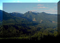
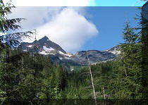
Greendrop Lake Trail
|
|
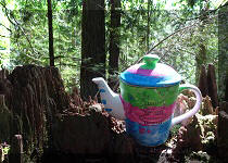
Teapot Hill Trail
|
|
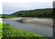
Vedder Rotary Trail
|
|
Mount Thom Trail
|
|
Flora Lake Trail  |


![]()
![]()
![]()
ihikebc.com Trip 064 -
Slesse Memorial Trail Hike (Near Chilliwack BC)