![]()
![]()
![]()

Trip 317 - August 30, 2024 (Friday)
Skyline I Trail Hike
Manning Provincial Park
Near Hope, BC
Page 1 of 2
Liked: Numerous fine mountain views, shade in the forest, few bugs, loop trail available.
Vancouver, Coast & Mountains Backroad Mapbook (2019 edition) Trailhead Coordinates : Page
7 (Manning Park) C6.Related Website: E.C.Manning Provincial Park - BC Parks official website.
Follow @ihikebc TweetSkyline I Trail is located in a huge E.C.Manning Provincial Park, found along Highway 3 East of Hope, BC. To get to the trailhead, take Gibson Pass Road from Highway 3 (Manning Park Lodge location), which is about 68 km East of Hope, and then drive to Lightning Lake Campground's Spruce Bay Beach parking lot, about 6 km from Highway 3 via Gibson Pass Road.
There is a general trailhead by the parking lot for several trails, and a connector trail leads to Skyline I trailhead in one kilometer. After that, this moderately difficult trail, which features many fine mountain views, goes up and down (mostly up) for about 9 kilometers to a junction where it connects with Skyline II Trail (which leads to Mowich camp, Hozameen Ridge junction, and, eventually, Silver Skagit Road). At this junction, if you want to come back to the parking lot, you can either turn around or proceed to complete a loop via Strawberry Flats.
*All trail distances are based on a GPS odometer and are approximate.
1. Here is a Google Maps location of Lightning Lake Campground, where a parking lot for Skyline I Trail is located.
2. We are eastbound on BC Highway 3, approximately 68 kilometers East of Hope, and are getting ready to make a right turn onto Gibson Pass Road.

BC Highway 3 at Gibson Pass Road
3. After the turn, keep left and drive towards Lightning Lakes / Strawberry Flats. Manning Park Lodge would be to the right.

Gibson Pass Road - Manning Provincial Park area
4. Upon reaching Lightning Lakes Day Area turnoff, keep going straight/right towards Lightning Lake Campground.

Gibson Pass Road at Lightning Lakes Day Area turnoff
5-6. At 5.3 km from Highway 3, arrive to Lightning Lake Campground on the left side. From here, it's 500 meters to the trails (Spruce Bay Beach parking lot).

Gibson Pass Road at Lightning Lake Campground Turnoff

Entrance to Lightning Lake Campground in Manning Provincial Park British
Columbia Canada
7. In several hundred meters, a sign indicates what's where. Keep going straight towards Spruce Bay Beach parking lot.

8-9. Arriving to Spruce Bay Beach parking lot 5.8 km from Highway 3 turnoff. Coordinates: N 49⁰03.520' W 120⁰50.451'. Elevation: 1,260 meters.


Spruce Bay Beach Parking Lot - Manning Provincial Park
10-11. Access path to several trails, including Skyline I, begins at the end of the parking lot on the left side. Cycling is not allowed.


12. Here is a map of local trails, courtesy of BC Parks. We have indicated as follows: black arrow - Highway 3, red arrow - Spruce Bay Beach parking lot, blue arrow - Skyline I Trail, green arrow - Skyline II junction, where we have turned around and went back. A PDF version of this map is here (new window).
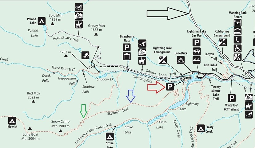
Map of Trails in Manning Provincial Park
13. The access trail is very easy. There are several turnoffs on the left side for lake access. Here we are at 440 meters from the parking lot.

Manning Provincial Park British Columbia Canada
14-15. One kilometer from the parking lot, arrive to Skyline I trailhead on the right side. Coordinates: N 49⁰03.023' W 120⁰50.409'. Elevation: 1,245 meters. It is 9 km from here to Skyline II Trail junction.


16. A word of caution.

Skyline I Trail Warning Notice
17. Skyline I Trail at 580 meters. A steady climb.

Skyline I Trail
18. A small bridge at the 1.95 km mark.

Hiking in Manning Provincial Park - Skyline I Trail
19. At 3.05 km, a featureless forest ends, and a rather unremarkable mountain view appears on the left side. At this point, the trail enters a stretch of burned trees. Here we are at 3.25 km from the trailhead.

Hiking in Manning Provincial Park - Skyline I Trail
20. At 3.57 km of Skyline I Trail in E.C. Manning Provincial Park.

Skyline I Trail Hike British Columbia Canada
21. The mountain views then start coming one after another, definitely sooner than while hiking Skyline II Trail. At 4.01 km here.

View from Skyline I Trail in Manning Provincial Park British Columbia
Canada
22. A zoomed view at the 4.28 km mark of Skyline I Trail.

Mountain in Manning Provincial Park
23. Ridge hiking at the 4.33 km mark.

Hiking in Canada - Manning Provincial Park - Skyline I Trail
24-26. A view at 4.60 km of Skyline I Trail, followed by a zoomed view and a panorama.


Panoramic View from Skyline I Trail British Columbia
27. At 4.64 km from the parking lot.

Skyline I Trail
28-29. Now at 4.75 km. Plain and zoomed.


Zoomed view from Skyline I Trail
30. A view at 4.80 km of Skyline I Trail.

Skyline I Trail Hike British Columbia
31-34. At 4.85 km, there is a major viewpoint, and this might be a good hike destination, if you do not wish to go any further. Coordinates: N 49⁰02.949' W 120⁰52.260'. Elevation: 1,940 meters (15% average grade from the trailhead). The views do not go much better going forward, and there are several pretty strenuous hills ahead, with ups and downs. Left to right, then zoomed, then a panorama.


Skyline I Trail Panoramic View
Here is our video of the views from this location.
More ihikebc videos are on our YouTube Channel.
Our Skyline I Trail Hike trip report Continues on Page 2.


|
 |
Other Trips in Hope BC Area:
|
|
|
|
|
|
|
|
|
|
|
|
|
|
|
|
|
|
|
 |
|
|
|
|
|
Eaton Peak
Route
|
Skyline II West Trail
|
Eaton Lake
Hike 2
|
|
|


Other Trips:


![]()
![]()
![]()
ihikebc.com Trip 317 - Skyline I Trail Hike (Manning Provincial Park near Hope, BC) Page 1 of 2