![]()
![]()
![]()

Trip 197 - July 27, 2020 (Monday)
Doc English Bluff Trail Hike
Near Williams Lake BC
Trailhead Location: Approximately 31 km West of the town of Williams Lake via Highway 20 (27.5 km from Hwy 97 @ Hwy 20 intersection) and Moon Road (for just over 3 km).
Liked: A very short trail to a great Fraser River view, plateau view, farm fields views, visiting a small cave, few bugs.
Of Note: Limited parking by the trailhead, Moon Rd (access road) is narrow and winding (but is in good shape), no shade on the trail, steep unbarricaded drop-offs, the cave exploration is very dangerous – for experienced and properly equipped hikers only – do not attempt descending, if the rope is worn out or damaged/compromised in any way. The ground inside the cave is very steep and is composed of loose dirt. If the rope goes, or you let go of the rope, it’s a guaranteed slide to the drop-off, and then at least a 15-meter free fall to the top of a pile of large stones. Hiking poles and boots are highly recommended for the trail. Hiking boots are essential for cave descent.
Cariboo Chilcotin Coast BC Backroad Mapbook (4th edition) Trailhead Coordinates: Page 16 (Gang Ranch) G1.
Related Website: Doc English Bluff Ecological Reserve - BC Parks Official Website.
Doc English Bluff is made of limestone, and is located inside an ecological reserve, about 31 kilometers West of Williams Lake via Highway 20 and Moon Road. The bluff is a prominent landmark better observed from the side of Highway 20. There is a very short trail (less than two kilometers round-trip) to the top of the bluff, leading to an impressive view of Fraser River, as well as of a nearby plateau. Also, there is an interesting small cave by the trail, but the descent is so steep that the rope is required. It's a dangerous area better left for experienced and properly equipped hikers. The upper part of the trail is a loop (albeit a very short one). Watch for steep unbarricaded drop-offs while hiking this trail.
1-2. We hiked Doc English Bluff after visiting Farwell Canyon (subject of the previous trip report), so we were driving East on Highway 20 (towards Williams Lake) and stopped at a pullout approximately 700 meters before Moon Road. Here is a view (actual and zoomed) of Doc English Bluff from this location.


Doc English Bluff near Williams Lake British Columbia Canada
3. We went past Moon Road, turned around, and now we are on Highway 20 Westbound (from Williams Lake) with Moon Road turnoff seen on the left side. Coordinates: 51⁰57.846’ W 122⁰17.313’. Elevation: 598 meters. It's 27.5 km from Highway 97 @ Highway 20 intersection in Williams Lake, and 2.5 km from the end of Fraser River bridge on Highway 20.

BC Highway 20 Westbound at Moon Road Turnoff near Williams Lake
4. Moon Road immediately after turning from Highway 20. There is a cattle guard shortly after the turn.

Moon Road British Columbia
5. Moon Road is narrow and winding, but is in good shape. It leads to a farm, after passing by the trailhead parking area.

Moon Road near Williams Lake BC
6. A farmer at work.

Farmer Working near Williams Lake British Columbia Canada
7. Narrow and winding Moon Road. Doc English Bluff seen ahead on the left side.

Moon Road BC Canada
8. After passing another cattle guard at 3.1 km, the left turn leads to the trailhead parking area.

Moon Road near Doc English Bluff Trailhead Parking
9. Doc English Bluff trailhead parking area. Coordinates: N 51⁰56.369’ W 122⁰16.583’. Elevation: 652 meters.

Doc English Bluff Ecological Reserve Parking
10. A short path leads to the trailhead at the far end of the parking lot.

Doc English Bluff Ecological Reserve near Williams Lake British Columbia
Canada
11. A fallen sign speaks of the ecological reserve.

Doc English Bluff Ecological Reserve Information
12. Doc English Bluff Trail starts very steeply.

Doc English Bluff Trail - Williams Lake Trail
13. After 200 meters or so, the trail becomes substantially easier to hike.

Williams Lake Hike - Doc English Bluff Trail
14. A good view of Moon Road (leading to a farm) appears shortly on the right side.

Moon Road seen from Doc English Bluff Trail - Williams Lake Hiking
15. The trail continues, and becomes even easier the higher you get. Approximately 325 meters from the start of the hike, the upper loop begins. We went to the right. It took less than 700 meters to complete the loop. The entire trail is under 2 km round-trip.

Hike in Williams Lake Area - Doc English Bluff Trail
16. The drop-offs are steep and unbarricaded indeed.

Doc English Bluff near Williams Lake British Columbia Canada
17. Just a bit further...

Trail in Williams Lake Area - Doc English Bluff Trail
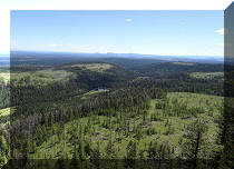
18...and a great Fraser River view is straight ahead. Coordinates: N 51⁰56.451’ W 122⁰16.515’. Elevation: 726 meters (74 meters elevation gain from the start of the trail).

Fraser River seen from Doc English Bluff Ecological Reserve near
Williams Lake BC
Here is our video of the views from this point.
19-21. A plateau on the right side is very fine as well. Left to right.


View from Doc English Bluff near Williams Lake British Columbia Canada
22. The hike continues.

Doc English Bluff Trail - Hiking in Williams Lake Area
23. Shortly after the river view, there is a cave in the ground.

Cave on Doc English Bluff
24. WARNING - DANGEROUS AREA. The cave exploration is very dangerous – for experienced and properly equipped hikers only. Do not attempt descending, if the rope is worn out or damaged/compromised in any way. The ground is very steep and is composed of loose dirt at the bottom. If the rope goes, or you let go of the rope, it’s a guaranteed slide to the drop-off, and then at least a 15-meter free fall to the top of a pile of large stones. Hiking boots are essential for cave descent.

Cave in Doc English Bluff Ecological Reserve - British Columbia Cave
25. We used the rope attached to the tree to descend about 20 meters to a small natural platform near the drop-off/edge.

Cave in Williams Lake Area on Doc English Bluff
26. Here we are looking back from the end of the descent.

Cave in British Columbia
27. Now looking down from the end of the descent. The rope does NOT go all the way to the stones below - the end of the rope hangs in mid-air.

British Columbia Cave near Williams Lake
28. Here is the view of the "observation platform" at the end of the descent (illuminated by the sun in the middle of the photograph) and the view of the hanging rope. It's very steep down there, and the ground is quite loose.

Doc English Bluff Cave
29. We took the photo above from the top "window" of the cave, which can be reached by hiking on the trail past the cave entrance. Here we are looking up from the end of the descent towards that top "window". There are a few other "windows" there as well.

30. And here is the view of the top "window" from the outside.

Cave in Doc English Bluff Ecological Reserve British Columbia Canada
Here is our video inside the cave.
More ihikebc videos are on our YouTube Channel.
31. Having finished the hike, we are now driving towards Williams Lake. Here is that bridge across Fraser River, seen in the first video. It's 2.5 kilometers from the end of the bridge (if driving from Williams Lake) to the Moon Road turnoff on the left side.

BC Highway 20 Fraser River Bridge near Williams Lake British Columbia
Doc Bluff trail is very short, and leads to a great view of Fraser River, and a neat (if dangerous) small cave. Highly recommended.


|
 |
Other Trips in Williams Lake Area:
|
The Dome Trail Hike
|
|
Other Trips:


![]()
![]()
![]()
ihikebc.com Trip 197 - Doc English Bluff Trail Hike (Near Williams Lake BC)