![]()
![]()
![]()

Trip 144 - August 17, 2018 (Friday)
Glacier Gulch Trail Hike
Near Smithers, BC
Location: Off BC Highway 16, near the town of Smithers.
Liked: Easy access to the trailhead, mountain / valley / river views, shade in the forest, no bugs.
Of Note: Glacier Gulch trail is dangerous, and is for experienced well-equipped hikers only. The last two thirds of the trail is loose rock and dirt, with numerous opportunities to get hurt. Hiking boots and poles are essential. Specialized equipment and training are needed to access the glacier.
Northern BC Backroad Mapbook (3rd edition) Trail Coordinates: Page 35 (Moricetown) G5.
Glacier Gulch Trail starts off Twin Falls Recreation Site, located off BC Highway 16, slightly West of the town of Smithers. This recreation site is quite popular, as a short walk leads to an observation platform with a good view of an impressive waterfall. On the way to the observation platform, a path on the left side signals the beginning of Glacier Gulch Trail, which leads to a glacier on top of Hudson Bay Mountain. Glacier Gulch Trail features several very impressive views, and is not excessively steep. That said, it's one of the most dangerous trails we have hiked, as the last two thirds of this trail is almost nothing but large loose rock and dirt, and hiking poles and boots, especially on the way down, are absolutely essential. You may want to avoid this trail, if the ground is slippery or wet.
1. We are Westbound on BC Highway 16, leaving the town of Smithers. Zero your odometer as you are driving past these statues of a horse and a bear.

BC Highway 16 at the Western end of Smithers
2-3. Turn left onto Lake Kathryn Road 2.3 km past the statues. The sign would point to Twin Falls Recreation Site.


BC Highway 16 West at Lake Kathryn Road Turnoff
4. At the 4.7 mark, turn left onto Glacier Gulch Road. It becomes gravel at 6.4 km after the statues. A railroad crossing is required.

Lake Kathryn Road at Glacier Gulch Road Turnoff by Smithers BC Canada
5. Arrive to Twin Falls Recreation Site with 8.8 km on the odometer. Pit toilet and garbage bins are available, as well as a few level sites. Maximum allowed stay is 14 consecutive days. The trail starts just past the pit toilet seen ahead. Recreation site coordinates: N 54⁰49.533' W 127⁰16.561'. Elevation: 746 meters.

Twin Falls Recreation Site near Smithers British Columbia Canada
6. The beginning of the Twin Falls and Glacier Gulch trails.

The path to Glacier Gulch Trailhead off Twin Falls Recreation Site by
Smithers BC
7. A few hundred meters later, there is a split. Glacier Gulch Trail starts to the left of the information board. To the right is a very short trail to Twin Falls observation platform.

Glacier Gulch Trailhead by Smithers BC Canada
8. The first one third of the Glacier Gulch Trail is fairly easy.

Smithers Hiking - Glacier Gulch Trail to Hudson Bay Mountain Glacier
9. There is a steady elevation gain, with tree roots and firmly planted stones being the major obstacles. Shade and no bugs make the hike even better.

Glacier Gulch Trail - hiking in Smithers BC area
10. The right side of Hudson Bay Mountain starts appearing very shortly.

Hudson Bay Mountain seen from Glacier Gulch Trail - Smithers Hike
British Columbia Canada
11. Fifty minutes into the hike, right after this warning sign, things change dramatically. The path turns into loose stones and dirt, and the views get better and better. Approximate coordinates for this point: N 54⁰49.116' W 127⁰17.092'. Elevation: 1,187 meters.

Hike in Smithers BC area - Glacier Gulch Trail - Mountain Hazards
Warning Sign
12. The path after the sign. It disappears and reappears on several occasions, but the general direction of travel is obvious.

Trail in Smithers Area - Glacier Gulch Trail to Hudson Bay Mountain Glacier
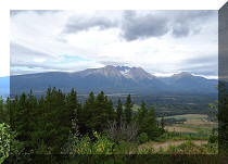
13. The higher you climb, the better are the views of Bulkley Valley behind you.

Bulkley Valley seen from Glacier Gulch Trail - Smithers Trail - British
Columbia Hiking
14. You also start seeing the mountain river flowing from the Hudson Bay Mountain glacier.

Glacier Gulch Trail by Smithers - Trail in BC Canada
15. It is possible to get right up to the river after the first half of the trail.

Mountain River by Glacier Gulch Trail - hiking in Smithers Area -
British Columbia Canada
16. Looking forward and to the left.

View from Glacier Gulch Trail near Smithers BC - Canada Hiking
17. One more look at the valley behind us.

Bulkley Valley View from Glacier Gulch Trail by Smithers British
Columbia - Hike in Canada
18. And now we are by the edge of the mountain river.

Mountain River by Glacier Gulch Trail - Smithers area hiking
Here is Our Video of the Views from This Area:
More ihikebc videos are on our YouTube Channel.
17. Looking to the right.

View from Glacier Gulch Trail by Smithers BC Canada
18. Now looking back, with the valley and the river seen together.

Bulkley Valley and Mountain River seen from Glacier Gulch Trail near
Smithers BC
19. An inukshuk is observing the valley.

Inukshuk on Glacier Gulch Trail - Smithers area hiking
20. About two hours after the start of the hike, the glacier itself comes into view.

Hudson Bay Mountain Glacier by Smithers BC Canada
21. How long it would take to reach the glacier would depend on the time of the year - it obviously gets smaller by the end of Summer. Here we can see the edge of the glacier where the mini-lake begins in the middle of the photo. Coordinates: N 54⁰48.942' W 127⁰17.992'. Elevation: 1,550 meters (804 meters elevation gain from the start of the hike). It took us about 2 hours and 15 minutes to get here (a distance of approximately 3.4 km), with an average moving speed of 2.1 km per hour.

Hudson Bay Mountain - Smithers hiking - Glacier Gulch trail
22. While specialized equipment and training are required to safely hike on the glacier, we went just a bit forward, as the glacier near its edge was covered with numerous stones, making traction easy. That said, it's a risky proposition, considering the melting season.

Hudson Bay Mountain glacier near Smithers British Columbia
23. The glacier itself underwhelmed. It sure looks better from across the valley.

Hudson Bay Mountain by Smithers BC
24. Here is a view of the same glacier from Harvey Mountain Trail, which we hiked several days ago.

Hudson Bay Mountain near Smithers BC seen from Harvey Mountain Trail
25. Zoomed-in view of Hudson Bay Mountain glacier.

Hudson Bay Mountain Glacier near Smithers British Columbia Canada
Glacier Gulch trail is a dangerous hike, and should be left for experienced well-equipped hikers. Provided you know what you are doing, this trail is definitely recommended for very fine views of the mountains, river, and the valley.


|
 |
Other Trips in Smithers BC Area:
|
|
|
|
|
|
|
|
|
|
|
|
|
Fletcher-Gardiner Trail  |
Other Trips:


![]()


![]()
![]()
![]()
ihikebc.com Trip 144 - Glacier Gulch Trail Hike (near Smithers BC)