![]()
![]()
![]()

Trip 053 - August 3, 2011 (Wednesday)
Squamish River FSR - Ashlu Main & A-600
Page 1 of 2
Distance From Vancouver to the Beginning of Ashlu Main
FSR:
About 99 km - 65 km via Highway 99 (Sea-to-Sky) North to
Squamish Adventure Centre, then keep driving straight on Highway 99 and
turn left onto Squamish Valley Road 9.6 km later, then drive for 23 km
to Squamish River FSR, and turn left onto Ashlu Main 1.2 km after that.
Liked: Decent road surface until the end of 2WD road for both Ashlu Main and A-600 branch road, several good natural views, dam view (Ashlu Main), shadow in the forest while walking on both Ashlu Main and A-600.
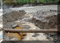
Of note: Not too many mosquitoes but numerous annoying flies, very few views while walking on Ashlu Main for several hours past the dam (where the 2WD road ends).
Vancouver, Coast & Mountains Backroad Mapbook (2010 edition) Coordinates for the Beginning of the FSR: Page 21 (Phantom Lake) G2.
Related Website: Squamish District FSR Conditions.
Subsequent Trip: Squamish River FSR Ashlu Main Second Trip.
Nearby FSR Trips: Squamish River Main, Squamish River Ashlu, Squamish River E-Main, Squamish River FSR Washout.
Other Forest Service Roads Trips: Chehalis (by Harrison Mills), Chilliwack Bench, Chilliwack Foley, Chilliwack Lake, Chuchinka-Colbourne (North of Prince George), Clear Creek (off Harrison East), Florence Lake (access to Stave Lake by Mission), Harrison East, Harrison East Second Trip, Harrison West, Jones Lake (near Hope), Lost Creek (by Mission), Mamquam River (by Squamish), Nahatlatch (near Boston Bar), Parsnip West (by Mackenzie), Scuzzy (by Boston Bar), Shovel Creek (off Harrison East), Sowaqua Creek (by Hope), Windfall Creek (by Tumbler Ridge).
Follow @ihikebc Tweet
We have previously visited the rest of the main branches of Squamish River Forest Service Road (S-Main and E-Main), and this time we checked out the remaining A-Main (Ashlu) FSR. It was not nearly as picturesque as the rest of the FSRs. However, we checked just a bit of A-Main FSR, as the 2WD road ends very soon, and then you either need to have a bicycle, or ATV (better), or walk. We walked for a few hours, saw almost no good views past the end of the 2WD road, turned around and went back. That said, there were still good views to be had along the 2WD road, including on A-600 branch.
For those interested in camping, there is a free campground by Squamish River just after you cross the bridge after turning onto Ashlu FSR. The photos of that are below. There are also good flat camping spots along Ashlu Main and A-600.
2014 Update: find out what we discovered during our Second Ashlu Main Trip.
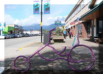
1. The directions to Ashlu Main from Vancouver are as follows. Take Highway 1 and drive West to Highway 99 (Sea-to-Sky). Then drive to Squamish. Here we are in Squamish near Squamish Adventure Centre (seen on the right side).

BC Highway 99 (Sea-to-Sky) Near Squamish Adventure Centre
2. Having passed the Squamish Adventure Centre, keep driving for almost ten more kilometers North. Lots of good views.

Highway 99 North (Sea-to-Sky) in Squamish British Columbia Canada
3. At the 9.6 km mark past Squamish Adventure Centre, turn left onto Squamish Valley Road. Turning right at this intersection would lead to Alice Lake Provincial Park.

Highway 99 at Squamish Valley Road Province of BC Canada
4. Then, drive on Squamish Valley Road for the next 22 kilometers. Our more detailed coverage of this road is here (two very impressive glaciers are down that way).

Squamish Valley Road British Columbia Canada
5. Cross a bridge at the 13 km mark of Squamish Valley Road, and then there is a split. Stay left, as on the right side is the beginning of Paradise Valley Road.

Paradise Valley Road at Squamish Valley Road BC Canada
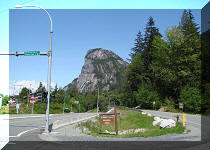
6. After the split pictured above, Squamish Valley Road is very winding with limited passing opportunities, and caution is needed. Close to 23 km after turning left from Highway 99, the asphalt ends, and gravel Squamish River Forest Service Road begins.

Squamish River Forest Service Road
7. Just 1.2 km later, turn left onto Ashlu Main FSR. Going straight is S-Main, and further ahead on S-Main are turnoffs to G-Main and E-Main.

Ashlu Main Split with Squamish River Forest Service Road Province of BC
Canada
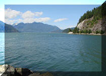
8. Upon turning left, you are crossing this bridge across Squamish River.

Bridge Across Squamish River - Ashlu Main FSR
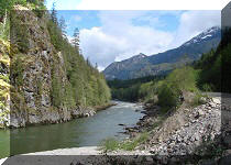
9. The view from the bridge. Looking right.

Squamish River Province of British Columbia Canada
10. Very soon after crossing the bridge, there is a free campground with nine pads. No services, no garbage removal. Two pit toilets, but no toilet paper provided. A small beach is there too. This is called Riverside Recreation Site.

Entrance to Free
Camping
at Ashlu Main Forest Service Road
11. Here is the map of Riverside Recreation Site.

Squamish Riverside Campsite Map
12. One of the camping spots at Riverside Campsite. If all the camping spots are taken here when you come, just drive further on Ashlu and find a flat spot on the side - there are a few.

Free
Camping
at Squamish Riverside Campsite off Ashlu Main FSR Province
of BC
13. The map shows a good beach access. But there was someone camping near that access, and we did not want to disturb them. So, we found another way to get to the beach, more suitable for a gymnast, as it requires a balancing act.

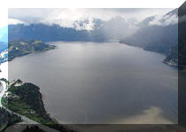
14. But then you are rewarded with a decent sand beach and good views.

Beach at the Squamish Riverside Free Campsite
15. Looking the other way.

Squamish River seen from the Free Campsite off Ashlu Main Forest Service
Road Province of BC Canada
16. And check this out - someone had collected the broken glass. Thank you!

17. Now we are going further on Ashlu Main. 2.4 km after turning onto Ashlu from Squamish River FSR S-Main, on the left side you see a branching road. This is where Sigurd Creek / Sigurd Peak trail begins. It is a challenging trail, which leads to a very impressive waterfall. Or, you can proceed to the Sigurd Peak, but that trail is very tough. We will describe all of that in our next trip report.

Ashlu Main FSR at Sigurd Creek Trailhead
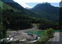
18. At 2.7 km, there is a powerhouse. A dam is further down the road.

Ashlu FSR Powerhouse
On the next page, we explore A-600 branch road with its old bullet-ridden buildings, as well as hike down Ashlu Main past the end of the 2WD road.


|
 |
Other Trips in Squamish Area:
|
|
|
|
|
|
|
|
|
|
|
|
|
|
|
|
|
|
|
|
|
|
Mamquam River FSR
|
|
|
Seed Peak Trail
|


Other Trips:


![]()


![]()
![]()
![]()
Follow @ihikebc Tweet
ihikebc.com Trip 053 - Squamish River FSR Ashlu Main Page 1 of 2