![]()
![]()
![]()

Trip 049 - July 19 and 21, 2011 (Tuesday and Thursday)
Harrison East Forest Service Road Trip
To about the 68 km mark, somewhat close to the end of the road
Page 1 of 3
Big changes
for Harrison East -
click here for 2015 trip report
Distance From Vancouver:
About 130 km to the beginning of the FSR via
Highway 1 East (to Exit 135), then Highway 9 North (to
Harrison Hot Springs),
and Lillooet Avenue / Rockwell Drive.
Of note: Logging trucks in the area, no cell phone reception, brutal mosquitoes.
Vancouver, Coast & Mountains Backroad Mapbook (2010 edition) Coordinates for the Beginning of the FSR: Page 14 (Harrison Lake) G7.
Related Website: Chilliwack District FSR Conditions.
Subsequent Trip: 077 - Harrison East FSR Second Trip.
Other Forest Service Roads Trips: Chehalis (by Harrison Mills), Chilliwack Bench, Chilliwack Foley, Chilliwack Lake, Chuchinka-Colbourne (North of Prince George), Clear Creek (off Harrison East), Florence Lake (access to Stave Lake by Mission), Harrison West, Jones Lake (near Hope), Lost Creek (by Mission), Mamquam River (by Squamish), Nahatlatch (near Boston Bar), Parsnip West (near Mackenzie), Scuzzy (by Boston Bar), Shovel Creek (off Harrison East), Sowaqua Creek (by Hope), Squamish River Main, Squamish River Ashlu, Squamish River E-Main, Squamish River FSR Washout, Windfall Creek (by Tumbler Ridge).
>>> British Columbia Waterfalls Visits.
Harrison East Forest Service Road runs for about 22 kilometers along the East side of Harrison Lake, and then diverts into some of the finest Southwestern BC wilderness. We have driven to the split with Shovel Creek Forest Service Road (58.4 km mark), and decided to drive further on Harrison East. But that's where the numerous cross-ditches began to appear, and we got badly stuck far away from the nearest human being. Thank God for Tow Truck in a Box - we got out! We then drove on Shovel Creek FSR, hiked an unnamed FSR the next day (Wednesday), and then on Thursday returned to the split and hiked Harrison East close to the end, or about 70 km mark.
The first two pages of this trip report describe our Tuesday adventure, and the third page is dedicated to the Thursday hike. Shovel Creek FSR trip report follows Harrison East FSR trip report. During all of our trip, low-hanging clouds concealed much of the surrounding wilderness, plus the rain was fairly frequent. In sunny weather you are likely to see even more.
On July 5, 2011, we have visited a substantially less impressive Harrison West FSR.
Here is the table of points of interest along Harrison East FSR. Zero your odometer at the sign seen in the photo #9 below. Please, note, that the yellow mileage markers on the road do not exactly correspond to the mileage in the table, the difference usually being around 300-500 meters. All recreation sites carry a $13 charge per night.
| KM | Feature | Side |
| 4.9 | Slollicum FSR (active logging) | Right (R) |
| 6.7 | Rainbow Falls (photo below) | R |
| 8.7 | Harrison Lake lookout | Left (L) |
| 11.2 | Cascade Peninsula Recreational Site | L |
| 14.0 | Harrison Lake view opens up and continues | L |
| 15.0 | Small Waterfall (photo below) | R |
| 15.1 | Bear Creek Recreational Site | L |
| 18.5 | Small Waterfall (photo below) | R |
| 20.2 | Cogburn Beach recreation site (1.6 km long) | L |
| 23.8 | Road (FSR?) | R |
| 24.3 | Road (FSR?) | R |
| 28.0 | Camping spot | L |
| 31.3 | Active Logging Camp (Tamihi Logging Company) | L+R |
| 32.5 | Steep road (FSR?) | R |
| 34.6 | Hornet Creek FSR | R |
| 35.1 | Pine Mainline FSR | R |
| 36.9 | Clear Creek FSR (trip #076) | R |
| 39.2 | Camping spot | L |
| 42.0 | Road Gets Substantially Rougher | Straight |
| 42.9 | Road Split - Harrison East is to the Right | - |
| 46.0 | Very large camping area (photo on page 2) | L |
| 47.9 | Bridge over Gold Creek (photo on page 2) | Straight |
| 58.4 | Shovel Creek FSR | R |
| 58.4 | End of 2WD Road for Harrison East FSR | Straight |
1. We are on Highway 1 East around Chilliwack, en route to Exit 135.

TransCanada Highway 1 East Around Chilliwack BC
2. Take Exit 135 and follow signs to Agassiz and Harrison Hot Springs (via Highway 9 North). The photo below shows a bridge over Fraser River shortly before Agassiz. You can also get to Harrison Hot Springs from Vancouver via Highway 7.

Highway 9 Bridge Across Fraser River near Agassiz BC Canada
3. Now we are in Agassiz, following signs to Harrison Hot Springs (still Highway 9 North).

Photo of Agassiz British Columbia Canada
4. Upon arrival to Harrison Hot Springs, keep driving on the same road until Lillooet Avenue (one block before Harrison Lake).

Harrison Hot Springs BC Canada
5. At the intersection of Highway 9 (also called Hot Springs Road) and Lillooet Avenue is a Husky Gas Station - your last chance to fill up the gas tank before heading into the wilderness.

Village of Harrison Hot Springs British Columbia Canada
6. Turn right onto Lillooet Avenue. It is 7.4 kilometers from here to the beginning of Harrison East FSR.

Hot Springs Road at Lillooet Avenue Harrison Hot Springs BC Canada
7. Lillooet Avenue turns into Rockwell Drive, which is a fairly narrow, winding road with a 40 km/h speed limit. This is also the way to Bear Mountain Hiking Trail.

Rockwell Drive Harrison Hot Springs
8. Arriving to a split 7.4 kilometers after turning onto Lillooet Avenue. To the right is a road to Deer Lake and Hicks Lake camping areas. To the left is the beginning of Harrison East Forest Service Road.

Harrison East FSR Entrance Province of British Columbia Canada
9. The signs at the beginning of Harrison East FSR advise of the following: all three campgrounds charge $13 per night, and the logging company radio frequency is 152.090. Zero your odometer here, if you want to follow the table of points of interest at the top of this page.

Harrison East Forest Service Road Entrance Signs
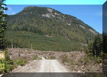
10. Harrison East is a VERY smooth FSR all the way to the 42 km mark. The road is also fairly wide and with few dangerous turns. You can safely maintain the speed of 50-60 km/h most of the time.

Harrison East FSR Picture
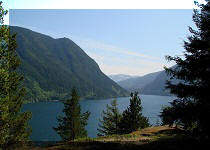
11. And you don't have to wait long for good lake views. This one arrives shortly after the 2 km mark.

Harrison Lake Seen From Harrison East FSR BC Canada
12. One of the most impressive waterfalls along Harrison East FSR is Rainbow Falls, seen from the bridge at the 6.7 km mark.

Rainbow Falls Harrison East FSR British Columbia Canada
13. Rainbow Falls close-up.

Rainbow Falls Harrison East Forest Service Road
Here is our video of Rainbow Falls:
More ihikebc.com videos are on our YouTube Channel.
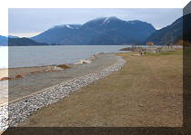
14. Another good lake view is at the 8.7 km mark of Harrison East.

Harrison Lake Province of British Columbia Canada
15. Yet another decent Harrison Lake view is at the 14.0 km mark, where the lake opens up, and you are starting to drive with a good view of the lake by your side for over a kilometer.

Harrison Lake BC Canada
16. Still smooth. Still wide.

Harrison East Forest Service Road
17. The next waterfall awaits near Bear Creek Recreation Site around the 15 km mark.

Waterfall Harrison East FSR British Columbia Canada
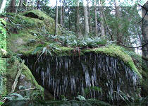
18. Another one is on the right side of the road 3.5 kilometers later.

Harrison East FSR Waterfall Province of BC Canada
Our Harrison
East
FSR Trip Report
Continues on
Page 2.


|
 |
Other Trips in Harrison Hot Springs Area:
|
|
|
|
|
|
|
|
|
|
|
|
Other Trips:


![]()


![]()
![]()
![]()
Follow @ihikebc Tweet
ihikebc.com Trip 049 - Harrison East FSR Page 1 of 3