![]()
![]()
![]()

Trip 116 - August 13, 2016 (Saturday)
Battleship Mountain Trail Hike
Near Hudson's Hope BC
Trailhead Location: Northeastern British Columbia, approximately 55 km West of Hudson's
Hope.
Liked: Shade in the forest, almost no bugs (except at the peak), several good mountain and lake views.
Of note: Access road has few potholes but lots of loose and slippery gravel (watch out when cornering); there are several long steep stretches - hiking boots and poles are highly recommended; the final ascent to the peak is very steep and is for experienced hikers only - hiking poles and boots would be essential; the trail is slightly overgrown with stinging plants in some places - long pants are recommended; there are signs of logging activity along the access road.
Northern BC Backroad Mapbook (3rd edition) Battleship Mountain Coordinates: Page 65 (Hudson's Hope) D6.
The directions to Battleship Mountain Trail are as follows: get to the town of Hudson's Hope on BC Highway 29 between Chetwynd and Fort St. John. Follow signs to W.A.C. Bennett Dam, which means driving on Canyon Drive for 20 kilometers. Go past the dam Security gate (guards will record your vehicle's license plate and your driver's license information). Go past the turnoff to the dam Visitor Centre and then make two consecutive right turns to get to the dam. Cross the dam. Four kilometers past the dam Security gate starts Utah Road. Six and a half kilometers later keep straight at the intersection (the road is now called Table Rd). Just under two and a half kilometers later, make a sharp right turn onto Johnson Road. Drive 23.4 kilometers on Johnson Road to the trailhead, which will be 1.3 km past Carbon Lake Recreation Site. Or, according to a brochure provided by Hudson's Hope visitor centre, you can take Johnson Road from Highway 29 and arrive to the trailhead 64 kilometers later, but we did not test that route.
***Somehow, our trip to the trailhead from the beginning of Utah Rd took 32.3 km, while the return trip took only 29.8 km. To complicate the matters, the hiking trails brochure from the Hudson's Hope Visitor Centre states that it takes 28 km upon turning onto Johnson Road to reach the trailhead, which would make the total distance from the dam road almost 37 km. However, as long as you remember to keep straight when Utah Rd becomes Table Rd, and make a sharp right turn when Table Rd meets Johnson Rd, you will find the trailhead.
1. We start with the turnoff to Utah Rd from the road which took us across the W.A.C. Bennett Dam. The sign by the turnoff indicates that this is the way to Carbon Lake and Battleship Mountain. The photo below is taken from the same point as photo #25 in the W.A.C. Bennett Dam trip report. Check out that trip report for directions up to this point, and then take Utah Rd when you get to this point.

Start of Utah Rd by W.A.C. Bennett Dam
2. Now on Utah Road.

Utah Road near Hudson's Hope BC Canada
3. Keep going straight at the split at the 6.5 km mark, seen below. You would be driving on Table Road after the split.

Utah Road at Table Road near Hudson's Hope British Columbia
4. Make a sharp right turn onto Johnson Road 2.4 kilometers later.

Table Road at Johnson Road near Hudson's Hope BC Canada
5. Drive for over 20 km on Johnson Road, and you would reach Carbon Lake Recreation Site.

Johnson Road at Carbon Lake Recreation Site near Hudson's Hope British
Columbia
6. There is a short steep road to the recreation site, which is very small, but has a good lake view.

Carbon Lake near Hudson's Hope British Columbia
7. Now this is for certain: 1.3 km after Carbon Lake Recreation Site is Battleship Mountain trailhead, with parking space available by the sign. Coordinates: N 55⁰57.308' W 122⁰35.893'. Elevation: 925 meters.

Johnson Road at Battleship Mountain trailhead
8. Off we go.

Battleship Mountain Hike - Hudson's Hope Trail BC Canada
9. Lots of shade in the forest, which was good on this warm day.

Battleship Mountain trail - Hudson's Hope Hiking
10. The trail is a bit overgrown in some parts, however, with stinging plants waiting to hurt those who did not put their long pants on.

Overgrown Battleship Mountain trail - Hudson's Hope Hike
11. Having survived stinging plants, more than an hour into the hike you get to see a body of water, which, as one of our readers suggested, is an arm of Williston Lake.

Williston Lake arm seen from Battleship Mountain trail - Hike in
Hudson's Hope Area
12. The trail continues.

Battleship Mountain trail in Northeastern British Columbia Canada -
Hiking in Hudson's Hope Area
13. Half an hour later arrives the first lake. The hiking brochure states that the trail leads to Little Carbon Lake, but there is another lake further on, so we couldn't quite tell which lake was called what, though it is likely that Little Carbon Lake is the second lake.

Lake by Battleship Mountain trail - BC Hiking
14. Hike a bit further...

Battleship Mountain Hike - Trail in Hudson's Hope Area
15. ...and here is the second lake, with Battleship Mountain now visible too.

Battleship Mountain seen from the second lake by the trail - BC Trail
16. This trail gains altitude quite steadily, with some rather steep stretches. However, along the lakes the trail is mostly flat, giving a welcome break before you emerge out of the woods to this view of the second lake on your left. Coordinates at this important point (because flagging becomes sporadic after this) are N 55⁰59.159' W 122⁰36.026'. Elevation: 1,522 meters.

Second lake seen from Battleship Mountain trail - BC Hike
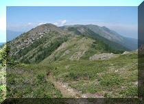
17. Now we are looking to the right. The first part of the ridge hike is not too hard.

Battleship Mountain - Hiking in British Columbia Canada
18. There are neat views every now and then.

View from Battleship Mountain trail - British Columbia Hiking
19. But, soon, the easy stuff is over, and the real grunt is about to begin. The trouble is that there was no flagging and no obvious way up, as, despite the appearance in the photo below, the mountain is too steep to tackle it head on, so we zigzagged our way mostly on the right side, but you would need to figure things out as you go. As mentioned above, the final ascent is for experienced, well-equipped hikers only. That's not yet the peak, by the way.

Battleship Mountain near Hudson's Hope British Columbia Canada Hiking
20. Found this neat stone in the alpine.

Stone on Battleship Mountain - Hudson's Hope Hike
21. And now the peak is near.

Battleship Mountain - Hike in British Columbia
22. Here it is. Coordinates: N 55⁰59.721' W 122⁰36.128'. Elevation: 1,846 meters (921 meters elevation gain from the start of the trail). There were hundreds of overly friendly flies at the peak, but, otherwise, the trail was pleasantly almost bug-free.

The peak of Battleship Mountain - Hudson's Hope Hiking
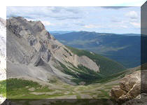
23. The views from the peak of Battleship Mountain are hardly spectacular, but not bad either.

View from the peak of Battleship Mountain in Northeastern British
Columbia - Canada Hiking
24. One more.

View from the peak of Battleship Mountain near Hudson's Hope BC Canada
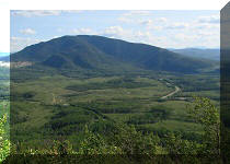
25. And the view of the second lake.

Second lake seen from the top of Battleship Mountain
It took us about 4 hours to get to the top, and close to 2.5 hours to return. While not the greatest hike in the Peace region, Battleship Mountain has some good views, and certainly qualifies as a serious workout.


|
 |
Other Trips in Hudson's Hope BC Area:
|
|
|
|

![]()
![]()
![]()
ihikebc.com Trip 116 - Battleship Mountain Trail Hike (near Hudson's Hope BC)