![]()
![]()
![]()

Trip 024 - May 11, 2010 (Tuesday)
Shannon Falls Visit
Near Squamish BC
Distance From Vancouver: 60 km via Highway 1 West and Highway 99 (Sea-to-Sky) North.
Liked: Very impressive waterfall. Short walk from the parking area.
Of note: Shannon Falls is a popular attraction.
Vancouver, Coast & Mountains Backroad Mapbook (2010 edition) Coordinates: Page 22 (Squamish) C7.
Related Website: Shannon Falls Provincial Park - BC Parks Official Site.
>>> British Columbia Waterfalls Visits.
Follow @ihikebc Tweet
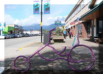
Shannon Falls is a popular attraction on the East side of Highway 99 (Sea-to-Sky), just five kilometers South of Squamish. You can also hike to The Stawamus Chief from the Shannon Falls parking lot.
1. We are on Highway 99 (Sea-to-Sky), looking South. Squamish is five kilometers behind us, and we are waiting for the green light to turn left to enter Shannon Falls Provincial Park.

Highway 99 Sea-to-sky British Columbia Canada
2. Having turned left, we see the entrance to the park, as well as The Stawamus Chief ahead.

Entrance to Shannon Falls Provincial park
3. The parking lot is quite large, and can even accommodate several buses. Park you car and head up this path.

Shannon Falls Provincial Park
British Columbia Canada
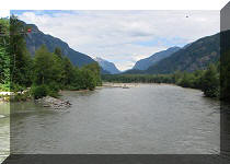
4. Shannon Creek keeps you company along the way.

Shannon Creek near Squamish BC Canada
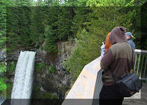
5. The waterfall appears very shortly, and happy tourists have their photos taken all over.

Tourists in front of Shannon Falls
British Columbia Canada
6. Here is a look at Shannon Falls from the first and most popular viewing platform, located five minutes away from the parking lot.

Shannon Falls
7. If you want to have a better and more private look, head up the stairs to your left.

Shannon Falls Provincial Park
British Columbia Canada
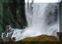
8. Very soon, Shannon Falls is even closer.

Shannon Falls near Squamish BC
Here is our video of Shannon Falls:
More ihikebc.com videos are on our YouTube Channel.
9. That's it for established viewing platforms, but an even closer waterfall look awaits those willing to travel a path on the left. 2014 update: the trail past the second platform is now closed.

Shannon Falls Provincial Park near Highway 99
British Columbia Canada
10. A few minutes later, the waterfall is right in front of you.

Shannon Falls photo
11. Looking right, we see many stones and a sunbathing man. If you decide to follow suit, or even approach the waterfall, be extremely careful, as the large wet stones are slippery like ice and can cause a nasty slip-and-(water)fall.

Shannon Falls Prov Park BC Canada
12. The path that brought us right to the waterfall did not end, so we decided to hike up and see where it would lead us.

Hiking trail by Shannon Falls near Squamish
British Columbia Canada
13. The trail was marked but almost undeveloped, offering many opportunities to injure yourself.

Shannon Falls hiking trail near Squamish BC Canada
14. About forty minutes of strenuous uphill hiking lead you to an area where you have to actually climb for a few minutes, grabbing trees and rocks and squeezing through the trees. You then reach a grossly overgrown viewpoint and realize that it was a good sweat breaker, but not much more than that.

Obstructed Howe Sound view from a trail near Shannon Falls
15. Judging by this last piece of flagging tape, this trail has been in existence for many years.

Old flagging tape on a trail by Shannon Falls British Columbia Canada
16. On our way back, we found a wooden crocodile :)

Tree roots resembling a crocodile near Shannon Falls by Squamish BC
Canada
17. Here is the map of the area. Our hiking path does not seem to be reflected on the map. Its exact location is probably between the bright red Lower Shannon Falls trail on the left and the faint red Upper Shannon Falls trail on the right.

Map of Shannon Falls Provincial park
18. The yellow notice in this 2014 photo shows that the trail past the second viewpoint seen in photo #8 is now closed.

Shannon Falls Provincial Park Trail Closed
Shannon Falls is a very famous attraction, and is certainly something to see, if you travel in this part of British Columbia.


Other Trips in Squamish Area:
|
|
|
|
|
|
|
|
|
|
|
|
|
|
|
|
|
|
|
|
|
|
Mamquam River FSR
|
|
|
Seed Peak Trail
|


Other Trips:
ihikebc.com
Trip 024 - Shannon Falls
Visit


![]()


![]()
![]()
![]()
![]()