![]()
![]()
![]()

Trip 317 - August 30, 2024 (Friday)
Skyline I Trail Hike
Manning Provincial Park
Near Hope, BC
Page 2 of 2
Liked: Numerous fine mountain views, shade in the forest, few bugs, loop trail available.
Vancouver, Coast & Mountains Backroad Mapbook (2019 edition) Trailhead Coordinates : Page
7 (Manning Park) C6.Related Website: E.C.Manning Provincial Park - BC Parks official website.
Follow @ihikebc TweetSkyline I Trail is located in a huge E.C.Manning Provincial Park, found along Highway 3 East of Hope, BC. To get to the trailhead, take Gibson Pass Road from Highway 3 (Manning Park Lodge location), which is about 68 km East of Hope, and then drive to Lightning Lake Campground's Spruce Bay Beach parking lot, about 6 km from Highway 3 via Gibson Pass Road.
There is a general trailhead by the parking lot for several trails, and a connector trail leads to Skyline I trailhead in one kilometer. After that, this moderately difficult trail, which features many fine mountain views, goes up and down (mostly up) for about 9 kilometers to a junction where it connects with Skyline II Trail (which leads to Mowich camp, Hozameen Ridge junction, and, eventually, Silver Skagit Road). At this junction, if you want to come back to the parking lot, you can either turn around or proceed to complete a loop via Strawberry Flats.
*All trail distances are based on a GPS odometer and are approximate.
35
. Moving on, here is Skyline I Trail at 5.02 km from the parking lot.

Skyline I Trail
36. Serious ups and downs begin here. A hill ahead.

Skyline I Trail in Manning Provincial Park British Columbia Canada
37-38. Almost at the top.


British Columbia Hiking in Manning Provincial Park Skyline I Trail
39. Looking back from the top of this hill.

Skyline I Hike in Manning Provincial Park
40. Fine views ahead at 5.74 km.

Hiking in Manning Provincial Park
41. With much zoom.

British Columbia Hiking
42. Going through a forest at 6.41 km.

Hiking Skyline I Trail in Manning Provincial Park BC Canada
43. At 7.06 km, another hill ahead.

Manning Provincial Park
44-45. A fine view on the left side at 7.31 km of Skyline I Trail in E.C.Manning Provincial Park. Plain and zoomed.


Zoomed view from Skyline I Trail in Manning Provincial Park British
Columbia
46. Now at the 7.87 km mark of the trail.

Manning Provincial Park Hiking Skyline I Trail
47. Looking left at 7.94 km of Skyline I Trail.

View from Skyline I Trail in Manning Park
48. More forest hiking at 8.24 km.

British Columbia Hiking
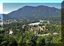
49. At 8.28 km, we are passing through a picturesque meadow.

Meadow Hiking in Manning Provincial Park
50. Looking left at the 8.28 km mark.

View from Skyline I Trail in Manning Provincial Park
51. The meadow continues at 8.43 km.

Skyline I Hike in Manning Provincial Park
52. Another fine view on the left side at 8.48 km.

Manning Provincial Park
53. At 8.51 km, the meadow is coming to an end.

Hike in Canada - Skyline I Trail in British Columbia
54. And, at the 8.77 km mark of Skyline I Trail, we are back in the forest.

Hiking in Manning Provincial Park British Columbia Canada
55. By the 9.00 km mark, we are getting out of the woods.

British Columbia Hiking
56. The trail makes a 90 degree turn here. Coordinates: N 49⁰02.331' W 120⁰55.130'. Elevation: 1,827 meters. We came from the right, and going to the left.

Hike in British Columbia
57-60. And right at this 90 degree turn there is a viewpoint with very fine views. Left-Right, zoomed, and panorama.


Manning Provincial Park
61-62. Just a bit further, there is a short ridge, and at the end of it the views are even better. But beware of a steep dropoff!


Hiking in British Columbia - Manning Provincial Park - Skyline I Trail
Here is our video of the views from this location.
More ihikebc videos are on our YouTube Channel.
63. A few hundred meters from the 90 degree trail turn, there is a split, where Skyline II Trail continues straight ahead (towards Mowich Camp, Hozomeen Ridge, and Skagit Road trailhead), and you can either take a right turn to complete a Skyline I loop trail via Strawberry Flats, or turn around, which is what we did.

Manning Provincial Park - British Columbia - Canada
Skyline I Trail is rather challenging, but offers very fine views. Highly recommended.


|
 |
Other Trips in Hope BC Area:
|
|
|
|
|
|
|
|
|
|
|
|
|
|
|
|
|
|
|
 |
|
|
|
|
|
Eaton Peak
Route
|
Skyline II West Trail
|
Eaton Lake
Hike 2
|
|
|


Other Trips:


![]()
![]()
![]()
ihikebc.com Trip 317 - Skyline I Trail Hike
(Manning Provincial Park near Hope, BC) Page 2 of 2