![]()
![]()
![]()

Trip 288 - August 1, 2023 (Tuesday)
Needle Peak Trail Hike
Off BC Highway 5 (Coquihalla) near Hope, BC
Page 2 of 2
Liked: Mountain views, shade in the forest, very few bugs.
Of Note: High altitude trail, the trail is popular, traffic noise from Highway 5 for much of the trail, little shade past the forest, uneven ground, rocks and roots, several steep sections – hiking poles and boots are highly recommended. Getting to the top of Needle Peak requires scrambling and is for experienced hikers only.
Vancouver, Coast & Mountains Backroad Mapbook (2019 edition) Trailhead Coordinates: Page 16 (Coquihalla Summit) D2.
A hike across the highway: Yak Peak Trail.
Another good hike nearby: Zoa Peak Trail.
Other Trips in Hope BC Area: Thacker Mountain Trail, Flat Iron Peak Trail, Sowerby Creek FSR Hike, Dog Mountain Trail, Jones Lake FSR Trip to Jones Lake, HBC Heritage Trail, Sowaqua Creek FSR, Skagit River Trail, Skyline II Trail Hike, Silver Skagit Road, Mount Outram Trail, Othello Tunnels, Eaton Lake Trail, Mount Hope Lookout Trail, Town of Hope BC
Follow @ihikebc TweetNeedle Peak Trail is found off BC Highway 5 (Coquihalla) North of Hope, and is pretty much right across a very prominent Yak Peak. Needle Peak is a bit easier to hike, despite having long steep stretches, and has very good views to match those of Yak Peak hike. Better yet, Needle Peak Trail leads to Flat Iron Trail, covered in the next trip report, which has some fine views of its own.
As for the peak itself, it is possible to hike just under the half of the 1 km distance to the end of the trail (route, actually, at this point) from where the junction of Needle Peak and Flat Iron trails is located 3.33 km from the trailhead, before it gets so steep that some non-technical climbing is required to proceed further. Keeping the Teetering Rock debacle in mind, we stopped right there and proceeded to hike Flat Iron Trail.
* All hiking distances are based on a GPS odometer and are approximate.
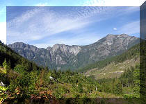
28. At 2.56 km we see Needle Peak ahead and to the left.

View from Needle Peak Trail near Hope BC Canada
29. Needle Peak Trail 300 meters later.

Needle Peak Trail
30. Walking on exposed stone at 2.75 km of the trail.

Hiking Needle Peak Trail
31-32. This is a fine point for the views behind us. Here is Yak Peak. Plain and zoomed.

Yak Peak view from Needle Peak

Yak Peak
33. Just a bit further.

View from Needle Peak Trail off Coquihalla Highway
34. Now at 2.82 km mark of Needle Peak Trail.

Hiking Needle Peak Trail
35. Looking right we see Flat Iron Peak, which we hiked later in the day.

Flat Iron Peak view from Needle Peak Trail
36-39. Another good time to turn back and take a look is at the 2.90 km mark. Coordinates: N 49⁰34.490' W 121⁰08.181'. Elevation: 1,740 meters. Left to right followed by a panorama.

Hiking in Hope BC Area

Hike in Canada

British Columbia Hiking

Needle Peak Trail Panorama
Here is our video of the views from this location:
More ihikebc videos are on our YouTube Channel.
40. Now at 3.15 km of the trail.

Needle Peak Trail near Hope British Columbia Canada
41. The mini-valley opens up at the 3.25 km mark.

Needle Peak Hike British Columbia
42-44. Finally, 3.33 km from the start, we are at a split, where Needle Peak proceeds to the left for one more kilometer, and 1.5 km-long Flat Iron Trail starts on the right side. Coordinates: N 49⁰34.205' W 121⁰08.240'. Elevation: 1,820 meters.


Needle Peak Trail Split with Flat Iron Peak Trail
45. We proceeded to the Needle Peak. At 50 meters from the split here.

Hiking in British Columbia Canada
46. At 120 meters.

Needle Peak
47. At 190 meters, things are about to get complicated.

Needle Peak British Columbia
48. Basically, it is possible to hike for 450 meters from the split, and then you need to climb for a bit. Does not appear overly difficult, if you are willing to do some non-technical climbing, but we took a pass.

Needle Peak
49. Flat Iron looks quite fine from here.

Flat Iron Peak view from Needle Peak
50. We looked around for an easier way to go up, but found none. So, that was the end of our Needle Peak hike.

Needle Peak Mountain British Columbia Canada
51-52. And here is a view of Needle Peak from Yak Peak. 2019 photos. Plain and zoomed.

Needle Peak View from Yak Peak

Needle Peak Trail has some challenging steep sections, but leads to very fine views. Highly recommended.


|
 |
Other Trips in Hope BC Area:
|
|
|
|
|
|
|
|
|
|
|
|
|
|
|
|
|
|
|
|
|
|
|
|
|
Eaton
Peak Route
|
Skyline II West Trail
|
Eaton
Lake Hike 2
|
|
|


Other Trips:


![]()


![]()
![]()
![]()
ihikebc.com Trip 288 - Needle Peak Trail Hike (Off BC Highway 5 near Hope, BC) Page 2 of 2