![]()
![]()
![]()

Trip 303 - October 5, 2023 (Thursday).
Lucky 4 Mine Trail Hike
Near Hope BC
Page 2 of 2
Liked:
Jones Lake views, mountain views, shade in the forest, colourful sub-alpine plants, (almost) no bugs.Of Note: No signs at all for this trail, the last 2 km of the trailhead access road is for 4x4 high clearance short wheelbase vehicles only, no shade in the alpine and sub-alpine, a very brushed-in section for over 1 km – rain paints / rain coat / waterproof boots are highly recommended, moderately difficult trail, slippery sections, some muddy spots, a few small creek crossing (some wading could be required early in the season or after a heavy rainfall), rocks and roots, hiking poles and boots are highly recommended.
Vancouver, Coast & Mountains Backroad Mapbook (2019 edition) Trailhead Coordinates: Page 5 (Chilliwack Lake) C3.Lucky 4 Mine Trail starts off a Jones Lake FSR 12.5 km split spur road (2.6 km-long), and continues for about 7.4 km to a good viewpoint of surrounding mountains. Fine Jones Lake views are also there. Foley Glacier, which can be seen from Jones Lake, is located near the end of the hike. Apparently, there used to be a mine near the glacier, hence the trail name. However, from what we could gather online, the mine entrance is quite hard to find, and to get there requires traversing very challenging terrain, so it's better left to those who know what they are doing.
The trail appears to be rarely traveled, and there are no signs at all pointing to the trail or indicating the trail start. There is a very overgrown stretch (hundreds of meters) around the middle of the trail, which is bound to thoroughly soak you, unless you have rain gear and waterproof boots. One the plus side, the views are quite good once you get to sub-alpine, and the bugs are (almost) not there.
*All trail distances are based on a GPS odometer and are approximate.
29. Mountain view at 6.0 km of Lucky 4 Mine Trail near Hope, BC.

Lucky 4 Mine Trail near Hope BC - mountains view
30. The trail itself at the same spot. It never gets too steep, though sun protection is needed in sub-alpine and alpine.

Hiking Lucky 4 Mine Trail in British Columbia Canada
31. The sub-alpine features fine mountain plants.

British Columbia sub-alpine plants
32-33. An interesting tree ahead. Plain and zoomed.


Hiking in British Columbia Canada
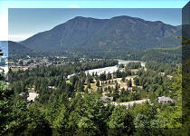
34. Looking back at Jones Lake at 6.03 km of the trail.

Jones Lake view from Lucky 4 Mine Trail near Hope BC
35-36. At 6.10 km, the tree is getting closer. Plain and zoomed.


Hike in Canada
37. Hike a bit more...

Lucky 4 Mine Trail near Hope BC
38...and Mile High camp is right there. So called because the elevation here is about a mile. Coordinates: N 49⁰10.524’ W 121⁰34.498’. Elevation: 1,630 meters.

Lucky 4 Mine Trail Mile High Camp
39. A fine view from the camp.

Jones Lake view from Mile High camp on Lucky 4 Mine Trail
40. And a sign by German Hiking Group, commemorating Werner Weis, whose life ended on this mountain in September of 1998 due to an accident. Rest in peace, Werner.

Werner Weis memorial sign
41. Continuing on Lucky 4 Mine Trail. At 6.56 km now.

Hope BC area hiking Lucky 4 Mine Trail
42. A fine view at 6.63 km.

British Columbia hiking
43. To the right is Foley Glacier (further right, out of frame).

Mountains of British Columbia
44. Looking back at the 6.84 km mark.

View from Lucky 4 Mine Trail
45. Lucky 4 Mine Trail at 6.92 km.

Hiking Lucky 4 Mine Trail in British Columbia Canada
46. At 7.10 km, we are in the alpine.

Alpine area of Lucky 4 Mine Hike near Hope BC
47. Now at the 7.21 km mark of Lucky 4 Mine Trail.

Hiking in Canada
48. At 7.40 km, we reached what might as well be the end of the trail. Coordinates: N 49⁰10.333’ W 121⁰34.111’. Elevation: 1,880 meters (1,135 meters elevation gain from the start of the trail. Average grade: 15%). It's a small flat area with neat shade to take a rest and have a break in an (almost) bug-free environment.

Lucky 4 Mine Hike
49. Looking back.

Hike in British Columbia
50. And straight ahead opens up an impressive mountain view.

Mountains of British Columbia
51-52. Zooming in.


British Columbia nature
53. Now a panorama.

BC mountains panorama
Here is our video of
the views from this location.
More ihikebc videos are on our YouTube Channel.
While it is possible to continue to Foley Glacier and look for the remnants of Lucky 4 Mine, the terrain is very challenging and better be left to people with knowledge and equipment to do it safely. Lucky 4 Mine Trail has many impressive views to make it a worthwhile outing. Highly recommended.


|
 |
Other Trips in Hope BC Area:
|
|
|
|
|
|
|
|
|
|
|
|
|
|
|
|
|
|
|
 |
|
|
|
|
|
Eaton
Peak Route
|
Skyline II West Trail
|
Eaton
Lake Hike 2
|
|
|


Other Trips:


![]()
![]()
![]()
ihikebc.com Trip 303 - Lucky 4 Mine Trail Hike (near Hope, BC)
Page 2 of 2