![]()
![]()
![]()

Trip 290 - August 2, 2023 (Wednesday)
Thacker Mountain Trail Hike
Hope, BC
Page 2 of 2
Liked: Fine views of Hope, Fraser River and mountains from all three viewpoints, shade in the forest, no bugs, fairly easy and relatively short loop trail.
Of Note: Steep unbarricaded drop-offs at all three viewpoints, remote urban noise all trail long, windy at the main viewpoint, no trail signs despite many intersecting trails, large nails sticking out from trees at face level at the 3rd viewpoint.
Vancouver, Coast & Mountains Backroad Mapbook (2019 edition) Trailhead Coordinates: Page 15 (Hope) F6.
Other Trips in Hope BC Area: Flat Iron Peak Trail, Needle Peak Trail, Sowerby Creek FSR Hike, Dog Mountain Trail, Jones Lake FSR Trip to Jones Lake, Yak Peak Trail, HBC Heritage Trail, Sowaqua Creek FSR, Zoa Peak Trail, Skagit River Trail, Skyline II Trail Hike, Silver Skagit Road, Mount Outram Trail, Othello Tunnels, Eaton Lake Trail, Mount Hope Lookout Trail, Town of Hope BC
Follow @ihikebc TweetThacker Mountain Trail is located in the town of Hope and starts at the end of Thacker Mountain Road, with detached houses standing right next to the trailhead. There is not a single sign pointing you in the direction of the trail, and not a single trail sign by the trailhead or along the trail, despite numerous intersecting paths. That said, it is a loop trail leading to three fine viewpoints, so just keep turning right, and that's all you need to get this hike done.
The first viewpoint arrives just 400 meters from the trailhead, so this could be the end of a very short hike, if all you want is a good view of Hope from above with an impressive Dog Mountain in the background. It takes another 900 meters to reach the second viewpoint next to a communication tower, and then 1.8 more kilometers to reach the third (main) viewpoint with the best views (though not by much). This last viewpoint features four large nails sticking out of the trees about 6 feet (1.8 m) from the ground, so watch out! Also, all three viewpoints have steep unbarricaded drop-offs, so watch your step.
After the third viewpoint, 1.4 km of hiking brings you back to the trailhead, for a total distance of under 5 km of (mostly) easy to moderately difficult hiking with a few short steep stretches.
Considering the maximum elevation of 240 meters, Thacker Mountain Trail makes an excellent 3+ season hiking destination.
* All hiking distances are based on a GPS odometer and are approximate.
33-34. Moving on towards the other two viewpoints, at 480 meters of Thacker Mountain Trail there is a large board with exclusion of liability information. Probably more for mountain bikers, than hikers, though all three viewpoints feature steep unbarricaded drop-offs, so watch your step.


34. Thirty meters later, there is a split. Coordinates: N 49⁰23.307' W 121⁰25.467'. Elevation: 180 meters. Going to the right leads to the second viewpoint in 1.3 km, and then there is another 1.82 km to the third (main) viewpoint. And going left here would lead to the third (main) and, arguably, the best viewpoint (if not by much) in about 850 meters.

Thacker Mountain Hiking British Columbia Canada
35. We turned to the right, and here is what Thacker Mountain Trail looks like 865 meters from the trailhead.

Hiking in Hope BC on Thacker Mountain
36. Another split at 1.10 km. Another right turn.

Thacker Mountain Trail
37. Getting close to the second viewpoint. A communication tower is standing nearby.

Communication tower on Thacker Mountain in Hope BC
38. Go around it on the left side.

Trail in Hope BC on Thacker Mountain
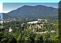
39-41. Arriving to the second Thacker Mountain viewpoint at the 1.3 km
mark. Coordinates:
N 49⁰23.226'
W 121⁰25.249'.
Elevation: 225 meters.
Left to right. That's Dog Mountain in the background.


Hope BC

42. Zooming in.

Aerial View of Hope British Columbia
43. Another look at the communication tower.

Thacker Mountain Communication Tower
Here is Our Video of the Views From The Second Thacker Mountain Viewpoint:
44-45. Heading towards the third viewpoint. Same split as in photo #36, but now on the way back from the second viewpoint. Turn right. We started counting distance again from this split.


46. At 25 meters from the split.

Thacker Mountain Hike
47. Now at 220 meters. Nice, easy hiking.

Hike on Thacker Mountain in Hope British Columbia Canada
48. At 270 meters, there is another split. The path on the right is actually a parallel path which rejoins the main path in a few hundred meters after passing by an overgrown viewpoint. Safe to ignore and keep going straight (left).

49. Thacker Mountain Hike at 920 meters from the split by the second viewpoint.

Hiking on Thacker Mountain
50. At 1.28 km, yet one more split. Coordinates: N 49⁰23.478' W 121⁰25.061'. Elevation: 200 meters. Right again.

Thacker Mountain
51. At 1.69 km, one last right turn before the third viewpoint.

52. At 1.79 km, we are almost there.

Thacker Mountain Trail British Columbia
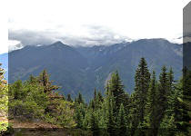
53. And here it is, the third (main) viewpoint of Thacker Mountain Trail. Coordinates: N 49⁰23.637' W 121⁰25.331'. Elevation: 240 meters. Windy, steep unbarricaded drop-offs, large nails sticking out of the trees about 6 feet (1.8 m) from the ground.

View from Thacker Mountain
54. Here is one of the nails.

55. Quite a view from here.

Hope BC
56-60. Now left to right, followed by a panorama.


61. With some zoom.

Hope British Columbia Canada
Here is Our Video of the Views From The Third Thacker Mountain Viewpoint:
More ihikebc videos are on our YouTube Channel.
Then, retrace your steps and turn right at the split seen in photo #51. Then, make a few more right turns and return to the trailhead about 1.4 km from the third viewpoint, for a total hiking distance of slightly under five kilometers. Thacker Mountain Trail is mostly easy, is quite pleasant, available in at least 3 seasons, and features very fine views. Highly recommended.


|
 |
Other Trips in Hope BC Area:
|
|
|
|
|
|
|
|
|
|
|
|
|
|
|
|
|
|
|
|
|
|
|
|
|
Eaton
Peak Route
|
Skyline II West Trail
|
Eaton
Lake Hike 2
|
|
|


Other Trips:


![]()


![]()
![]()
![]()
ihikebc.com Trip 290 - Thacker Mountain Trail Hike (Hope, BC) Page 2 of 2