![]()
![]()
![]()

Trip 093 - August 1, 2015 (Saturday)
Nesbitt's Knee Falls Trail Hike
Near Tumbler Ridge BC
Location: Northeastern British Columbia, approximately 65 kilometers Southeast of Tumbler Ridge.
Liked: Fairly easy trail, beautiful waterfall, very few flies.
Of note: Unbarricaded drop-offs, steep (though short) trail to the bottom of the falls (should you choose to go there).
Northern BC Backroad Mapbook (3rd edition) Coordinates: Page 44 (Tumbler Ridge) C4.
Other Trips off Murray River FSR: Barbour Falls, Stone Corral Trail Hike, Monkman Falls, Kinuseo Falls.
>>> British Columbia Waterfalls Visits.
Nesbitt's Knee Falls is a very fine small waterfall, which would make a great side trip en route to Kinuseo Falls, or would make a good destination by itself. For directions on getting to the Nesbitt's Knee Falls trailhead, which is located off Murray River Forest Service Road in the vicinity of Tumbler Ridge, check out our Kinuseo Falls and Barbour Falls trip reports.
1. We start at the split on Barbour Creek Road. This is the same photo as photo #4 of the Barbour Falls trip report. Going right at the split would lead to Barbour Falls trailhead. Going left would lead to Nesbitt's Knee Falls trailhead in 3.7 kilometers.

Barbour Creek Road British Columbia Canada
2. We took the road on the left, and, 3.7 kilometers later, arrived to Nesbitt's Knee Falls trailhead.

Nesbitt's Knee Falls Trailhead
3. The path to the falls viewpoint is short and, aside from the initial climb pictured below, very easy.

Tumbler Ridge Hiking -
Nesbitt's Knee Falls Trail BC Canada
4. After that short climb, it's like a walk in a park.

Hike in Tumbler Ridge area -
Nesbitt's Knee Falls Trail British Columbia
5. Ten minutes after the start of the hike, Nesbitt's Knee Falls appears in the distance.

Nesbitt's Knee Falls BC Canada
6. Zooming in.

Nesbitt's Knee Falls British Columbia
7. An information sign shows the falls in the winter.

Photo of Nesbitt's Knee Falls in Winter
8. If you do not feel like descending down a steep path to the bottom of the waterfall, this could be a final destination of a very short hike. But, if you are equipped to tackle the terrain, getting to the bottom of Nesbitt's Knee Falls is a great experience. Here is a split where going left would lead to the top of the falls and the canyon view, and going right would get you to the bottom of the waterfall.

Path to the Bottom of Nesbitt's Knee Falls
9. The ropes are there for assistance.

Rope on the path to the bottom of Nesbitt's Knee Falls
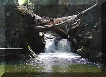
10. Your reward.

Nesbitt's Knee Falls View From the Bottom
Here is Our Video of Nesbitt's Knee Falls:
11. Nesbitt's Knee Falls looks great from the side too.

Nesbitt's Knee Falls British Columbia Canada
12. One of the best small waterfalls we have seen.

Nesbitt's Knee Falls BC Canada
Here is Our Video of the Side View of Nesbitt's Knee Falls:
More ihikebc videos are on our YouTube Channel.
13. We then returned to the split seen in photo #8, and are now taking the path on the left to the top of the waterfall. Follow the signs with arrows, as the path briefly leaves the woods onto an old forest service road, before re-entering the woods within a hundred feet.

Path to the top of Nesbitt's Knee Falls - Hike in Tumbler Ridge Area
14. Takes about five minutes to get there. First, the creek, which, in a few brief seconds, becomes a waterfall.

Creek forming Nesbitt's Knee Falls
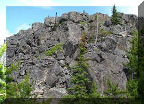
15. Now, the observation point. It's a dangerous area. Photos 16 and 17 were taken as we were laying on the stomach on the stone (shown in the photo below) and stretched the arm with the camera as far forward as we could. There are huge drop-offs to the left and to the right of this stone, and it is tilted towards the canyon below, so watch out.

16. The canyon.

17. The waterfall.

Nesbitt's Knee Falls
18. While going back towards the split, found a good view of the falls which does not require any stomach crawling. There is a less obvious path by the forest service road which does not require walking on the road itself, and from that less obvious path you can see the view in the photo below.

Photo of Nesbitt's Knee Falls BC Canada
19. Another information sign shows how much this waterfall gets transformed after a flood.

While not one of the tallest or one of the more powerful waterfalls in British Columbia, Nesbitt's Knee Falls is sure one of the most beautiful and easily accessible, and, as such, comes highly recommended.


|
 |
Other Trips in Tumbler Ridge BC Area:
|
|
|
|
|
|
|
|
|
|
|
|
|
|
|
|
|
Monkman
Falls Hike
|
|
Windfall Lake Trail  |
|
Cowmoose Mtn Trail
|
|
Bootski Lake Trail  |
|
Murray Canyon
Overlook
|
|
Quality Canyon Trail  |


Other Trips:


![]()


![]()
![]()
![]()
ihikebc.com Trip 093 - Nesbitt's Knee Falls Trail Hike (near Tumbler Ridge BC)