![]()
![]()
![]()

Trip 089 - July 4, 2015 (Saturday)
Babcock Falls Visit
Near Tumbler Ridge BC
Location: Northeastern British Columbia, about 35 kilometers Southeast of Tumbler Ridge.
Liked: The waterfall, the ability to get to the bottom of the falls, easy path, good access road.
Of note: No cell phone signal, mosquitoes, there is a need to cross an industrial road, the path to the bottom of the waterfall is treacherous.
Northern BC Backroad Mapbook (3rd edition) Coordinates: Page 44 (Tumbler Ridge) D5.
>>> British Columbia Waterfalls Visits.
Follow @ihikebc Tweet
Babcock Falls is a pleasant small waterfall off Core Lodge Road. It's easy to get to the trailhead, and the hike itself takes about 20 minutes. Other than the mosquitoes and an occasional damp spot, there were no issues. However, if you would choose to get from the main observation area to the bottom of the waterfall, you would definitely need hiking boots and poles, despite the entire trip to the bottom taking all of five minutes - it's VERY slippery down there.
1. Check out Boulder Gardens trip report to see how to get to Babcock Falls. The photo below is at the same spot as pictured in photo #8 of Boulder Gardens trip report. Going right at this spot would lead to Boulder Gardens and Shipyard & Titanic trails, while turning left would lead to Babcock Falls.

2. We turned left, and drove on a very good gravel road for about 600 meters.

The Road to Babcock Falls near Tumbler Ridge British Columbia Canada
3. The parking area and the trailhead would be on the left side. Coordinates: N 54⁰54.515' W 120⁰58.601'. Elevation: 1,345 meters. Driving just a bit further would lead to a cabin and a pit toilet.

Babcock Falls Parking Area
4. Shortly after the beginning of Babcock Falls Trail.

Tumbler Ridge Hiking -
Babcock Falls Trail British Columbia Canada
5. A sign requests to be careful, in case there is traffic on the road you are about to cross.

Babcock Falls Trail Industrial Traffic Warning
6. There are several boardwalks on Babcock Falls Trail.

Hike in Tumbler Ridge Area -
Babcock Falls Trail Boardwalk
7. Kudos to volunteers who installed these boardwalks.

Babcock Falls Trail Volunteers
8. The path is quite easy, with very little elevation change.

Photo of Babcock Falls Trail - Hiking in British Columbia Canada
9. In just over twenty minutes, we are there. Several information placards show interesting facts about Babcock Falls.

Babcock Falls Area in the Winter
10. Babcock Falls from the main observation area. Coordinates: N 54⁰54.489' W 120⁰57.718'. Elevation: 1,306 meters.

Babcock Falls British Columbia Canada
11. Now with a bit of a zoom.

Babcock Falls by Tumbler Ridge BC Canada
Here is our video of Babcock Falls from the observation area:
12. If you are feeling adventurous and are properly equipped, why not check out the bottom of the waterfall.

Babcock Falls End of Trail Sign
13. The path is steep, but short.

Path to the Bottom of Babcock Falls
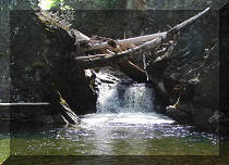
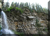
14. In the middle of the path to the bottom of the waterfall, you get what could be the best view of Babcock Falls.

Babcock Falls British Columbia Canada
15. At the very slippery bottom, the view is not nearly as good.

View From The Bottom of Babcock Falls
16. Looking left.

Babcock Falls BC Canada
17. Lots of water.

Babcock Falls
Here is our video of Babcock Falls from the bottom:
More ihikebc videos are on our YouTube Channel.
While hardly a destination by itself, Babcock Falls could be a good side trip when you come to hike Boulder Gardens, Shipyard & Titanic, or other nearby trails.


|
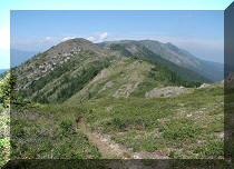 |
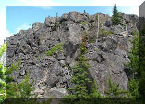
Other Trips in Tumbler Ridge BC Area:
|
|
|
|
|
|
|
|
|
|
|
|
|
|
|
|
|
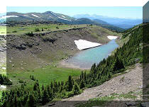
Monkman
Falls Hike
|
|
Windfall Lake Trail  |
|
Cowmoose Mtn Trail
|
|
Bootski Lake Trail  |
|
Murray Canyon
Overlook
|
|
Quality Canyon Trail  |


Other Trips:


![]()


![]()
![]()
![]()
Follow @ihikebc Tweet
ihikebc.com Trip 089 - Babcock Falls Visit (near Tumbler Ridge BC)