![]()
![]()
![]()

Trip 092 - August 1, 2015 (Saturday)
Barbour Falls Trail Hike
Near Tumbler Ridge BC
Location: Northeastern British Columbia, approximately 63 kilometers Southeast of Tumbler Ridge.
Liked: Easy trail, the waterfall, very few flies.
Of note: Unbarricaded drop-offs, jagged stones at the bottom of the creek pool (should you choose to go swimming).
Northern BC Backroad Mapbook (3rd edition) Coordinates: Page 44 (Tumbler Ridge) B5.
Other Trips off Murray River FSR: Nesbitt's Knee Falls, Stone Corral Trail Hike, Monkman Falls Hike, Kinuseo Falls.
>>> British Columbia Waterfalls Visits.
Follow @ihikebc Tweet
Barbour Falls is located near Tumbler Ridge, off Murray River Forest Service Road, which, eventually, leads to much more impressive Kinuseo Falls. However, Barbour Falls is a decent waterfall in its own right, and, along with nearby Nesbitt's Knee Falls, could serve as a good side trip for Kinuseo Falls-bound folks. Check out our Kinuseo Falls Trip Report for directions on how to get to Murray River FSR.
1. We are at the 21.4 km mark of the Murray River Forest Service Road, getting ready to turn left. Coordinates: N 54⁰56.981' W 121⁰09.386'. Going straight at this juncture would eventually lead to Monkman Provincial Park and Kinuseo Falls, as well as Monkman Falls Trail.

Murray River FSR At Barbour Creek Road by Tumbler Ridge British Columbia
Canada
2. Soon after turning onto what now is Barbour Creek Road, there is a bridge across Murray River.

Barbour Creek Road Bridge Across Murray River
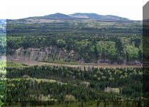
3. View of Murray River from the bridge.

Murray River BC Canada
4. One kilometer after turning left from Murray River FSR, there is a split on Barbour Creek Road. Going right leads to Barbour Falls, and going left to Nesbitt's Knee Falls. We took the road on the right.

Barbour Creek Road near Tumbler Ridge BC Canada
5. Barbour Falls Trail parking area and trailhead would be on the left side, 2.4 km after the split (and 3.4 km after the turn from Murray River FSR). Here we are already at the parking area. Coordinates: N 54⁰55.937' W 121⁰08.290'. The road we took to get here can be seen on the left side.

Parking Area for Barbour Falls Hiking Trail British Columbia Canada
6. The trail to the waterfall is less than a kilometer long, and is as easy as they get.

Barbour Falls Trail - Tumbler Ridge Hiking British Columbia Canada
7. Shortly before the viewpoint, there is a split. The waterfall path is to the right. And, to the left, is a steep descent to Barbour Creek and pool.

Hiking in Tumbler Ridge Area -
Barbour Falls Trail Split With Barbour Creek Trail
8. At first, we took the path to the right towards the waterfall.

Tumbler Ridge Hike -
Photo of Barbour Falls Trail British Columbia Canada
9. Beware of the drop-offs.

Barbour Falls Drop-Offs Warning
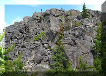
10. Here is the canyon.

Barbour Falls Canyon
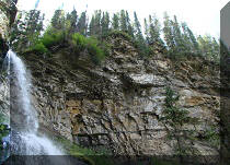
11. And here is the waterfall.

Barbour Falls By Tumbler Ridge BC Canada
12. Barbour Falls with a slight zoom.

Barbour Falls British Columbia Canada
Here is our video of Barbour Falls:
More ihikebc videos are on our YouTube Channel.
13. We are heading back towards the split seen in photo #7.

Barbour Falls Trail - Hike British Columbia
14. Back at the split.

Sign to Barbour Creek and Pool
15. A caution sign. Also, note the rope. The path is quite steep at this point, so you may want to bring your hiking poles.

Barbour Creek Warning Sign
16. Another warning for would-be swimmers.

Barbour Creek Pool Warning Sign
17. After a few minutes, here is Barbour Creek, with a mini-waterfall to boot.

Barbour Creek British Columbia Canada
18. Zooming in.

Barbour Creek Mini-Waterfall
19. The pool with jagged rocks.

Barbour Creek Pool
20. Looking to the right, we see more of Barbour Creek, as it flows en route to Barbour Falls.

Barbour Creek by Tumbler Ridge BC Canada
21. An information sign shows what Barbour Falls looks like when there is more water in the creek.

Barbour Falls Information Sign
While hardly a destination on its own, Barbour Falls is a good side trip as a part of the visit to Kinuseo Falls and/or Nesbitt's Knee Falls.


|
 |
Other Trips in Tumbler Ridge BC Area:
|
|
|
|
|
|
|
|
|
|
|
|
|
|
|
|
|
Monkman
Falls Hike
|
|
Windfall Lake Trail  |
|
Cowmoose Mtn Trail
|
|
Bootski Lake Trail  |
|
Murray Canyon
Overlook
|
|
Quality Canyon Trail  |


Other Trips:


![]()


![]()
![]()
![]()
Follow @ihikebc Tweet
ihikebc.com Trip 092 - Barbour Falls Trail Hike (near Tumbler Ridge BC)