![]()
![]()
![]()

Trip 087 - July 2, 2015 (Thursday)
Boulder Gardens Route Hike
Near Tumbler Ridge BC
Page 1 of 2
Location: Northeastern British Columbia, about 40 kilometers
Southeast of Tumbler Ridge.
Liked: View of boulders, the route is a circuit, the route is well-marked and is fairly easy, strong wind kept most mosquitoes away, easy access via Highway 52 and industrial roads.
Of note: No cell phone signal, numerous dangerous crevices and steep drop-offs, hiking boots and poles are highly recommended.
Northern BC Backroad Mapbook (3rd edition) Coordinates: Page 44 (Tumbler Ridge) D5.
Follow @ihikebc Tweet
Boulder Gardens Route (not to be confused with Boulder Canyon Trail near Muncho Lake) is a unique hike, as you get to see numerous haphazard rock formations, some of which are simply fantastic. The route is easy-to-moderate, but, considering much rock-hopping is involved, it would be a good idea to hike Boulder Gardens only when the ground and, especially, the stones are completely dry. Also, due to frequent wind gusts, stay away from the edges of numerous steep drop-offs found along this route.
1. We are Southeast-bound on Highway 52, Southeast of Tumbler Ridge.

BC Highway 52 Southeast of Tumbler Ridge
2. Approximately 25 kilometers from Tumbler Ridge, a sign would indicate a right turn is required to get to Boulder Gardens, Babcock Falls, and Shipyard and Titanic trails (among others).

BC Highway 52 by Core Lodge Road
3. The turnoff to Core Lodge Road follows shortly. Coordinates: N 54⁰59.502' W 120⁰52.487'.

BC Highway 52 Turnoff to Core Lodge Road
4. In a photograph of a map located by Tumbler Ridge Visitor Centre, we have indicated the turnoff seen above with a red arrow, and Boulder Gardens trail with a yellow arrow.

Map of Tumbler Ridge Area
5. Core Lodge Road. Quite smooth. Speed limit 60 km/h. Watch for industrial traffic.

Core Lodge Road Near Tumbler Ridge British Columbia Canada
6. At the 5.7 km mark, make a left turn.

Core Lodge Road
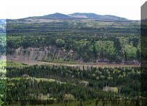
7. There are some good views along Core Lodge Road.

Core Lodge Road by Tumbler Ridge BC Canada
8. Make a right turn at the 12.9 km mark (going left there would lead to the mine). Then, take another road to the right at the 13.4 km mark, pictured below. This is the way to Boulder Gardens and Shipyard & Titanic trails. Taking the road on the left here would eventually lead to Babcock Falls - a blue sign on the right side of the photo below provided that information.

9. Roman Mountain seen on the left. This is where the mine is located.

Roman Mountain British Columbia Canada
10. At the 14.5 km mark, we have reached the parking area (seen on the left) for Boulder Gardens Route. On the right is the road we just drove on to get here. Behind us (i.e. going further up the mountain) is the continuation of the road - 2.2 km later would be the parking area for Shipyard & Titanic Trail.

Boulder Gardens Route Parking Area
11. View of the moon in the evening above Roman Mountain from the Boulder Gardens Route parking lot.

Roman Mountain in the Evening
12. The hike begins. Coordinates: N 54⁰54.827' W 120⁰58.588'.

Boulder Gardens Hiking Route Directions
13. Serious messages.

Boulder Gardens Route Warning Messages
14. Very shortly, there is a split. Straight ahead is Emperor's Challenge. It's some sort of a local mountain running event. Our hike is to the left.

15. The first good view arrives in no time.

View From Boulder Gardens Hiking Route BC Canada
16. Boulder Gardens is a circular route, so the signs direct you to do the circle.

BC Hiking -
Boulder Gardens Route Near Tumbler Ridge British Columbia Canada
17. The path then goes through some trees for a few minutes, until...

Tumbler Ridge Hiking -
Boulder Gardens Route BC Canada
18. ...we are directed to the first short side trip called "Rock Chimney".

Hike in Tumbler Ridge Area -
Boulder Gardens Route Sign to Rock Chimney
Our Boulder Gardens Route Hike Trip Report Continues on Page 2.


|
 |
Other Trips in Tumbler Ridge BC Area:
|
|
|
|
|
|
|
|
|
|
|
|
|
|
|
|
|
Monkman
Falls Hike
|
|
Windfall Lake Trail  |
|
Cowmoose Mtn Trail
|
|
Bootski Lake Trail  |
|
Murray Canyon
Overlook
|
|
Quality Canyon Trail  |


Other Trips:


![]()


![]()
![]()
![]()
Follow @ihikebc Tweet
ihikebc.com Trip 087 - Boulder Gardens Route Hike (near Tumbler Ridge BC) Page 1 of 2