![]()
![]()
![]()

Trip 290 - August 7, 2023 (Monday)
Williams Ridge Trail Hike
Near Chilliwack, BC
Page 2 of 2
Liked: Easy trailhead access off Chilliwack Lake Road, Chilliwack Lake view, Williams Peak view, the views of the surrounding mountains, meeting several pikas at the end of the trail, shade in the forest, almost no bugs.
Of Note: Some encroaching vegetation along the trail, the first half of the trail is very steep, uneven ground, rocks and roots, hiking poles and boots are essential.
Vancouver, Coast & Mountains Backroad Mapbook (2019 edition) Trailhead Coordinates: Page 5 (Chilliwack Lake) D5.
103 Hikes in Southwestern British Columbia (2008 edition): hike #72.
Other Trips in Chilliwack Area: Flora Lake Trail, Mount Thom Lookout Loop Trail, Vedder Rotary Loop Trail, Teapot Hill Trail Hike, Chilliwack Dyke Trail, Greendrop Lake Trail, Mount Cheam Peak Trail, Ling Lake Trail Hike (off Chilliwack Foley FSR), Chilliwack Foley FSR, Chilliwack Bench FSR, Elk-Thurston Trail, Slesse Memorial Trail, Downtown Chilliwack BC Visit, Chilliwack Lake FSR, Radium Lake Trail, Chilliwack Lake Provincial Park, Minter Gardens, Town of Agassiz BC, Bridal Veil Falls Provincial Park.
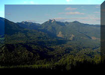
Follow @ihikebc TweetWilliams Ridge Trail is located off Chilliwack Lake Road not far from Chilliwack Lake Provincial Park. This trail is easy for the first 370 meters, but then rises steeply until about the 3 km mark, where there is a junction with a connecting trail to Ford Mountain on the left side, while Williams Ridge Trail (now much easier, though still with an occasional brief steep stretch) carries on for another 3.5 km on the right side, with mountain glimpses here and there, to a knoll with panoramic views of Williams Peak, Chilliwack Lake, and a whole bunch of surrounding mountains.
Thus, it is possible for the hikers with iron legs to do a Ford Mountain - Williams Ridge loop hike, especially if they have a second vehicle for a shuttle run. Ford Mountain Trail access road (4x4 only) is located 4 km closer to Chilliwack than Williams Ridge trailhead. That said, Williams Ridge is quite a challenge to hike up, but also down, with our knees protesting the downhill travel like on few other trails we have hiked, and Ford Mountain is unlikely to be much easier. Thus, iron legs are definitely in order for anyone contemplating to do both trails in one go.
Once you are on that fine knoll with pikas running around and all those good views, Williams Ridge Trail ends, and Williams Peak Route begins. Williams Peak is quite challenging, so plan for at least a 12 hour round trip hike from the Chilliwack Lake Road trailhead, if you want to tackle the peak as well.
* All hiking distances are based on a GPS odometer and are approximate.
31. Williams Ridge Trail at 4.61 km from the trailhead by Chilliwack Lake Road.

Williams Ridge Trail
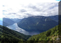
32-33. The next viewpoint arrives at 5.20 km, and this time we can see the North end (Chilliwack Lake Provincial Park end) of Chilliwack Lake. Plain and zoomed.


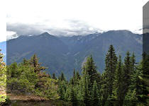
34. At 5.41 km of the hike.

Hiking Williams Ridge Trail
35-36. The next viewpoint is at 5.58 km of Williams Ridge Trail. Plain and zoomed.

Williams Ridge Trail View

37. At 5.65 km.

Chilliwack Hiking - Williams Ridge Trail
38-39. At the 5.91 km mark, we get the first view of Williams Peak. Plain and zoomed.


Williams Peak near Chilliwack BC Canada
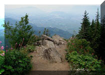
40. The last fine viewpoint is just 100 meters before the end of the trail. There are a bunch of interesting stones straight ahead...

Williams Ridge Hike near Chilliwack BC
41...and a neat view to the right.

View from Williams Ridge Trail near Chilliwack BC
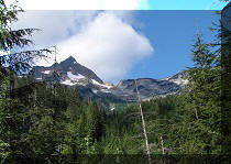
42. Just past the stones in photo #40, an awesome view of Williams Peak.

Williams Peak British Columbia Canada
43. With a zoom.

Williams Peak British Columbia
44-49. Also just past the stones there is a trail split. To the right is about 70 meters until a knoll with panoramic views of Williams Peak, Chilliwack Lake, and the surrounding mountains. To the left is an unknown trail, but, chances are, it is Williams Peak loop trail. We turned right, reached the knoll, and here are the views left-to-right, followed by a panorama. Coordinates: N 49⁰07.490' W 121⁰31.178'. Elevation: 1,620 meters.


Here is Our Video of the Views From This Location:
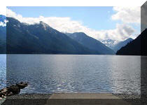
50-55. Here are zoomed views of the mountain peaks to the right of Chilliwack Lake.


56. Chilliwack Lake zoomed.

Chilliwack Lake
57. There were also several pikas running around that area.

Pika
Here is Our Video of the Pika (the same or another one):
More ihikebc videos are on our YouTube Channel.
58-59. Finally, if you decide to climb Williams Peak, you would need to descent first, and then start what looks like a very steep climb.

Chilliwack Lake view from Williams Ridge Peak

Williams Ridge Hike near Chilliwack BC Canada
Williams Ridge Trail is very steep at the beginning (and at the end, on the way back), but leads to impressive views. Recommended.


|
 |
Other Trips in Chilliwack BC Area:
|
|
|
|
|
|
|
|
|
|
|
|
|
|
|
|
|
Greendrop Lake Trail
|
|
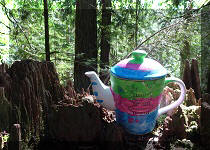
Teapot Hill Trail
|
|
Vedder Rotary Trail
|
|
Mount Thom Trail
|
|
Flora Lake Trail |


Other Trips:


![]()


![]()
![]()
![]()
ihikebc.com Trip 291 - Williams Ridge Trail Hike (Near Chilliwack, BC) Page 2 of 2