![]()
![]()
![]()

Trip 201 - April 16, 2021 (Friday)
Teapot Hill Trail Hike
Cultus Lake Provincial Park
Near Chilliwack BC
Distance from Vancouver to the Trailhead: 105 kilometers: 90.5 km from Vancouver via Highway 1 East (Grandview Hwy entrance to Hwy 1) to Exit 119 (Yale Rd / Vedder Rd) in Chilliwack. Then, 5.5 km on Vedder Road to Vedder Mountain Road. Then 0.7 km to Cultus Lake Road (which will eventually become Columbia Valley Road). Then 8.5 km to Teapot Hill trailhead.
Liked: Shade in the forest, moss on trees, various teapots by the trail, the view from the top, rather easy trail.
Of Note: Limited parking by the trailhead, the trail is popular, horse manure on the trail. A few short steep sections. Hiking poles and boots are recommended.
Vancouver, Coast & Mountains Backroad Mapbook (5th edition) Trailhead
Coordinates: Page 4 (Chilliwack)
C6.
Related Website:
Other Trips in Chilliwack Area: Flora Lake Trail, Williams Ridge Trail, Mount Thom Lookout Loop Trail, Vedder Rotary Loop Trail, Chilliwack Dyke Trail, Greendrop Lake Trail, Mount Cheam Peak Trail, Ling Lake Trail Hike (off Chilliwack Foley FSR), Chilliwack Foley FSR, Chilliwack Bench FSR, Elk-Thurston Trail, Slesse Memorial Trail, Downtown Chilliwack BC Visit, Chilliwack Lake FSR, Radium Lake Trail, Chilliwack Lake Provincial Park, Minter Gardens, Town of Agassiz BC, Bridal Veil Falls Provincial Park.
This particular Teapot Hill Trail is located just South of Chilliwack, in Cultus Lake Provincial Park, and is not to be confused with Teapot Mountain Trail North of Prince George. Both trails are similar in that they are quite short, popular, and feature numerous teapots by the side of the trail, left there by hikers to commemorate the occasion of visiting the trail. The view from Teapot Mountain is substantially better, but Teapot Hill also has a decent view from the top. Teapot Hill is also not nearly as steep, and had no mosquitoes at all during our hike, perhaps because it's still early in the season. That said, there are definitely many more mosquitoes up North than it is in the Lower Mainland, no matter which trail you hike. However, unlike its Northern cousin, Teapot Hill Trail has an occasional horse rider for much of the way, so watch out for manure while enjoying the nature.
This trail is 2.5 km long, and can be done in about an hour round-trip, at brisk pace. Dogs are allowed, but must be kept on a leash. Horses are allowed for the first 1.5 km, at which point riders may continue on Watt Creek Trail, while the last kilometer of Teapot Hill Trail is reserved for hikers only.
1-2. To get to Teapot Hill Trail from Vancouver, take Highway 1 East, and use Exit 119 to Vedder Road. Keep right after the exit.
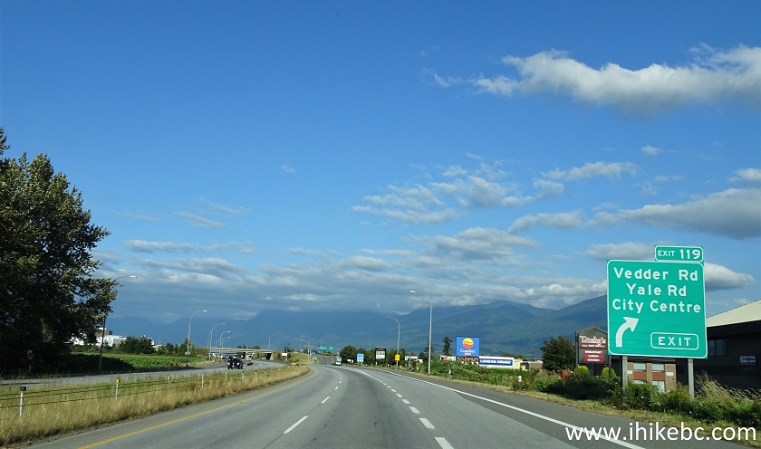
TransCanada Highway 1 Eastbound in Chilliwack BC Approaching Exit 119
Vedder Rd / Yale Rd - August 2020 photo
TransCanada Highway 1 East Exit 119 Vedder Road / Yale Road/ Chilliwack City
Center - August 2020 photo
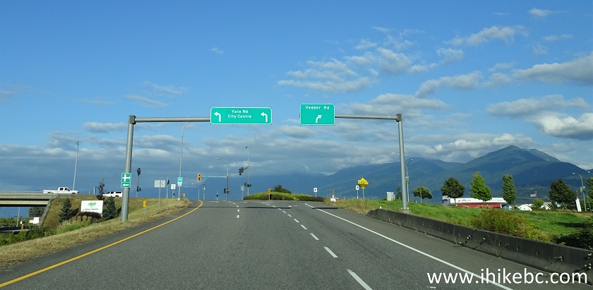
3. Having turned right, drive on Vedder Road for 5.5 km, and reach this roundabout.
Vedder Road Chilliwack BC Canada
4. Take the first exit to Vedder Mountain Road.

Vedder Road Roundabout - Exit to Vedder Mountain Road
5. Drive for 700 meters to another roundabout.

Vedder Mountain Road
6. Take the second exit to Cultus Lake Road.

Vedder Mountain Road Roundabout - Exit to Cultus Lake
Road
7. About 2 km later, stay left at this fork, as Cultus Lake Road becomes Columbia Valley Highway.

Cultus Lake Road becoming Columbia Valley Highway
8. Drive on Columbia Valley Highway to Cultus Lake Provincial Park.

Columbia Valley Highway near Chilliwack British
Columbia Canada
9-10. At 9.2 km, there is another roundabout. Take the second exit to Columbia Valley Highway East.


Columbia Valley Highway Roundabout
11. At 12.3 km, enter Cultus Lake Provincial Park.

Cultus Lake Provincial Park Entrance
12. A campground entrance and several day use areas follow shortly. You may need to park at one of the day use areas, as parking by the trailhead is limited to about 25-30 vehicles, including the parking lot and the side of the road. Here we are approaching Teapot Hill trailhead parking, seeing on the left side.

Columbia Valley Road by Teapot Hill Trailhead in
Cultus Lake Provincial Park
13. Arriving at Teapot Hill trailhead parking lot, 14.7 km after exiting Highway 1. Coordinates: N 49⁰02.555' W 121⁰59.025'. Elevation: 47 meters.

Teapot Hill Trailhead Parking Lot
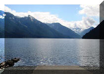
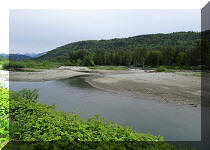
13. There is a Cultus Lake viewpoint closer to the end of the trail, but it's badly overgrown. Here is a neat view of the lake right by the parking lot.

Cultus Lake
14. Frustrate vacation-deprived thieves by hiding your valuables before starting the hike.

Teapot Hill Trailhead
15. Teapot Hill Trail is easy-to-moderately challenging. There is a very gentle elevation gain all the way to the top, with one or two rather steep, but short sections.

Teapot Hill Trail - Chilliwack Hike
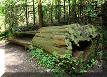
16. One of the most impressive features of Teapot Hill Trail is hanging moss on numerous trees.

Moss on Trees - Teapot Hill - Chilliwack Trail
17. A positive message for Teapot Hill hikers.

It Never Rains Forever message on a stone
18. Inspirational quote of the hike.

Go The Extra Mile - It's Never Crowded message on a
stone
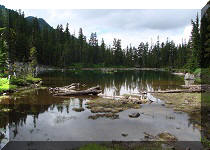
19. Teapot Hill trail intersects with other trails, so it's possible to hike in a loop. At 1 km mark, our trail continues straight ahead. To the left is the way to Edmeston Road trailhead (7.8 km).

Hike in Chilliwack Area - Teapot Hill Trail in Cultus
Lake Provincial Park
20. Teapot Hill Trail is quite popular, and there was no shortage of other hikers even on a weekday morning. On weekends, especially during the Summer, it's going to be crowded.

Teapot Hill Hike
21. At 1.5 km, the trail makes a right turn. Horses are not permitted beyond this point, and the riders may either return the same way, or proceed straight ahead on Watt Trail (2.3 km) or Horse Trail Loop (2.4 km).

Teapot Hill Trail in Chilliwack BC Area
22. We turned to the right.

Hiking in Chilliwack Area - Teapot Hill Trail
23. Shortly after the turn.

Teapot Hill Trail Cultus Lake Provincial Park British
Columbia Canada
24. There are two information stands on Teapot Hill trail. One of them describes how a lightning works. The other, pictured below, talks about some of the plants found in this area.

Plants of Teapot Hill Information Board
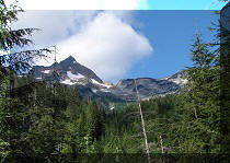
25. Getting close to the top.

Teapot Hill Hike
26-27. There are close to 70 teapots of all sizes and shapes located by the side of the trail, most of them after the 1.5 km turn. Here are some of the better ones we have found.


Teapot on Teapot Hill
28. A welcome feature of Teapot Hill Trail is the presence of shade virtually all trail long.

Teapot Hill Trail - Chilliwack Hiking
29. There is some minor traffic noise here and there, but, by and large, it's a very peaceful, easy hike.

Trail in Chilliwack Area - Teapot Hill
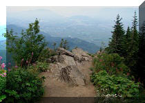
30. And we are at the top, after 2.5 km of hiking. It took 42 minutes to get here. Coordinates: N 49⁰01.814' W 121⁰59.804'. Elevation: 291 meters (244 meters elevation gain from the start of the trail).

Teapot Hill Observation Area
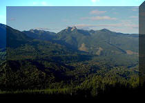
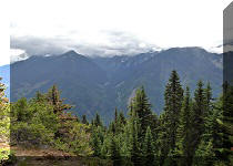
31. It's a rather large fenced-off area. However, most of the views are obstructed by trees, and only about a 10-meter stretch by the fence has an opening large enough to see Columbia Valley below.

Columbia Valley seen from Teapot Hill
Here is our video of from the top of Teapot Hill.
More ihikebc videos are on our YouTube Channel.
32. We returned to the parking lot in 26 minutes of fast hiking.

Teapot Hill Parking Lot
Teapot Hill trail is short, fairly easy, pleasant, and leads to a decent view. Recommended.


|
 |
Other Trips in Chilliwack BC Area:
|
|
|
|
|
|
|
|
|
|
|
|
|
|
|
|
|
Greendrop Lake Trail
|
|
|
|
Vedder Rotary Trail
|
|
Mount Thom Trail
|
|
Flora Lake Trail  |


Other Trips:


![]()
![]()
![]()
ihikebc.com Trip 201 - Teapot Hill Trail Hike (Near Chilliwack BC)