![]()
![]()
![]()

Trip 259 - June 17, 2022 (Friday)
Pender Hill Trail Hike
North of Sechelt BC
Near Madeira Park (BC Sunshine Coast)
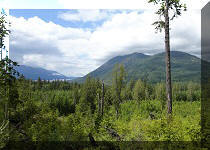
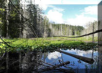
Liked: Panoramic views from the top of the mountain, several fine forest scenes, shade in the forest, no bugs.
Of Note: Steep unbarricaded drop-offs at the top of the mountain, industrial noise heard at the top of the mountain, moderately challenging trail with some short steep stretches, hiking poles and boots are highly recommended.
Vancouver, Coast & Mountains Backroad Mapbook (5th edition) Park Coordinates: Page 9 (Sechelt) A1.
Nearby Hike: Mount Daniel Trail (off Garden Bay Road).
Pender Hill is a small mountain in the unincorporated Madeira Park area of British Columbia's Sunshine Coast, approximately 47 kilometers North of Sechelt via BC Highway 101, (turn left onto) Garden Bay Road, (proceed straight onto) Irvines Landing Road, and (turn right onto) Lee Road. The trailhead is located by the corner of Lee Road and Coastview Drive, 9.5 km after turning from BC Highway 101 onto Garden Bay Road.
Pender Hill Trail is quite short (about 850 meters one way), and is moderately difficult with several short steep stretches. It leads to a very fine panoramic harbour and ocean viewpoint.
All trail distances are based on a GPS odometer and are approximate.
1. Here are Google Maps directions from Sechelt to Pender Hill Trailhead.
2. We are on BC Highway 101 North of Sechelt, 200 meters away from Garden Bay Road.

BC Highway 101 near Garden Bay Road - Sunshine Coast
North of Sechelt
3-4. Making a left turn from BC Highway 101 onto Garden Bay Road, just past Petro Canada gas station.

BC Highway 101 at Garden Bay Road North of Sechelt

BC Highway 101 at Garden Bay Road Madeira Park
British Columbia Canada
5. Garden Bay Road, 300 meters after turning from BC Highway 101.

Garden Bay Road - Madeira Park BC
6. At 5.5 km, Garden Bay Road goes left, but we need to drive straight onto Irvines Landing Road.

Garden Bay Road at Irvines Landing Road
7. At 8.5 km after turning from BC Highway 101, make a right turn from Irvines Landing Road onto Lee Road.

Irvines Landing Road at Lee Road
8. Lee Road after the turn.

Lee Road - Madeira Park - BC Sunshine Coast
9. At 9.5 km, Lee Road arrives to Coastview Drive (on the right), and the sign seen in the middle-right is showing that Pender Hill Park is right here.

Lee Road at Coastview Drive - Madeira Park BC
10. The sign up close. Proceed 50 meters to the parking lot.

Pender Hill Park - British Columbia Sunshine Coast
11. Pender Hill Park parking lot. Good for 5-6 vehicles. Coordinates: N 49°38.541’ W 124°03.699’. Elevation: 70 meters.

Pender Hill Park Parking Lot
12. The Pender Hill trailhead is right at the parking lot.

Pender Hill Trailhead
13. Pender Hill Trail 50 meters from the trailhead.

Pender Hill Trail - BC Sunshine Coast
14. A small boardwalk at 110 meters.

Sechelt Hiking - Pender Hill Trail
15. Now at 230 meters from the parking lot.

Pender Hill Trail Hike near Sechelt BC Canada
16. A funny "sad tree" with a "long nose" at 300 meters.

Funny Tree
17-18. Pender Hill Trail is moderately challenging, but a few stretches are quite steep, like this one, starting at 600 meters from the trailhead.

Pender Hill Trail

Pender Hill Trail near Sechelt British Columbia
19. At 780 meters, we are almost there, just go up this hill...

Pender Hill Hike BC Sunshine Coast
20. And here we are, 21 minutes after the trailhead (took us 16 minutes to get back). Coordinates: N 49°38.400’ W 124°03.327’. Elevation: 240 meters (170 meters elevation gain from the trailhead, for an average grade of about 20%).

Pender Hill near Sechelt BC
21. A bench next to an arbutus tree to chill before or after checking out the viewpoint.

Bench on Pender Hill - Hike in British Columbia
Canada
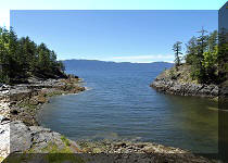
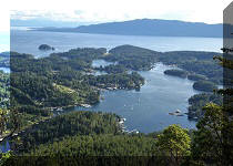
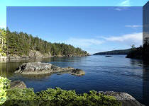
22-26. And the viewpoint is quite impressive indeed. Left to right, followed by a panorama. Hotel Lake is in photo #22, beyond it is Pender Harbour, and, to the right, is Lee Harbour.

Hotel Lake view from Pender Hill near Sechelt BC

Pender Harbour view from Pender Hill


Lee Harbour BC Sunshine Coast View from Pender Hill

Pender Hill Viewpoint Panorama
27. With much zoom, we see a small rock with a lighthouse - to the left is William Island.

Lighthouse by William Island BC Sunshine Coast
Here is our video of the views from this location.
More ihikebc videos are on our YouTube Channel.
Pender Hill Trail is a bit challenging, but is very short and leads to a great view. Highly recommended.


|
 |
Other Trips on BC Sunshine Coast:
|
|
|
|
|
|
|
|
|
|
|
Other Trips:


![]()
![]()
![]()
ihikebc.com Trip 259 - Pender Hill Trail Hike (BC Sunshine Coast North of Sechelt)