![]()
![]()
![]()

Trip 257 - June 16, 2022 (Thursday)
Smuggler Cove Trail Hike
Smuggler Cove Marine Provincial Park
Near Halfmoon Bay (BC Sunshine Coast)
Page 1 of 2
Liked: A short and easy trail to excellent cove/shoreline views and marsh/wetlands views. Shade in the forest. No bugs. An open air biology and zoology class with numerous information stands along the trail.
Of Note: Steep unbarricaded drop-offs at the main cove viewpoint. Uneven ground and slippery stones by the cove shore. Rocks and roots, a few moderately steep sections, hiking poles and boots are recommended.
Vancouver, Coast & Mountains Backroad Mapbook (5th edition) Trailhead Coordinates: Page 9 (Sechelt) C4.
Related Website: Smuggler Cove Marine Provincial Park - BC Parks Official Website.
An easy trail of 1.65 km long leads from Smuggler Cove Marine Provincial Park parking lot by Brooks Road off BC Highway 101 on Sunshine Coast (ferry from Horseshoe Bay gets you there from the Lower Mainland) to the beginning of a 700 meter-long loop around Smuggler Cove, with several excellent viewpoints. Even before you get to the loop, the trail goes by a very long and absolutely beautiful wetlands/marsh area, the largest and the most picturesque that we have ever seen in British Columbia.
In addition, there are about ten information stands along the trail describing local flora and fauna - everything from mosses and lichens to beavers and ducks. It's an open air biology and zoology lesson in a very beautiful setting.
All trail distances are based on a GPS odometer and are approximate.
1. Here is a Google map of Smuggler Cove Marine Provincial Park.
2. We are on BC Sunshine Coast, Northbound on Highway 101, North of Sechelt, with 150 meters to go before a left turn to Brooks Road.

BC Highway 101 North of Sechelt
3. Now making a left turn from BC Highway 101 onto Brooks Road. This is an unincorporated area called Halfmoon Bay.

BC Highway 101 at Brooks Road North of Sechelt British Columbia Canada
4. Smuggler Cove Marine Provincial Park parking lot would be on the right side of Brooks Road, 3.3 km after turning from Highway 101. It's a fairly small parking lot, good for about 10 vehicles. There is a pit toilet there, but no garbage can.

Brooks Road at Smuggler Cover Provincial Park Parking Lot - Halfmoon Bay
BC
5. Here is a map of Smuggler Cove Trail, which goes 1.65 km to the loop, and then there is a 700 meter-long loop with the best cove views. Ignore the "you are here" note, as we took this photo later in the trail - the parking lot is on the right side of the map. A small red line on the left side of the map is a 300 meter-long trail to a rather unappealing shoreline (compared to Smuggler Cove, anyway), and, apparently, there used to be a camping area there, but camping is no longer permitted at this park, so the staff even scratched off the camping symbol on the map.

Smuggler Cove Trail Map
6. Smuggler Cove trailhead is right at the parking lot.

Smuggler Cove Provincial Park - Smuggler Cove Trailhead
7. Smuggler Cove Trail at 70 meters from the parking lot.

Sechelt Hiking - Smuggler Cove Trail
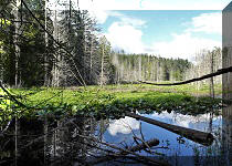
8-9. At 150 meters, the first of several long boardwalks begins, and it signals the arrival of a very impressive marsh. The sun needs to be out for the best views of this area.

Hike in Sechelt Area - Smuggler Cove Provincial Park

Smuggler Cove Marine Provincial Park near Sechelt BC Canada
10. Many thanks to resident beavers for creating this whole thing.

Smuggler Cove Marine Provincial Park Marsh
11. Reflections.

12. The first marsh ends, and the trail continues. At 260 meters now.

Smuggler Cove Trail in Sechelt British Columbia Area
13. The second marsh arrives shortly.

Wetlands in Smuggler Cove Provincial Park near Sechelt BC
14. Smuggler Cove Trail at 330 meters from the trailhead. Another marsh ahead.

Smuggler Cove Trail - Sunshine Coast British Columbia Canada
15-16. A beautiful marsh both right side up, and upside down.

Marsh in Smuggler Cove Marine Provincial Park

17. Numerous information stands keep things even more interesting.

Smuggler Cove Provincial Park Fungi Information Board
18. Now at 400 meters of Smuggler Cove Trail. It's a very easy and pleasant hike indeed.

Smuggler Cove Trail
19. And the wetlands just keep impressing.

Wetlands in Smuggler Cove Provincial Park by Sechelt BC
20. These marshes were created by beavers doing their thing.

Beaver Information Board
21. A beaver lodge a few meters away from the info stand.

Beaver Lodge
22. Lots of birds here too.

Song Birds of Smuggler Cove Marine Provincial Park
Our Smuggler Cove Trail Hike Trip Report Continues on Page 2.


|
 |
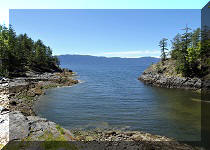
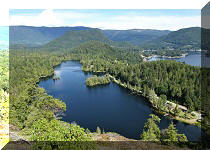
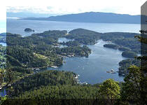
Other Trips on BC Sunshine Coast:
|
|
|
|
|
|
|
|
|
|
|

![]()
![]()
![]()
ihikebc.com Trip 257 - Smuggler Cove Trail Hike (Near Halfmoon Bay BC) Page 1 of 2