![]()
![]()
![]()

Trip 193 - August 31, 2020 (Monday) and September 8, 2020 (Tuesday).
Coliseum Mountain Trail Hike
Lynn Headwaters Regional Park (Near North Vancouver BC)
Page 3 of 3
Trailhead Location: In Lynn Headwaters Regional Park, Near Norvan Falls, closer to the end of Headwaters Trail (via Lynn Loop Trail and Cedar Mills Trail).
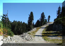
Liked: Mountain views, ponds/tarns, white stones in the alpine. Easy access trails through a pleasant forest to the Coliseum Mountain trailhead. Boardwalks on the access trails. Shade in the forest. Few bugs.
Of Note: Coliseum Mountain Trail is very challenging – for experienced and well-equipped hikers only. Numerous steep and slippery sections – hiking poles and boots are essential. Steep unbarricaded drop-offs at viewpoints. Several muddy sections. The access trails, which lead to Norvan Falls too, are popular. Park gate closes at a set time, and one must be able to leave prior to that. Parking could be an issue on busy days.
Vancouver, Coast & Mountains Backroad Mapbook (5th edition) Trailhead Coordinates: Page 11 (North Vancouver) E6.
103 Hikes in Southwestern British Columbia (2008 edition): hike #42.
Related Website: Lynn Headwaters Regional Park - Metro Vancouver Official Site.
Related Trip: 005 - Norvan Falls Hike.
59. The first viewpoint has two cairns, separated by approximately 100 meters. The first cairn is right by the path, on the left side. Coordinates: N 49⁰25.853' W123⁰00.102. Elevation: 1,289 meters (902 meters elevation gain from Coliseum Mountain trailhead).

Coliseum Mountain Trail in North Vancouver Area - first viewpoint
60. There are decent views from this point, and it would be a good final destination, if you are pressed for time. The hike to the second viewpoint and back would take another hour.

View from first viewpoint - Coliseum Mountain Trail - Hike in North
Vancouver Area
61. Now heading to the second cairn of the first viewpoint. This cairn is parallel to the first, and it would be on the right side, as you are hiking up the trail.

Coliseum Mountain Hike in North Vancouver Area
62. A neat tarn between the first and second cairns of the first viewpoint.

Hike in Lynn Headwaters Regional Park
63. And here is the second cairn of the first viewpoint.

Coliseum Mountain Hike - North Vancouver Hike
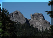
64. A very fine view from this point. A prominent peak in the middle back of the photograph is called Cathedral Mountain.

View from Coliseum Mountain - North Vancouver Hiking
65. A bit to the right.

Lynn Headwaters Regional Park
66. Proceeding to the main viewpoint.

Trail in North Vancouver Area - Coliseum Mountain
67. Seymour Lake is visible better and better on the right side, the higher you climb. It can actually be observed from the first cairn of the first viewpoint as well, but it's substantially obstructed by the trees there.

View from Coliseum Mountain - British Columbia Hiking
66. With much zoom, we see Seymour Dam.

Seymour Dam from Coliseum Mountain
67. Cathedral Mountain, also with a help of some zoom.

Cathedral Mountain
68-69. Getting close to the second viewpoint. Head towards this tree.


Coliseum Mountain Trail - Hike in British Columbia
70. A final climb.

Coliseum Mountain Hike
71. And we are there, at the second (and main) Coliseum Mountain viewpoint. Coordinates: N 49⁰26.035' W 123⁰00.398'. Elevation: 1,429 meters (1,042 meters elevation gain from Coliseum Mountain trailhead, and 1,235 meters elevation gain from the trailhead by the parking lot). Took us 5.5 hours to get here from the trailhead by the parking lot, and 4 hours from the Coliseum Mountain trailhead.

Main Coliseum Mountain Viewpoint
72-75. The views here are quite impressive. Left to right.


Coliseum Mountain
76. A panorama of the place.

Here is our video of the views from the main viewpoint.
More ihikebc videos are on our YouTube Channel.
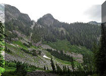
77. Hiking may continue for much longer here, but there is a large restricted watershed area nearby - consult a map to avoid trespassing. We ended up hiking counter-clockwise for about half a kilometer, and saw several impressive views.

Hike in Lynn Headwaters Regional Park
78. How about this tarn.

Lynn Headwaters Regional Park Hiking
79. And this is just a cool colour combination.

British Columbia Hiking
80. Here is a riddle - can you spot a prominent natural BC landmark in the photo below? It can be barely seen on the horizon. The next photo will reveal what it is.

Canada Hiking
81. Yeah, The Lions. Right side of the photo above.

The Lions
82. Speaking of colour combinations, Coliseum Mountain alpine area features copious amounts of very attractive white stone, and a combination of these stones with green grass, small colourful plants here and there, and blue sky is quite attractive indeed.

Coliseum Mountain British Columbia Canada
83. And one more.

Lynn Headwaters Regional Park British Columbia Canada
And then there was a return hike with a twice-rolled ankle and that sudden dive. Coliseum Mountain Trail has impressive views, but is challenging and complicated enough that it should be left for experienced, well-equipped hikers. A better alternative in North Vancouver area is Mount Seymour Trail - it has views which are just as good, if not better, and the trail is not nearly as dangerous, albeit substantially more crowded.


|
 |
Other Trips in North Vancouver Area:
|
|
|
|
|
|
|
|
|
|
|

Other Trips:


![]()
![]()
![]()
ihikebc.com Trip 199 - Coliseum Mountain Trail Hike (near North Vancouver BC) Page 3 of 3