![]()
![]()
![]()

Trip 131 - May 18-19, 2018 (Friday-Saturday)
Visit To Bella Coola BC
Also to Clayton Falls & Clayton Falls Recreation Area
Distance From Vancouver to Bella Coola: (via Highways
1 East, 97 North, and 20 West): approximately
1,000 kilometers.
Liked: Several neat buildings and totem poles, 24-hour car wash, wharf view, waterfall view, natural views from the Clayton Falls Recreation Area.
Of note: Waterfall is a dangerous area - swimming is not allowed. Camping is prohibited in the recreation area.
Cariboo Chilcotin Coast Backroad Mapbook (2015 edition) Coordinates: Page 22 (Bella Coola) D2.
Related Link: Town of Bella Coola (Wikipedia).
Other BC Cities, Towns and Locations We Have Visited: Agassiz, Bralorne, Chilliwack, Fort Nelson, Gibsons, Gold Bridge, Harrison Hot Springs, Hope, Horseshoe Bay, Merritt, Mission, Nanaimo (Old City Square), Port Alberni, Prince George, Prince Rupert, Smithers, Squamish, Telkwa, Tofino, Tumbler Ridge, Vancouver (Seawall), Vancouver (Stanley Park), West Vancouver (Ambleside Park).
At the end of our previous trip report, we have reached the town of Bella Coola, located at the western end of BC Highway 20. This trip report covers the town itself, as well as the nearby wharf/ferry terminal, Clayton Falls, and Clayton Falls Recreation Area. Bella Coola has a total population of about 2,000 people, and is home to Nuxalk aboriginal people. Aside from driving on Highway 20, it is possible to get to Bella Coola by taking a regularly scheduled flight from Vancouver (the airport is in nearby Hagensborg), or by boarding a ferry in Port Hardy (Northern Vancouver Island). There are many rundown buildings in Bella Coola, occasional garbage on the streets and old busted cars here and there, but, overall, it's a relaxed, slow-pace place in a beautiful setting, and the locals are friendly.
1. A sign (just before the bridge seen in the last photo of the previous trip report) indicates that turning to the right (after the bridge) would lead to the centre of Bella Coola, while the wharf could be reached by going straight.

BC Highway 20 West near Bella Coola British Columbia
2. Welcome to Bella Coola.

Welcome to Bella Coola sign
3. Bella Coola RCMP detachment.

RCMP Bella Coola Detachment
4. The centre of Bella Coola is very small, and consists of several blocks of businesses, including hotels (mostly along Mackenzie Avenue) and family houses. There is also a large totem pole across from the food store.

Totem Pole Bella Coola BC Canada
5. The Co-op food store on Mackenzie Avenue.

Bella Coola Co-op Food Store
6. Aboriginal art on the side of the store (across from the totem pole).

Bella Coola BC Aboriginal Street Art
7. Now looking down Mackenzie Avenue from the other side, with the Co-op food store visible on the far left.

Mackenzie Avenue Bella Coola BC Canada
8. Immediately to the left of where we took the photo above, there is a 24-hour car wash. If you are very quick, it is possible to wash your entire vehicle for one dollar.

Bella Coola Carwash
9. One of the family houses in Bella Coola.

Bella Coola British Columbia Canada
10. Bella Coola elementary school.

Bella Coola Elementary School
11. A neat-looking unknown building at 800 Mackay Avenue.

800 Mackay Avenue Bella Coola BC Canada
12-13. The following two photos were made in July of 2019, when we returned to Bella Coola, and found this fine piece of art on River Road.


Native Woman Totem Pole Bella Coola BC Canada
14. We are back on Highway 20, heading towards a wharf, about 3 kilometers from the center of Bella Coola.

BC Highway 20 in Bella Coola British Columbia Canada
15. It's a pleasant short drive.

BC Highway 20 between Bella Coola and Government Wharf
16. The wharf view is very picturesque.

Bella Coola Government Wharf
17. BC Ferry Northern Sea Wolf docking at the Bella Coola terminal. July of 2019 photo.

Northern Sea Wolf BC Ferry in Bella Coola
18. Just past the wharf, Highway 20 comes to its western end, and asphalt is replaced by gravel.

Western end of BC Highway 20 near Bella Coola Canada
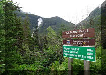
19. One and a half kilometers later, Clayton Falls Conservancy is in front of us. To the left is the beginning of Clayton FSR leading to M. Gurr Lake Trail, which we will cover in the next trip report. To the right is a short road which leads to Clayton Falls (eventually on the left side) and Clayton Falls Recreation Area (eventually on the right side).

Gravel Road West of Highway 20 near Bella Coola BC
20. Here is the very short path to Clayton Falls (to the left of the fence).

A path to Clayton Falls near Bella Coola BC Canada
21. Approaching the observation platform.

Approaching Clayton Falls Observation Platform near Bella Coola British
Columbia
22. Here is the observation platform. A sign advises against jumping into the falls and the creek, due to very strong currents.

Clayton Falls Observation Platform near Bella Coola BC Canada
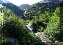
23. Clayton Falls.

Clayton Falls near Bella Coola BC
Here is our July of 2019 video of Clayton Falls.
More ihikebc videos are on our YouTube Channel.
24. A cool bench at the observation platform. The bench is dedicated to the memory of Wayne MacIntosh.

A Bench on the Clayton Falls Observation Platform
25. And this is the entrance to Clayton Falls Recreation Area, located on the other side of the short gravel road from Clayton Falls.

Entrance to Clayton Falls Recreation Area near Bella Coola British
Columbia Canada
26. Here is the parking lot. Alas, camping is not allowed.

Parking lot for Clayton Falls Recreation Area near Bella Coola BC Canada
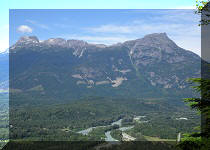
27. The views from the recreation area are very good.

View from Clayton Falls Recreation Area near Bella Coola British
Columbia
28. This body of water is called North Bentinck Arm.

North Bentinck Arm near Bella Coola BC Canada
29. There is this rusty ship nearby (much zoom used).

A Rusty Ship by Clayton Falls Recreation Area near Bella Coola in the
Province of British Columbia
The town of Bella Coola and its surroundings feature several fine views, and is certainly a good place to visit, if you would find yourself in the area.


|
 |
Other Trips in Bella Coola Area:
|
Schoolhouse
Falls East
|
|
|
|
|
|
|
Other Trips:


![]()


![]()
![]()
![]()
ihikebc.com Trip 131 - Town of Bella Coola Visit (Western End of BC Highway 20)