![]()
![]()
![]()

Trip 252 - May 23, 2022 (Monday)
Halliday Ridge Trail Hike
Mount Parke Regional Park
Mayne Island, British
Columbia
Liked: Several fine forest scenes, a fairly decent view from the top, shade in the forest, few bugs.
Of Note:
Steep unbarricaded drop-offs at the viewpoint, the view from the top is substantially overgrown, remote industrial noise at the viewpoint, uneven ground, roots and rocks, hiking poles and boots are recommended.Vancouver Island, Victoria & Gulf Islands Backroad Mapbook (9th edition) Trailhead Coordinates: Page 11 (Saturna Island) B2.
Related Websites: Wiki - Mayne Island, Mayne Island Community Website, BC Ferries Southern Gulf Islands Schedule.
Other Trips on Mayne Island: Mayne Island BC Visit, Campbell Point Trail.
Halliday Ridge Trail is inside Mount Parke Regional Park, which is located on Mayne Island, one of British Columbia's Southern Gulf islands.
A ferry from Tsawassen or Swartz Bay goes to Mayne Island. Then, the trailhead can be reached in about 4 kilometers via Village Bay Road, Felix Jack Road, Fernhill Road and Montrose Road.
Halliday Ridge Trail is easy-to-moderately challenging, and is just over 1.6 km one way. It has expansive ocean and islands views from the top, which are, unfortunately, substantially overgrown. If you want to see more impressive views and it does not have to be on Mayne Island, nearby Galiano Island has better hikes - Mount Galiano Trail and Bodega Ridge Trail.
All distances in this trip report are based on a GPS odometer and are approximate.
1. Here is a Google map with directions from Village Bay Ferry Terminal to Mount Parke Regional Park.
2. We are on Fernhill Road, about 3.9 km from the ferry terminal, getting ready to make a right turn onto Montrose Road. For more photo directions up to this point, check out Mayne Island Trip Report.

Fernhill Road at Montrose Road Mayne Island BC
3. In 250 meters, Montrose Road leads to Mount Parke Regional Park.

Montrose Road at Mount Parke Regional Park Mayne Island BC
Canada
4-5. Here is Mount Parke Regional Park and Halliday Ridge Trailhead. Coordinates: N 48°50.597’ W 123°16.784’. Elevation: 60 meters. A pit toilet is 370 meters down the trail.

Mount Parke Regional Park Halliday Ridge Trailhead Mayne
Island BC

Halliday Ridge Trailhead Mount Parke Regional Park Mayne
Island BC
6. Halliday Ridge Trail begins. 25 meters from the trailhead.

Halliday Ridge Trail Mayne Island BC Canada
7. A fine long boardwalk starts at 50 meters of the trail.

Halliday Ridge Trail - Hiking on Mayne Island BC
8. A birch tree grove is located near the boardwalk. At 70 meters here.

Mount Parke Regional Park Mayne Island BC
9. The boardwalk at 200 meters.
Mayne Island Hiking - Halliday Ridge Trail
10. Upon reaching the pit toilet at 370 meters, make a left turn (not pictured) into the woods. To the right would be a substantially wider gravel road - ignore. Here we are at 570 meters from the trailhead.

British Columbia Hiking - Halliday Ridge Trail - Mayne Island
BC
11. At 900 meters, Halliday Ridge Trail reaches a split. Keep right, as to the left there is a vast trail network which doesn't lead to the viewpoint.

Halliday Ridge Trail Mayne Island BC
12. A map is attached to a nearby tree. Halliday Ridge Trail is a blue line, and you are hiking from the top to the bottom on this map, so a right turn is in order. It's a confusing map in that it's North-oriented, and it appears a left turn needs to be made, but we need to turn right.

Glenwood Hiking Trails on Mayne Island BC
13. Halliday Ridge Trail at 1.08 km from the trailhead.

Hiking on Mayne Island BC - Halliday Ridge Trail
14. At 1.45 km, there appears to be a beginning of a small loop. We turned right.

Mount Parke Regional Parke Halliday Ridge Trail Mayne Island
BC Canada
15. At 1.6 km, we are almost there.

Halliday Ridge Trail Mayne Island BC
16. And here is the end of Halliday Ridge Trail at 1.63 km from the trailhead. Coordinates: N 48°50.280’ W 123°17.155’. Elevation: 190 meters (130 meters elevation gain from the start of the trail). Watch for steep unbarricaded drop-offs.

View from Halliday Ridge on Mayne Island
17. Now with a zoom.

Zoomed View from Halliday Ridge on Mayne Island British
Columbia Canada
18. An information stand describes all the good views that used to be here.

Mayne Island Halliday Viewpoint Information Board
19. Look up and see this...

Mayne Island BC
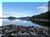
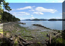
20-21. But not all is lost. There is still a spot not blocked by the trees. Plain and zoomed.

Halliday Ridge View Mayne Island BC

Zoomed View Halliday Ridge View Mayne Island BC
22. Plus, a neat bench.

Halliday Ridge Bench - Mayne Island BC
Here is our video of the views from this location.
More ihikebc videos are on our YouTube Channel.
Halliday Ridge Trail in Mount Parke Regional Park on Mayne Island is short enough, easy enough, pleasant enough, and leads to a decent enough view. Recommended.


|
 |
Other Trips:


![]()


![]()
![]()
![]()
ihikebc.com Trip 252 - Halliday Ridge Trail (Mayne Island BC)