![]()
![]()
![]()

Trip 253 - May 23, 2022 (Monday)
Campbell Point Trail Hike
Gulf Islands National Park Reserve
Mayne Island, British
Columbia
Liked: A short, easy trail to very fine views of Mayne Island shoreline (Bennett Bay) and Georgeson Island.
Of Note:
Hiking poles and boots are highly recommended for the shore exploration.Vancouver Island, Victoria & Gulf Islands Backroad Mapbook (9th edition) Trailhead Coordinates: Page 11 (Saturna Island) B2.
Related Websites: Wiki - Mayne Island, Mayne Island Community Website, BC Ferries Southern Gulf Islands Schedule.
Other Trips on Mayne Island: Halliday Ridge Trail, Mayne Island BC Visit.
Campbell Point Trail is located within Gulf Islands National Park Reserve on Mayne Island, one of British Columbia's Southern Gulf islands. A ferry from Tsawassen or Swartz Bay goes to Mayne Island, and then it's 6-7 kilometers to the trailhead via Village Bay Road, (turn right onto) Felix Jack Road, (turn right onto) Fernhill Road, and (turn left onto) Wilkes Road.
Campbell Point Trail is a short (700 meters) and easy hike through a pleasant forest to a very impressive shoreline of Mayne Island, where the key attraction is a small and pretty Georgeson Island, as well as Bennett Bay. It is possible to hike in a loop of sorts, by taking the regular trail to Campbell Point, and then returning via the shoreline, which is fairly complicated, with some seriously large stones, so hiking poles and boots would be very useful there.
All distances in this trip report are based on a GPS odometer and are approximate.
1. Here is a Google map with directions from Village Bay Ferry Terminal on Mayne Island to Campbell Point.
2. We are on Wilkes Road on Mayne Island, with Campbell Point trailhead parking lot turnoff seen on the right side.

Mayne Island Wilkes Road at Campbell Point Trailhead
3. Having turned right, here is the parking lot, with the trailhead on the left. Coordinates: N 48°50.825’ W 123°15.159’. Elevation: 10 meters.

Campbell Point Trailhead and Parking Lot
Mayne Island BC Canada
3. Campbell Point trailhead.

Mayne Island BC Hiking - Campbell Point Trailhead
4. And here is a map of the trail. We have parked our bicycle where it says "you are here". As you can see, there is another parking lot a bit further down the road. A pit toilet (and beach access) is located 300 meters from the trailhead.

Campbell Point Trail Map
5. Campbell Point Trail is a very easy hike. Here at 25 meters from the trailhead.

Campbell Point Hike - Maybe Island BC - Gulf Islands National Park Reserve
6. Now at 410 meters.

Hiking on Mayne Island - Campbell Point Trail
7. Just a pleasant walk among the trees, really. At 650 meters now.

Campbell Point Trail - Mayne Island - British Columbia - Canada
8. At 680 meters, we have reached a small glade, with a bench on the right side.

Campbell Trail Glade Mayne Island BC
9. Keep going straight for a few more meters down this small hill.

Campbell Point Trail - Mayne Island BC Hiking
10-14. And here is Campbell Point and Bennett Bay, featuring Georgeson Island. Coordinates: N 48°50.804’ W 123°14.642’. Elevation: 5 meters. Note that landing on Georgeson Island is prohibited. Left to right.

Campbell Point Mayne Island BC

View from Maybe Island BC Campbell Point

Campbell Point - Mayne Island - British Columbia

Georgeson Island BC

Bennett Bay Mayne Island BC
15. A panorama of the place.

Campbell Point Panorama - Mayne Island BC Canada
Here is our video of the views from this location.
More ihikebc videos are on our YouTube Channel.
16. If you are properly equipped and are comfortable handling complicated terrain, a good and very picturesque way to return to the parking lot is via the shoreline by making a right turn. At first, you have to tackle some serious stones, if for a brief stretch.

Mayne Island BC - Campbell Point
17. Then, it gets easier.

Campbell Point - Mayne Island British Columbia
18. Looking back at Georgeson Island.

Georgeson Island
19. Now looking forward.

Gulf Islands National Park Reserve - Mayne Island British Columbia
20-21. You can rejoin the main trail near the stone seen ahead by a small tree, by going to the right up a small hill.


22. But we kept going forward and reached a stony beach.

Mayne Island BC Gulf Islands National Park Reserve
23. It's a fine-looking beach too.

Campbell Point - Mayne Island - British Columbia - Canada
24. The stones soon end, and there is some hard-packed sand to be enjoyed.

Gulf Islands National Park Reserve - Mayne Island BC Canada
25. A ladder on the right side leads to that pit toilet at 300 meters of the trail, and then back to the trailhead.

Mayne Island BC
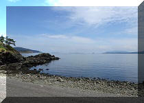
26. Having climbed to the top of the stairs we looked back, and isn't it pretty.

Campbell Point - Mayne Island - BC - Canada
Campbell Point Trail in Gulf Islands National
Park Reserve on Mayne Island has mightily impressed. Highly recommended.


|
 |
Other Trips:


![]()


![]()
![]()
![]()
ihikebc.com Trip 253 - Campbell Point Trail (Mayne Island BC)