![]()
![]()
![]()

Trip 081 - May 29-30, 2015 (Friday-Saturday)
Sikanni Chief Falls
Off Alaska Highway (BC Highway 97)
Page 2 of 2
Location: Northeastern British Columbia, 16th kilometer of Mile 171 (Grassy) Road off Alaska Highway (BC Highway 97), approximately midway between Fort St. John and Fort Nelson.
Liked: The waterfall, layered rock by the waterfall, meeting moose on Mile 171 Road, fairly good road conditions on Mile 171 Road (but also see "of note").
June 2016 Update: Mile 171 Road is now very rutted and potholed, though still quite passable in a high-clearance 2WD vehicle.
Of note: Remote area, no cell phone signal, steep cliffs at the waterfall viewing area, Mile 171 Road could be impassable in 2wd and/or low-clearance vehicles, unless it's dry. Also, there are no signs on Alaska Highway directing you to Sikanni Chief Falls, so you need to know exactly where to turn off the highway.
Northern BC Backroad Mapbook (3rd edition) Waterfall Coordinates: Page 73 (Pink Mountain) B6.
Related Website: Sikanni Chief Falls Protected Area - BC Parks.
Related Trip: Sikanni River Trail Hike.
Other Trips off Alaska Highway: Christina Falls Trail Hike, Stone's Sheep Trail Hike, Summit Ridge Trail Hike, Summit Peak Trail Hike.
>>> British Columbia Waterfalls Visits.
Follow @ihikebc Tweet
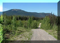
17. The path then goes through a forest for a few minutes.

Sikanni Chief Falls Trail British Columbia Canada
18. And, shortly, there is a split. Where the left path goes we don't know. The right path goes to the observation point. And the straight ahead path in the middle also leads to a fairly good view of the waterfall. However, the middle path is much steeper, the cliffs are not roped off, and the view is slightly worse than from the observation point. So, it makes sense to take the right path.

Photo of Sikanni Chief Falls Trail BC Canada
19. Here is the view of the waterfall from that paths split.

Sikanni Chief Falls Seen From The Trail
20. The path to the right.

Path to Sikanni Chief Falls British Columbia Canada
21. This path is quite short too.

Path to Sikanni Chief Waterfall off Alaska Highway in British Columbia
Canada
22. While walking on the path to the right, you have an option of taking a shortcut by turning to the left, hopping down some stones, and then observing impressive layered rocks.

Sikanni Chief Falls Provincial Protected Area BC Canada
23. Like this one.

Layered Rock Near Sikanni Chief Waterfall Viewing Area
24. And the waterfall is quite close after that. Of course, you can just follow the path without taking any shortcuts, and get to the layered rocks via the waterfall viewpoint.

Sikanni Chief Falls
25. Zooming in.

Sikanni Chief Waterfall off Alaska Highway in British Columbia Canada
26. Zooming all the way (12x).

Sikanni Chief Waterfall
Here is Our Video of Sikanni Chief Falls From Observation Area:
27. Then, there is an option of taking a path on the right side around the canyon, and getting to the top of the waterfall. Here is the view of Sikanni Chief Falls en route.

Sikanni Chief Falls Province of BC Canada
28. Another impressive layered rock.

Layered Rock Sikanni Chief Falls Provincial Protected Area British
Columbia Canada
29. By taking the path to the top of the waterfall, you would get a much better look at Sikanni Chief River past the waterfall (looking left here - the waterfall is to the right of where we are standing).

Sikanni Chief River BC Canada
30. Just before the top of the waterfall, the path gets steep, if for just a few meters. Hiking poles and/or boots would be useful here.

Sikanni Chief Falls Provincial Protected Area
31. Near the top of Sikanni Chief Falls.

Sikanni Chief River at the Top of Sikanni Chief Falls
32. ...

Sikanni Chief Falls View From the Top
Here is Our Video of Sikanni Chief Falls From the Top:
More ihikebc videos are on our YouTube Channel.
33. Heading back.

Sikanni Chief Falls Provincial Protected Area BC Canada
34. Hey, man, there are some trees on your nose!

Trees Growing on a Rock Resembling a Nose
35. Overall, it was a pleasant trip for sure.

Sikanni Chief Falls Provincial Protected Area British Columbia


|
 |
Other Trips off Alaska Highway / BC Hwy 97:
|
|
|
|
|
|
|
Other Trips:


![]()


![]()
![]()
![]()
Follow @ihikebc Tweet
ihikebc.com Trip 081 - Sikanni Chief Falls Visit (Off Alaska Highway / BC Hwy 97) Page 2 of 2