![]()
![]()
![]()

Trip 071 - September 5, 2014 (Friday)
Mount Seymour Trail Hike
Mount Seymour Provincial Park
Page 1 of 3
Distance From Vancouver (South End of Lions Gate
Bridge): Approximately 27 kilometers. Cross the Lions Gate Bridge and take the
North Vancouver exit. North Vancouver has the most confusing road
network in the entire Metro Vancouver, so forgive us for not giving
detailed driving instructions - use a map or a GPS to get to Mount
Seymour Provincial Park.
Liked: Great natural views - this is one of the most spectacular trails in Southwestern British Columbia. Panoramic views of Metro Vancouver.
Of note: The trail is very popular - expect substantial crowds on weekends and holidays. Hiking boots and poles are recommended to the first pump (peak), and are highly recommended to the second and the third (main) peak. The trail beyond the first peak is NOT recommended for hiking in wet and, especially, icy conditions. Tree cover is minimal - sun protection required. Ran into several nudists at Mystery Lake.
Vancouver, Coast & Mountains Backroad Mapbook (2010 edition) Coordinates: Page 11 (North Vancouver) G6.
103 Hikes in Southwestern British Columbia (2008 edition): hike #43.
Related Website: Mount Seymour Provincial Park - BC Parks Official Site.
Follow @ihikebc Tweet
Mount Seymour is so close to Vancouver that it's hard to even think of it as "wilderness", yet the trail to the peaks of Mount Seymour is exactly that. There are three peaks, and the trail goes by the first and second peaks before reaching the third and highest (true) peak of Mount Seymour.
You may get away without using hiking poles and boots if your final destination is the first peak, which offers very good views. However, if you choose to proceed further, the trail gets substantially more dangerous, and the look of concern we observed on the faces of some hikers was because they had difficulty maintaining balance going downhill without proper hiking equipment.
Finally, if it's wet and, especially, icy, consider not going beyond the first peak, as there are several very tricky spots later on, where falling into an abyss is a real possibility.
1. Drive to Mount Seymour Provincial Park (there is no public transit) and go to the upper parking lot, seen in the photo below.

Mount Seymour Provincial Park Parking Lot
2. Walk to the far end of the parking lot, where an information board (seen in the far middle of the photo below) is located.

Parking Lot - Mount Seymour Provincial Park BC Canada
3. The information board has a lot of useful advise, as well as this map. The letter P at the bottom left is where the upper parking lot is located, and you can see the entire Mount Seymour trail, with the main peak being at the elevation of 1453 meters.

Map of Mount Seymour Provincial Park
4. It gets confusing just beyond the stand, as there are four paths in this area, and the directional sign is somewhat unclear. But, we believe the choices for Mount Seymour Trail hikers are as follows: take the wide road on the far right (seen on the right side of the photo below) and get to Mount Seymour Trail via Mystery Lake (slightly longer)...

Mount Seymour Provincial Park BC Canada
5. ...or take the narrow path (second from the left, if you are facing all four paths in front of you) and go to Mount Seymour via the shortest trail. This narrow path is seen on the right side of the photo below. Coordinates: N 49⁰22.056' W 122⁰56.948'. Elevation: 1,014 meters.

Mount Seymour Provincial Park British Columbia Canada
6. This is what this narrow path looks like at the beginning.

North Vancouver Hiking - Mount Seymour Trail BC Canada
7. The path is quite rocky, but the grade is gentle.

Hiking Path Mount Seymour Provincial Park BC Canada
8. In about 25 minutes, you join a wide road, which...

Hike North Vancouver -
Mount Seymour Trail British Columbia Canada
9. ...very shortly leads to the Mystery Lake junction. Mystery Lake path is on the right, and Mount Seymour trail is on the left.

Mount Seymour Provincial Park BC Canada
10. Soon after the junction, the trail gets a bit steeper - you can see the trail in the middle of the photo.

Mount Seymour Hiking Trail BC Canada
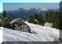
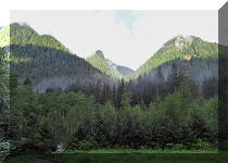
11. Twenty minutes after the Mystery Lake junction, you would reach Brockton Point. This could be a good destination of a short hike, because the views from Brockton Point are quite impressive.

Brockton Point Mount Seymour Provincial Park BC Canada
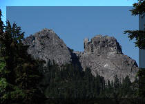
12. One of the impressive views from Brockton Point.

Photo of Mount of View from Brockton Point Mount Seymour Provincial Park
BC Canada
13a. Moving on.

Mount Seymour Hiking Trail near North Vancouver British Columbia Canada
13b. Here is the same area in the fog in 2021, when we hiked to Elsay Lake.

14. One hour and fifteen minutes into the hike, the Elsay Lake Trail junction arrives. Coordinates: N 49⁰23.171' W 122⁰56.173'. Elevation: 1,250 meters. Elsay Lake Trail is a long and tough hike.

Elsay Lake Trail Junction Mount Seymour Provincial Park British Columbia
Canada
15. Continuing towards Mount Seymour.

Mount Seymour Hiking Trail near North Vancouver British Columbia Canada
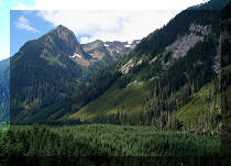
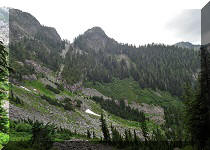
16. Twenty minutes after the Elsay Lake junction (and about one and a half hours after starting the hike), we approached the first pump (peak). From here, it's about 200 meters up a fairly gently-sloping rock. And this is also the point where great views arrive in earnest. The combination of green trees, colourful plants, blue skies, white rocks, and various mountain shapes looks very impressive.

BC Hiking - Mount Seymour Trail near First Pump (Peak)
Our Mount Seymour Trail Hike Report Continues on Page 2.


|
 |
Other Trips in North Vancouver Area:
|
|
|
|
|
|
|
|
|
|
|

Other Trips:


![]()


![]()
![]()
![]()
Follow @ihikebc Tweet
ihikebc.com Trip 071 - Mount Seymour Trail Hike (near North Vancouver BC) Page 1 of 3