![]()
![]()
![]()

Trip 193 - August 31, 2020 (Monday) and September 8, 2020 (Tuesday).
Coliseum Mountain Trail Hike
Lynn Headwaters Regional Park (Near North Vancouver BC)
Page 1 of 3
Trailhead Location: In Lynn Headwaters Regional Park, Near Norvan Falls, closer to the end of Headwaters Trail (via Lynn Loop Trail and Cedar Mills Trail).
Liked: Mountain views, ponds/tarns, white stones in the alpine. Easy access trails through a pleasant forest to the Coliseum Mountain trailhead. Boardwalks on the access trails. Shade in the forest. Few bugs.
Of Note: Coliseum Mountain Trail is very challenging – for experienced and well-equipped hikers only. Numerous steep and slippery sections – hiking poles and boots are essential. Steep unbarricaded drop-offs at viewpoints. Several muddy sections. The access trails, which lead to Norvan Falls too, are popular. Park gate closes at a set time, and one must be able to leave prior to that. Parking could be an issue on busy days.
Vancouver, Coast & Mountains Backroad Mapbook (5th edition) Trailhead
Coordinates: Page 11 (North Vancouver) E6.
103 Hikes in Southwestern British Columbia
(2008 edition): hike #42.
Related Website:
Lynn Headwaters Regional Park - Metro Vancouver Official Site. Related Trip:
Coliseum Mountain Trail/Route is located in Lynn Headwaters Regional Park in North Vancouver. This Regional Park has two entrances, and Coliseum Mountain Trail shares this entrance with Norvan Falls Trail, among other trails. In fact, you almost reach Norvan Falls, which would be only 300 meters further, before Coliseum Mountain Trail begins off Headwaters Trail. Lynn Headwaters is a very popular park, all the way to Norvan Falls, as the trails are fairly easy up to that point. But Coliseum Mountain Trail is a different animal altogether. It's very steep in several places, and slippery even when the ground is dry.
As camping is not allowed in Lynn Headwaters Park, the gate closes every evening, and the hike is quite long, one would have to start pretty much at the gate opening time to avoid rushing on this treacherous trail, especially if another hour would be spent visiting Norvan Falls, which would be better to do after the Coliseum Mountain hike (some people do it before, but save your energy for Coliseum Mountain, as you would likely need it).
We first hiked Coliseum Mountain trail on August 31st, hoping the sun would come out in the afternoon, but it took its time, and the fog lingered, so we headed back before reaching the end of the trail, in order to make it before the park gate would be closed. On September 8th, the weather situation was much better, and we ended up fully appreciating the fine views from Coliseum Mountain, despite some apparent haze/smoke in the vicinity.
Coliseum Mountain is not for novice or unprepared hikers. It's dangerous in many places. Despite having hiking poles and boots, and not being in a rush, during the hike on September 8th we have suffered a rolled ankle (twice), one stumble-and-fall (minor), and one slip-and-fall resulting in a 2-meter head/shoulder-first dive, with landing on top of a rather large stone. All the mishaps but the stumble-and-fall happened on the way down, and that's despite the fact that the ground was fairly dry, compared to August 31st. It's hard to remember when so much pain occurred on one hike, so, heads up - this trail is brutal, especially downhill.
1. This map, courtesy of Metro Vancouver, shows the trails of Lynn Headwaters Regional Park. One entrance to the park is at Grouse Mountain, and leads to several trails, and the other entrance is at Lynn Valley, which has a few more trails, including Coliseum Mountain. Haines Valley trail (a one-way hike) connects the two sets of trails.

Lynn Headwaters Regional Park Map
2. And this is a crop of the right side of the map, showing the trails leading to Coliseum Mountain trailhead, and the Coliseum Mountain Trail itself. The red circle is where we parked, the white square is where Cedar Mills Trail connects with Headwaters Trail, the red square is Coliseum Mountain trailhead, and the yellow square is the end of Coliseum Mountain Trail.

Map of Lynn Headwaters Regional Park - Lynn Valley Entrance
3. To get to Lynn Headwaters Regional Park (Lynn Valley entrance) from downtown Vancouver, drive West on Georgia Street.

Georgia Street Vancouver BC
4. Head towards Lions Gate Bridge by taking Stanley Park Causeway.

Georgia Street by Stanley Park
5. Cross Lions Gate bridge.

Lions Gate Bridge
6. After the bridge, make a right turn towards Marine Drive East / North Vancouver.

North end of Lions Gate Bridge
7. Within several hundred meters, make a left turn from Marine Drive onto Capilano Road.

Marine Drive at Capilano Road North Vancouver British Columbia
8. Drive on Capilano Road towards Highway 1 East ramp.

Capilano Road North Vancouver BC Canada
9. Take Highway 1 East ramp.

Capilano Road Highway 1 East Access
10. Drive on Highway 1 East to Exit 19 (Lynn Valley Road).

Highway 1 Exit 19 Lynn Valley Road
11. After exiting the highway, make a right turn onto Lynn Valley Road.

North Vancouver BC
12. Drive on Lynn Valley Road.

Lynn Valley Road
13. Go straight/right after reaching this stop sign.

Lynn Valley Road North Vancouver BC Canada
14. And now you are at the entrance to Lynn Headwaters Regional Park (Lynn Valley entrance). The gate is locked outside of park operating hours (7AM - 9PM today). Camping in the park is prohibited.

Lynn Headwaters Regional Park Entrance (Lynn Valley)
15. The access road goes for 700 meters, and passes several overflow parking lots before reaching the main lot. Parking could be an issue on a busy weekend, so a free shuttle is available. The access road is narrow and winding - watch for other traffic, cyclists and pedestrians.

Lynn Valley Regional Park (Lynn Valley entrance) access road
16. Arriving at the main parking lot. We came very early, and on a workday too, so there was a lot of space.

Lynn Valley Regional Park (Lynn Valley entrance) main parking lot
17. A sign with a cougar requests maintaining your distance from others.

Lynn Valley Regional Park (Lynn Valley entrance) North Vancouver British
Columbia Canada
18. A short path leads to all the trails. A neat bridge crosses Lynn Creek.

Lynn Valley Regional Park
19. A view from the bridge.

Lynn Creek
20. Warning messages by the trails.

Lynn Valley Regional Park Hiking Warning Boards
21. And here is the start. Coordinates: N 49⁰21.703 W 123⁰01.702. Elevation: 194 meters. Going straight is Lynn Loop Trail, leading to Cedar Mills Trail, which then connects with Headwaters Trail, which, eventually, leads to Coliseum Mountain trailhead approximately 7 kilometers from this point. Cycling is not permitted on these trails.

Lynn Loop Trail
22. Lynn Loop trail is flat and wide. Lots of people usually walk, jog, and exercise their off-leash dogs here.

Hike in Lynn Headwaters Regional Park - Lynn Loop Trail
23. This truck frame is still here. We last saw it over 11 years ago when hiking to Norvan Falls.

Old Truck Frame in Lynn Headwaters Regional Park
24. The same frame 11 years ago. Note how much thinner are the two trees in the front.

Lynn Headwaters Regional Park Old Truck Frame
25. Going straight/left at this intersection is the beginning of Cedar Mills Trail, 1.8 km from the start. Turning right would shortly lead to a T-junction, where a right turn would continue Lynn Loop Trail (and, eventually, lead back to the park entrance), while turning left would be the beginning of Headwaters Trail, which would parallel Cedar Mills Trail, until they meet at Third Debris Chute 2.1 km later, at which point Cedar Mills Trail would end, and Headwaters Trail would continue for 3 more kilometers to Coliseum Mountain trailhead. Headwaters Trail is rougher than Cedar Mills Trail (which, in turn, is narrower and a bit rougher than Lynn Loop Trail). So, if you plan to hike a very exhausting Coliseum Mountain Trail, taking Cedar Mills Trail from and to the park entrance would save some time and energy.

Cedar Mills Trail Start - Hike in Lynn Headwaters Regional Park
26. Cedar Mills Trail has several fine boardwalks, this being one of them.

Hike in North Vancouver Area - Cedar Mills Trail - Lynn Headwaters
Regional Park
27. Much of Cedar Mills Trail looks just like that - rather narrow, lots of stones, but, mostly, flat.

North Vancouver Hike - Cedar Mills Trail - Lynn Headwaters Regional Park
28. Here is another boardwalk.

Trail in North Vancouver Area - Cedar Mills Trail
29.And one more.

Cedar Mills Trail - North Vancouver Trail
30. Closer to the end of Cedar Mills Trail.

Cedar Mills Trail
31. Almost at the Third Debris Chute.

Hiking in North Vancouver - Cedar Mills Trail
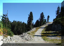
32. And we are there. Reached the opening seeing in the photo above, and turned to the right. This is the end of Cedar Mills Trail, and Headwaters Trail is straight ahead. Turning right would lead back to the park entrance, and turning left would result in reaching Coliseum Mountain trailhead in about 3 kilometers.

Third Debris Chute - Lynn Headwaters Regional Park - North Vancouver
Hiking
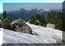
33. Looking back, we see a fine mountain view. This is the only mountain view on any of the trails leading to Coliseum Mountain trailhead.

Mountain View - Lynn Headwaters Regional Park
Our Coliseum Mountain Trail Hike Trip Report Continues on Page 2.


|
 |
Other Trips in North Vancouver Area:
|
|
|
|
|
|
|
|
|
|
|
|

Other Trips:


![]()
![]()
![]()
ihikebc.com Trip 199 - Coliseum Mountain Trail Hike (near North Vancouver BC) Page 1 of 3