![]()
![]()
![]()

Trip 033 - February 24, 2011 (Thursday)
Matsqui Trail Regional Park
Abbotsford BC
From Douglas Taylor Park to Page Road Trailhead (13.6 km)
Distance From Vancouver: About 57 km via
Highway 1 East to Mount Lehman Road exit in Abbotsford. Then, drive North for around 5 km, turn right
onto Harris Road, drive for less than 1 km, and turn left onto the parking lot of
Douglas Taylor Park. This is the Western end of the trail.
Liked: Rural vistas, well-maintained trail.
Of note: This trail is not a loop, some stretches were brutally windy, there was a lot of horse manure (watch your step).
Vancouver, Coast & Mountains Backroad Mapbook (2010 edition) Trailhead Coordinates: Page 3 (Abbotsford) C5.
A Similar Trail in Chilliwack: Chilliwack Dyke Trail.
Matsqui Trail runs along Fraser River in the town of Abbotsford, BC. To get there from Highway 1, take Mount Lehman Road exit, drive North for just over five kilometers, turn right onto Harris Road, and, in less than a kilometer, on the left side (across from Olund Road) you would see the entrance to Douglas Taylor Park, the Western end of the trail. Matsqui Trail is quite long - its Eastern end is at Page Road, 13.6 km later. However, there are five or six entrances/exits along the trail, which are all car-accessible. If you have two vehicles, you can do a one way trip.
Since we did not have a second vehicle, and did not want to return along the same trail, we took Abbotsford's rural roads to get back to the parking lot. It turned out to be a bad idea. There were few good views, and the last stretch (Westbound along Harris Road) forces you to walk on a narrow shoulder along a very busy two-lane road. Besides, we misjudged how long it would take to get back, and ended up running on that same shoulder for about 20 minutes to avoid our vehicle being locked in or towed from the Douglas Taylor Park's parking lot, since a note at the park entrance stated that the park closes one hour after the sunset, and it was around that time.
We would recommend walking this trail West to East, especially in the afternoon, as the sun would otherwise be shining straight into your eyes. Also, have a windbreaker and a head cover, especially if it is cold, and especially if you are going to walk East of Mission Bridge, where the wind was, at times, simply brutal.
1. We have exited Highway 1, and are now driving North on Mount Lehman Road.

Mount Lehman Road in Abbotsford BC Canada
2. Just over five kilometers later, you would come to a four-way stop intersection with a red light. This is Harris Road. Turn right.

Intersection of Mount Lehman Rd and Harris Rd in Abbotsford British
Columbia Canada
3. Less than a kilometer later, on the left side of Harris Road, there is the Douglas Taylor Park entrance, located across from Olund Road. This park is open one hour prior to sunrise to one hour after the sunset.

Douglas Taylor Park Entrance Abbotsford BC Canada
4. Here is the map of the entire trail. Technically, this is not Matsqui Trail yet, as you have to walk a few kilometers on Olund Trail to reach Matsqui Trail. But it does feel like one trail, anyway. The inset at the bottom of the page shows Mission Bridge area of the Matsqui Trail Regional Park. The red triangle on the left side of the map shows our current location. The end of our trip would be 13.6 km later at the Page Road Trailhead.

Matsqui Trail Map Photo
5. Off we go. The first part of the trail goes mostly through a forested area, with a field appearing on the left for a brief period of time. In a few minutes, a sign would advise that we are entering Matsqui First Nations land.

Olund Trail en route to Matsqui Trail Abbotsford Province of BC Canada
6. Forty minutes later, we are in the open. Several horses were available for observation near a shed on the right side. Straight ahead is a sewage treatment plant (thank you for identifying, "109 Walks in Southwestern British Columbia by Mary & David Macaree") with an unmistakable (though faint) smell.

Abbotsford Hiking - British Columbia Canada
7. As we were walking along the wide path seeing in the photo above, to our right there was a very impressive mountain, as well as trains passing by. Substantial zoom used.

CN Train Engine in Abbotsford BC Canada
8. The promised sewage treatment plant along the path.

Sewage Treatment Plant along Matsqui Trail - Hiking in Abbotsford British
Columbia Canada
9. Then, the path went through more trees, and, an hour and fifteen minutes after we started the hike, arrived to the main entrance to Matsqui Trail Regional Park - Mission Bridge. Parking, camping (April through October), fishing, washrooms, and picnic tables are available.

Mission Bridge seen from Matsqui Trail in Abbotsford BC
10. A railroad bridge is just beyond the vehicle bridge, as you keep walking East.

A Railroad Bridge seen from Matsqui Trail - Abbotsford British Columbia
Canada
11. The stretch from Mission Bridge to Page Road trailhead can be taken in the open on the levee, or to the left through the woods (though the levee would then block off all the good views on the right).

Abbotsford Hiking - Matsqui Trail Regional Park in British Columbia Canada
12. Another great-looking mountain accompanies you for much of this stretch of the trail. Substantial zoom used.

Mountain View seen from Matsqui Trail in Abbotsford British Columbia
Canada
13. Do note that you are now in the open, with no tree cover, and the wind around here was simply ferocious. As the temperature was around zero, it was very cold. For much of the way past the Mission Bridge, there is also a trail in the woods close to Fraser River to the left of this path, and there is some tree cover there. But you would lose many great views.

The path of Matsqui Trail Regional Park - Hiking in Abbotsford BC
14. A fine rural scene to our left.

View from Matsqui Trail Abbotsford BC
15. Getting closer to the end. A thoughtfully placed bench and a washroom for a weary traveler.

Matsqui Trail close to Page Road Trailhead - Abbotsford Hike in BC Canada
16. We are at the Page Road trailhead now, and are looking back West. Do note the 6 PM closing time this time of the year.

Looking West on Matsqui Trail from Page Road Trailhead - Hiking in
Abbotsford BC
17. As mentioned above, we took Abbotsford streets (Page Road, Riverside Street, then Harris Road) to get back to our vehicle. Not too many great views, but still some good vistas. Here is one. Some zoom used.

Mountain seen from Page Road Abbotsford BC Canada
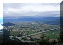
18. And another photo of rural living in Abbotsford, British Columbia.

Abbotsford BC Photo
Provided you are ready for the wind, this is a very pleasant hike and is definitely recommended.


|
 |
Other Trips in Abbotsford Area:
|
|
|
|


Other Trips:


![]()


![]()
![]()
![]()
Follow @ihikebc Tweet
ihikebc.com Trip 033 - Matsqui Trail Regional Park (Abbotsford BC)