![]()
![]()
![]()

Trip 265 - September 5, 2022 (Monday)
Red Rock Canyon Trail Hike
North of Fort Nelson BC / Near Muncho Lake BC
Page 1 of 2
Of Note: Extreme fall danger at the top of the waterfall – stay away from the edge, wading for a long distance would be required in high water conditions, several creek crossings are required, steep unbarricaded drop-off for several hundred meters before the waterfall top view, some trail parts are overgrown – long pants and a long-sleeved shirt are recommended, uneven ground, numerous loose rocks, some steep sections, hiking poles and boots are essential.
Northern BC Backroad Mapbook (3rd edition) Approximate Trailhead Coordinates: Page 79 (Muncho Lake) E4.
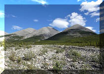
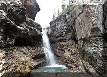
Red Rock Canyon Trail (not to be confused with Red Rock Trail in Lillooet) is located in Northeastern British Columbia by BC Highway 97 (Alaska Hwy) just South of Muncho Lake, which, in turn, is about 245 km North of Fort Nelson. You basically hike up a creek to a small canyon with a rather impressive 15 meter-high waterfall. As we hiked at the end of the season, the water level was low, and we were able to stone-hop in a few locations while crossing the creek and, also, when approaching the bottom of the waterfall at the end of the 200 meter-long canyon. Earlier in the season, or after a heavy rainfall, chances are pretty good that much wading would have to be done while hiking this 2.6 km-long (one way) trail. There are actually three viewpoints: 1) the waterfall view from the path about 100 meter away; 2) the top waterfall view; and 3) the bottom waterfall view via the canyon. Extreme caution must be used when checking out the top waterfall view, as you need to get pretty close to the edge for a better look, and the ground is slanted towards the canyon with nothing to hold on to. It's a very high fall hazard - watch out. There is also a fairly dangerous stretch as you approach the top view, due to a steep unbarricaded drop-off by the path.
Also, there are some overgrown sections, so having a long-sleeved shirt and long pants would save from minor skin damage. The hike steadily gains elevation, but nothing too major as far as steep stretches. It does get very steep as you descend for a few meters towards the top view, but just go past that descent for a minute or so, and you will get to a much easier descent path close to the end of the trail (which is 100 meters past the waterfall top view).
*All trail distances are based on a GPS odometer and are approximate.
1. Here is a Google Maps location of Muncho Lake. Red Rock Canyon Trail is located just to the South of Muncho Lake.
2. We are Northbound on BC Highway 97 (Alaska Hwy), approaching a sign indicating Muncho Lake services are 3 to 10 km ahead.

Alaska Highway (BC Highway 97) near Muncho Lake British Columbia Canada
3. Just a bit further there is a turnoff to Red Rock Canyon trailhead, which is located right by the highway. This turnoff is exactly 8 km North of Peterson Canyon North trailhead, with Peterson Canyon being the subject of our previous trip report.

BC Highway 97 at Red Rock Canyon Trail Parking Area near Muncho Lake BC
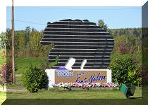
4. We will return to Red Rock Canyon Trail shortly, but now we are going to check out a bit of Muncho Lake. Here is the community sign, 600 meters past the Red Rock Canyon trailhead turnoff.

Muncho Lake BC Canada
5. A gas station at the South end of Muncho Lake. The pumps were broken, so we had to go to the North end, where there is the only modern pump (i.e. accepting credit cards right at the pump) North of Fort Nelson that we could find, located at the Northern Rockies Lodge. Hopefully, once the pumps are fixed here, the price of gas would be a bit less at this station than at the lodge, where it was 2.50 per litre, about 50 cents per litre more than in Vancouver, and 20 cents per litre more than in Toad River 50 km to the South.

Muncho Lake Gas Station
6. A sign at the gas station advertises a local towing service. As there is no cell signal for a long, long distance around here, a sat phone is your friend (or use InReach and ask someone you know or the emergency centre to call this number for you).

Muncho Lake Towing Service
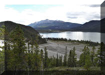
7. Muncho Lake is a looker for sure.

Muncho Lake
8. And here is the Northern Rockies Lodge on the northern end of Muncho Lake, with the most expensive gasoline in North America that we know of. The pump is on the right side (not seen in the photo below). They do offer 20 cents per litre off to anyone staying at the lodge. There is also a very small store inside. They did have ice.

Northern Rockies Lodge Muncho Lake British Columbia Canada
9. Back at the Red Rock Canyon trailhead, with BC Highway 97 just behind us. Coordinates: N 58°55.351’ W 125°46.248’. Elevation: 880 meters. Plenty of parking.

Red Rock Canyon trailhead
10-11. The info board.

Red Rock Canyon Trail Information Board

Red Rock Canyon Trail Map
12. The hike begins. 25 meters from the trailhead.

Red Rock Canyon Trail near Muncho Lake BC
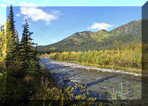
13. At 60 meters, we are already hiking by the creek. Follow it upstream to reach the waterfall about 2.6 km later.

Northern British Columbia Hiking - Red Rock Canyon Trail
14. At 310 meters, the path ended and we started hiking on the creek bed.

Red Rock Canyon Hike North of Fort Nelson BC
15. At 430 meters now.

Hiking Red Rock Canyon Trail by Muncho Lake BC Canada
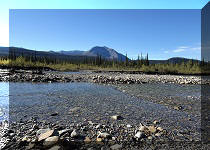
16. At 635 meters from the trailhead, we are still hiking up the creek bed. Earlier in the season, there could be a lot of water here.

Muncho Lake Hiking - Red Rock Trail British Columbia
17. Red Rock Canyon Trail path briefly reappeared. At 775 meters now.

Hike in British Columbia - Red Rock Canyon Trail
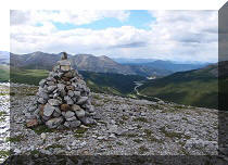
18. There is an occasional cairn (seen in the bottom right) and a flagging tape here and there, but, as long as you hike up the creek, you will get to the canyon and the waterfall. At 870 meters from the trailhead.

Red Rock Canyon Trail near Muncho Lake BC Canada
19. At 1.16 km, we are still hiking up the creek bed.

Red Rock Canyon Hike in Muncho Lake BC Area
20-21. At 1.71 km, a creek crossing is in order. Hiking poles and boots are essential for this hike.


Hiking Red Rock Canyon Trail in Northern British Columbia Canada
22. At 1.80 km, we are approaching the most interesting part of the hike.

Red Rock Canyon Trail
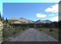
23. At 2.02 km, the path reappeared and we started to climb up.

Muncho Lake Hiking - Red Rock Canyon
24. At 2.06 km of the Red Rock Canyon Trail.

Red Rock Canyon Trail North of Fort Nelson BC
25. At 2.30 km, the path came down back to the creek.

Red Rock Canyon British Columbia
26. At 2.31 km, we are back in the creek bed.

Red Rock Canyon Trail BC Canada
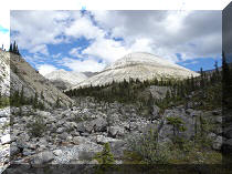
27. At 2.34 km, we are approaching a key split.

Red Rock Canyon near Muncho Lake BC
28. Here is this key split at 2.36 km of Red Rock Canyon Trail, at this small waterfall. Coordinates: N 58°54.760’ W 125°44.935’. Elevation: 935 meters.

Red Rock Canyon Hike
29. At this split, going straight leads to the bottom of the waterfall (via the canyon) within 200 meters, while going to the right leads to the viewpoint in 100 meters, and the top of the waterfall in 200 meters.

Red Rock Canyon Trail Hike Split
30. We went to the right at first.

Red Rock Canyon Hike off Alaska Highway in British Columbia
Our Red Rock Canyon Trail Hike Continues on Page 2.


|
 |
Other Trips in Fort Nelson Area:
|
|
|
|
|
|
|
|
|
|
|
|
|
|
|
|
Other Trips:


![]()
![]()
![]()
ihikebc.com Trip 265 - Red Rock Canyon Trail (By Muncho Lake North of Fort Nelson BC) Page 1 of 2