![]()
![]()
![]()

Trip 224 - July 15, 2021 (Thursday)
City of Port Alberni Visit
On Vancouver Island, British Columbia, Canada
Page 2 of 2
Liked: Natural views, aboriginal street art, wall murals, banners on light posts, artistic trash cans, wide streets.
Of Note: Very windy by the water. Port Alberni is located in a Tsunami Hazard Zone.
Vancouver Island Backroad Mapbook (9th edition) Port Alberni Coordinates: Page 17 (Port Alberni) B1-B2.
Related Websites: City of Port Alberni - Official Website,
Wiki - Port Alberni, Google Maps - Port Alberni.Other Trips in Port Alberni Area: Cold Creek Falls Trail, Jack's Peak Trail.
Other BC Cities, Towns and Locations We Have Visited: Agassiz, Bella Coola, Bralorne, Chilliwack, Fort Nelson, Gold Bridge, Harrison Hot Springs, Hope, Horseshoe Bay, Merritt, Mission, Nanaimo (Old City Square), Prince George, Prince Rupert, Smithers, Squamish, Telkwa, Tofino, Tumbler Ridge, Vancouver (Seawall), Vancouver (Stanley Park), West Vancouver (Ambleside Park).
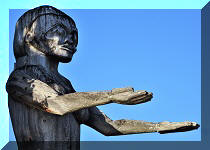
The City of Port Alberni bills itself as the fishing capital of Canada, and is located on BC Highway 4, between the East Coast of Vancouver Island (42 km away) and the West Coast oceanside communities of Tofino and Ucluelet (about 120 km away). It's a cozy small city, where about 17,000 people currently reside. Today, we visited Victoria Quay, Harbour Quay, and what appeared to be downtown area centered around the intersection of 3rd Avenue and Argyle Street. We found wide streets, few people, fine natural views, and a whole lot of art, from an aboriginal Welcome Figure at Victoria Quay, to very impressive wall murals, to highly enjoyable street light banners, and even several very well-decorated garbage cans.
There is also an assortment of major stores in Port Alberni, including a Wal-Mart, and this city is your last chance to stock up on a whole lot of things not available in much smaller Tofino and Ucluelet further West down BC Highway 4. As Port Alberni is located in a tsunami hazard zone, head to the higher ground in case of an earthquake.
35. One block closer to Harbour Quay, we are on Kingsway Avenue at 3rd Avenue, looking East. There is yet another good wall mural to the left. And, further down the street on the right side, is a former Port Alberni railway station, which looks like it was turned into a museum.

Kingsway Avenue at 3rd Avenue Port Alberni BC Canada
36. Port Alberni railway station. Apparently, once a year railroad enthusiasts do run a train to and from this location.

Port Alberni Railway Station
37. A nearby information board contains a photo of the first train ever to arrive to Port Alberni in 1911.

First Train in Port Alberni BC
38. Inside the Port Alberni railway station (through a window).

Inside Port Alberni Railway Station
39. Now it's time to check our Harbour Quay. It's a less than a ten minute walk from the intersection of 3rd Avenue and Argyle Street. There are several shops and eateries there, a large (and VERY windy) pier, an old ship turned into a bed-and-breakfast, and a cool 15-meter-high tower with panoramic views of the nearby area. Very close by is Maritime Discovery Centre located in a lighthouse-shaped building, as well as Maritime Heritage Gallery. There is also a marina and a short seawall promenade area.

Port Alberni Harbour Quay Entrance
40. Before we go further, yet another impressive banner on a light post.

Light Post Banner Port Alberni BC
41. Here is Port Alberni Harbour Quay main shopping area. Argyle Street (where we came from) is seen straight ahead, the pier is right behind us, and the tower is behind us and more to the right.

Harbour Quay Port Alberni British Columbia
42. Let's check out the tower first. It's about 15 meters high, and the observation platform is at about 10 meters from the ground. Coordinates for the tower observation platform:
N 49⁰14.091' W 124⁰48.965'. Elevation: 10 meters.

Port Alberni Harbour Quay Tower
43. The access to the tower.

Access to Port Alberni Harbour Quay Tower
44-49. The views from the tower, left to right.


Harbour Quay Port Alberni

Port Alberni Harbour Quay

Port Alberni BC Harbour Quay

Harbour Quay Port Alberni British Columbia Canada

View from Port Alberni Harbour Quay Tower
Here is our video of the views from the tower.
50. Now we are at Centennial Pier.

Centennial Pier - Harbour Quay - Port Alberni BC
51. Notice to users.

Port Alberni Centennial Pier Notice to Users
52. RCMP boat Lindsay docked at the pier.

RCMP Boat Lindsay in Port Alberni BC
53. Another Port Alberni thing - artistic trash cans. Haven't seen anything this beautiful anywhere in British Columbia, with, perhaps, the only exception being Tofino trash cans.

Artistic Trash Can Port Alberni BC Canada
54. The vessel seen in the distance in the photo above is a spill response boat Barkley Sentinel.

Barkley Sentinel Spill Response Vessel Port Alberni British Columbia
55. Proceeding to Centennial Pier. Super windy out there. Water splashes all over the place.

Port Alberni BC Centennial Pier
Here is our video of the views from this location.
More ihikebc videos are on our YouTube Channel.
56. MV Songee is docked at Centennial Pier, and has been turned into Swept Away Inn Bed-and-Breakfast.

MV Songee - Swept Away Inn Bed-and-Breakfast - Centennial Pier- Harbour
Quay - Port Alberni BC - Canada
57. This trash can seriously belongs in an art gallery.

Centennial Pier Artistic Trash Can Port Alberni BC
58. The rest of Centennial Pier. Lots of benches.

Centennial Pier Port Alberni
59. Looking to the right.

View from Centennial Pier in Port Alberni British Columbia Canada
60. Now we have turned around and are looking to the right in the opposite direction.

Port Alberni Centennial Pier
61. Zooming in, we see Port Alberni Maritime Discovery Centre in a lighthouse-shaped building.

Port Alberni Maritime Discovery Centre
62. Heading towards Maritime Discovery Centre along a short promenade.

Harbour Quay Promenade in Port Alberni British Columbia
63. Welcome to the heart of Vancouver Island.

Port Alberni Welcoming Trash Can
64. Passing by Harbour Quay Marina.

Harbour Quay Marina Port Alberni British Columbia Canada
65. Getting closer to Maritime Discovery Centre.

Maritime Discovery Centre Port Alberni BC
66. Make a right turn...

Port Alberni BC Path to Maritime Discovery Centre near Harbour Quay
67...go by Maritime Heritage Gallery...

Port Alberni Maritime Heritage Gallery
68...and here is Port Alberni Maritime Discovery Centre.

Port Alberni Maritime Discovery Centre
For such a small town, Port Alberni has a lot of impressive man-made and natural attractions. Highly recommended.


|
 |
Other Trips:


![]()
![]()
![]()
ihikebc.com Trip 224 - City of Port Alberni Visit (Vancouver Island BC) Page 2 of 2