![]()
![]()
![]()

Trip 008 - December 28, 2009 (Monday)
Campbell Lake Trail Hike
Near Harrison Hot Springs, BC
Page 2 of 2
Distance From Vancouver: 135-140 km. The trail
begins in Harrison Hot Springs.
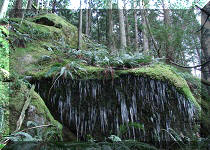
Liked: Fairy-tale forest scenes, icicles on rocks, view of Harrison Lake.
Of note: Occasional ice patches, fairly cold in the winter, snow in higher elevations.
Vancouver, Coast & Mountains Backroad Mapbook (2010 edition) Trailhead Coordinates: Page 4 (Chilliwack) F1.
103 Hikes in Southwestern British Columbia (2008 edition): hike #61.
15. Approaching this tree, it looked like someone used it for a shotgun shooting practice. But no, it's just the way the bark looks.

Campbell Lake Trail British Columbia Canada
16. And then there was this ladder, which looked very good from afar...

BC Hiking -
Campbell Lake Trail
17. ...but, after getting closer, you realize that not even a world-class figure skater would be able to go up this substantial piece of ice. Solution: climb from the side.

Campbell Lake Trail - Hiking in BC
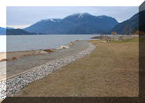
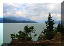
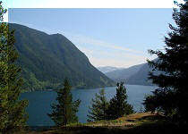
18. If you are successful in getting past the ice challenge, your reward is this view. It is a slightly zoomed photo. The trail map refers to a helipad, but none was seen in the area.

Harrison Lake
19. Zooming in a bit more. This is Harrison Lake.

Harrison Lake and Mountains seen from Campbell Lake Trail BC Canada -
Hiking in Harrison Hot Springs Area
20. The view above is the main destination of the Campbell Lake Trail. But, if you feel like visiting the lake itself, proceed further for about thirty more minutes. The main obstacle arrives soon - a log bridge with damaged railing. Look at the snow on the log and the boulders below - a recipe for a nasty fall. So, use the stones by the log, but be very careful - it is a dangerous area.

British Columbia Hiking -
Campbell Lake Trail - log bridge
21. After that, we are in the winter forest.

Campbell Lake Trail by Harrison Hot Springs - BC Hiking
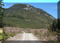
22. After the forest, a relatively open area awaits.

Hiking in BC -
Campbell Lake Trail photo
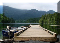
23. Near Campbell Lake, ATV tracks could be seen on the ground, as there is ATV access to the lake from another side. The ATV did some donuts on Campbell Lake.

Campbell Lake - British Columbia Canada
24. And we wish you a Merry Christmas!

It is possible to make this trip in six hours, though frequently stopping to take the pictures and admire the views would extend the hike accordingly.


|
 |
Other Trips in Harrison Hot Springs Area:
|
|
|
|
|
|
|
|
|
|
|
|
Other Trips:
ihikebc.com
Trip 008 -
Campbell Lake Trail Hike
(near Harrison Hot Springs)
Page 2 of 2


![]()


![]()
![]()
![]()