Trip 073 - September 12, 2014 (Friday)
Crown Mountain Trail Hike
Lynn Headwaters Regional Park
Page 1 of 2
Distance From Vancouver
(South End of Lions Gate Bridge) to Grouse Mountain parking lot:
7.4 km. Turn left onto Capilano Road in North Vancouver right after
crossing the Lions Gate Bridge. Or use Capilano Road exit from Highway 1 and go
North. Upon arriving to the Grouse Mountain parking lot, either take a gondola
or hike up via
Grouse
Grind (a very tough trail) to the
Grouse Mountain Recreational Area. Then,
follow the signs to the bear habitat, and, upon
reaching a fork with three roads, take the middle one to reach the
trailhead in about 5 minutes. Our
Goat Mountain Trail Hike
trip report has the exact directions to the trailhead.
Liked: Mountain views, the views of Metro Vancouver, and available hiker registration.
Of note: Crown Mountain is a dangerous trail, and is for experienced hikers only. Hiking boots and poles are essential. Not recommended for hiking, unless the ground is dry. The trail is popular. Getting to the trail means hiking The Grind first, or paying a substantial price for a gondola ticket. On the return trip, one must pay $10 for Gondola to go down, as downhill travel on The Grind is prohibited.
Vancouver, Coast & Mountains Backroad Mapbook (2010 edition) Coordinates: Page 11 (North Vancouver) D7-D6.
Related Website: Lynn Headwaters Regional Park - Metro Vancouver official site.
Crown Mountain Trail is located in Lynn Headwaters Regional Park, and is accessed through the Grouse Mountain entrance. This is by far the most dangerous and challenging hike we have done up to and including the year 2014. Though you don't see much until the end of the trail, the views from the top are excellent. Be careful, though - aside from the challenge of the trail itself, the peak of the mountain is very steep and narrow, and accommodates only one person at a time.
Follow @ihikebc Tweet
0a-0b. Here is a map of the Crown Mountain Trail, courtesy of Metro Vancouver Regional Parks.
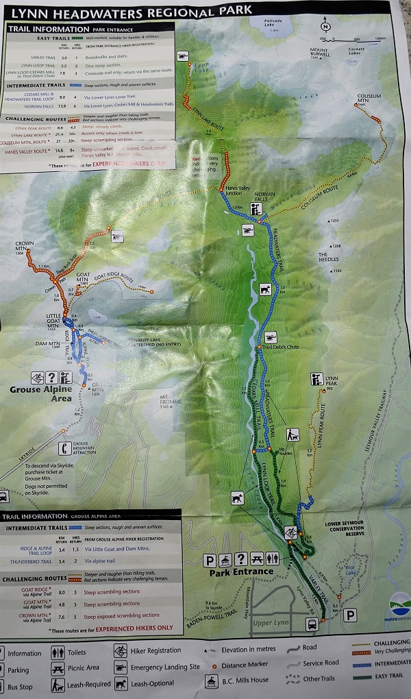
Lynn Headwaters Trails Map

Crown Mountain Trail Map
1. We took Grouse Grind to get to the trailhead, and our time today was 1 hour 11 minutes.

Grouse Grind Timer
2. Once you get to the top, you still need to walk for just over one kilometer to get to the hiking area. There are no signs pointing in that direction, so follow the painted footsteps to the grizzly bear habitat.

Grouse Mountain Recreational Area BC Canada
3. For detailed instructions on how to get to the trailhead, check out our Goat Mountain Hike Trip Report. You would eventually reach this information stand, which was moved a few hundred meters back. This is where you can register for your hike, so that the rescuers would know on which of the numerous trails to look for you, if needed.

Lynn Headwaters Regional Park Information Stand at Grouse Mountain
Recreational Area
4. The hike starts. Note, that there are no signs to Crown Mountain until further down the trail, so keep going without taking any side trails, and you'll get there.

North Vancouver
Hiking - Grouse Mountain Recreational Area BC Canada
5. A few stretches of the Ridge (or Alpine?) Trail are challenging, but it's child's play compared to what awaits you on the Crown Mountain trail.

Hiking Trail Grouse Mountain Recreational Area British Columbia
6. Forty minutes past the info stand, the Crown Mountain appears on your right side.

Crown and Camel Mountains Seen From Hiking Trail Grouse Mountain
Recreational Area BC Canada
7. Only the left peak is climbable (the actual Crown Mountain), and that's where we are heading today. The right peak is called The Camel.

Photo of Crown Mountain and Camel Mountain
8. One hour into the hike, there is a split. To the right is the trail to Goat Mountain and Goat Ridge, while to the left is the way to Crown Mountain and Hanes Valley.
9. Here is the split. We took the path to the left. This is where the tough hiking really begins.

British Columbia Hiking - Crown Mountain Trail near North Vancouver
10. And, right away, the final glimpse at the destination before you actually get there.

Hiking in North Vancouver Area - Crown Mountain Trail
11. What happens next is that, first, you descend down a very steep terrain, and, then, after you reach the Hanes Valley Route split, you climb up an equally steep terrain. We are descending here.

Crown Mountain Trail - Hiking in BC Canada
12. There are chains to assist through some stretches, but hiking this trail when the ground is wet or, let alone, icy, would be asking for trouble. Still descending.

Chains on Crown Mountain Hiking Trail BC Canada
13. Forty minutes after the Goat Mountain split, having done all the descending, you reach the Hanes Valley Route split (a one-way route to the second part of Lynn Headwaters Regional Park, where Norvan Falls etc is located), and begin your ascent.

Crown Mountain Trail Split With Hanes Valley Split BC Canada
14. Lots of roots.

North Vancouver Hike -
Crown Mountain Trail BC Canada
15. And lots of rocks.

Crown Mountain Hiking Trail Province of BC Canada
16. Some views are starting to appear.

Photo of Crown Mountain Hiking Trail BC Canada
17. Including the views of Metro Vancouver.

Metro Vancouver Seen From Crown Mountain Hiking Trail BC Canada
18. The path then goes through one of the most dangerous stretches. It looks rather easy in this photo, but...

Crown Mountain Hiking Trail British Columbia Canada
19. ...in fact, you are one slip away from tumbling down.

Crown Mountain Hiking Trail BC Canada
20. Another steep stretch, and...

Crown Mountain Hiking Trail Province of British Columbia Canada
21. ...there is one more rock field to cross.

Crown Mountain Hiking Trail BC Canada
Our Crown Mountain Trail Hike Trip Report
Continues on Page 2.
Other Trips in North
Vancouver Area:
ihikebc.com
Trip 073 - Crown Mountain Trail Hike
(near North Vancouver BC)
Page 1 of 2


![]()

