![]()
![]()
![]()

Trip 154 - May 9, 2019 (Thursday)
Millennium Trail Hike
Delta, British Columbia,
Canada.
Distance from Vancouver: Approximately 15 kilometers.
Liked: Farm field views, marina views, golf course views, art pieces near the marina, meeting several rabbits.
Of Note: Constant traffic noise, limited tree shade.
Vancouver, Coast & Mountains BC Backroad Mapbook (2nd edition) Coordinates: Page 1 (Vancouver) E5.
Millennium Trail starts at Deas Island Regional Park. It passes by a large farmer's field, then by a townhouse complex, then skirts by Highway 99 near Massey Tunnel, and splits in two after crossing a small pedestrian bridge: to the right is a picturesque walk along Captain's Cove Marina, and, to the left, is a fine path going by some townhouses, followed by a golf course. It's a rather short trail, 3.5 to 5.5 km one way (depending on whether you explore one or both splits), which offers several fine views, a few rabbits, and an unexpected high-quality art display.
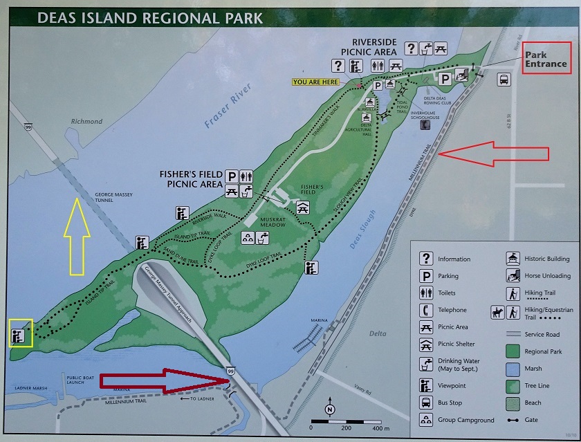
1. To get to the start of Millennium Trail by Deas Island Regional Park in North Delta, take River Rd (or 62b Street, if arriving from the other side). In this photo of a map provided by Metro Vancouver at an information board in the park, the red square indicates the park entrance where you can leave your vehicle, the yellow arrow shows Massey Tunnel, the bright red arrow points to the first half of the Millennium Trail, and the dark red arrow points to where the trail splits after a pedestrian bridge.
Millennium Trail Map Delta BC Canada
2. Here is the entrance to Deas Island Regional Park. Millennium Trail starts to the left of the yellow gate.

Deas Island Regional Park Entrance Delta British Columbia
3. The start of the trail.

Start of the Millennium Trail near Deas Island Regional Park - Delta
Trail
4. At first, the path goes by some trees. Water views are available on the right side.

Hiking in Delta BC - Millennium Trail
5. Then, there is what appears to be a hobby farm on the left side.

Hobby farm seen from Millennium Trail - Delta BC Hiking
6. A llama and a donkey at the farm.

A llama and a donkey
7. Soon, a large farmer's field arrives to the left.

Farmer's field seen from the Millennium Trail in Delta BC
8. A tractor and a worker in the field.

A tractor and a worker on a field in Delta BC
9. The worker up close.

Farm worker Delta BC Canada
10. Just under 1.5 kilometers from the start of the trail, Riverwatch Residences at 6251 River Road appear on the right side.

Riverwatch Residences Delta BC Canada
11. Past the townhouses, there is a split. To the left is 60th Avenue, which leads to Massey Tunnel bike shuttle one kilometer later. Straight ahead is the continuation of the trail.

12. Looking left at 60th Avenue.

60th Avenue Delta BC
13. But we are going straight.

Delta British Columbia Canada
14. At the end of the paved road, the path turns right and enters into a very pleasant, if small, forest. However, by now you are right next to Highway 99, and the traffic noise is substantial.

Hike in Delta BC - Millennium Trail
15. Alas, the forest quickly ends, and walking on the side of the highway begins.

Millennium Trail by Highway 99 in Delta British Columbia Canada
16. A neat view to the right, though.

Riverhouse Marina seen from the Millennium Trail Delta British Columbia
17. Zooming in, we see the townhouses we passed by a few minutes earlier, as well as Riverhouse Marina.

Riverhouse Marina Delta BC Canada
18. The trail then proceeds under Highway 99.

Millennium Trail Delta BC
19. And, soon, there is a pedestrian bridge ahead.

20. Here it is, at about 2.5 km from the start of the hike.

Bridge on Millennium Trail Delta BC
21. The view from the bridge.

Hike in Delta BC
22. After the bridge, the trail splits. Taking the path to the right leads past Captain's Cove Marina. This part of the trail ends one kilometer later, and is a more picturesque of the two parts of the trail after the bridge.

Millennium Trail Delta BC
23. Looking back, wee see the Highway 99 bridge, under which we crossed a few minutes earlier, as seen in photo #18.

BC Highway 99 bridge in Delta BC as seen from the Millennium Trail
24. And, straight ahead, is Captain's Cove Marina. If you have a choice, dock as far from the highway as possible - there would be less traffic noise.

Captain's Cove Marina Delta British Columbia Canada
25. A fine piece of art is located by a bench on the side of the trail.

Art on the side of the Millennium Trail in Delta BC
26. There are three installations inviting you to identify trees (by looking at their leaves), birds, and fish. Here is the piece with the leaves.

Delta Street Art British Columbia Canada
27. One kilometer past the trail split, this part of the trail ends at Admiral Way (by Ferry Road). There is a washroom inside the building with the city of Delta logo.

Washroom in Delta BC on Admiral Way
28. Now we are walking to the left after crossing the bridge seen in photo #20. This part of the trail is about 1.2 km long one way, and goes past some townhouses at first.

Delta BC Millennium Trail
29. Next is a golf course.

Golf course by Millennium Trail in Delta British Columbia Canada
30. A fine view through a chain link fence.

Gold Course Delta BC Canada
31. Then, more residences arrive - it is now Commodore Drive.

Commodore Drive Delta BC
32. Finally, the end of the trail at Admiral Blvd by Neilson Elementary school.

Hiking in Delta BC
Millennium Trail has several fine views, and could be a good recreational option, if you don't mind the traffic noise.


|
 |
![]()
![]()
![]()
ihikebc.com Trip 154 - Millennium Trail Hike (Delta BC)